Geosciences in Central South University: A state-of-the-art review
��Դ�ڿ������ϴ�ѧѧ��(Ӣ�İ�)2020���4��
�������ߣ������� ������ ������ �ſ��� ë�ȳ� ������ ������ �˺� ��ƽ�� ���ܺ� ���� ���氲
����ҳ�룺975 - 996
Key words��geophysics; geology; geochemistry; geological engineering
Abstract: In recent decades, colleagues working in the Discipline of Geological Resources and Geological Engineering at Central South University made significant progress in theoretic study and application of geophysics, ore deposit and shale gas geology, 3D predictive modeling of concealed resources, and geological engineering. In geophysics, world-class progress was achieved in the development, data processing, equipment, and scientific survey of electromagnetic method in onshore and offshore environments and the tectonic evolution of the Tibetan Plateau. Especially, advanced wide-field electromagnetic exploration method and equipment as a highlight technique won the first prize of National Science and Technology Invention of China. In ore geology, progressive and complex characteristics of most nonferrous ore deposits and the geodynamic relationship between crust-mantle reaction and mineralization in south China were revealed. Progressive metallogenic models of certain typical ore deposits were established based on the study of fluid inclusion and geochemistry. According to characteristics of complex metallogenic system of polygenetic ore deposit, key ore-controlling factors were found and summarized. The investigation on unconventional resources advanced China��s shale gas resource evaluation system. In 3D predictive modelling of metallogenic, a large-scale location prediction model was established for exploration of crisis mines and concealed ore deposits. Our developed 3D predictive modeling techniques for concealed orebodies were widely used to explore deep mineral resources in China. In geological engineering area, the key technologies for deep drilling into complex formations were developed. Especially the drilling fluid and tools were utilized in the fieldwork. The rock and soil mechanics analysis method and anchor technologies were also established and applied to engineering practice.
Cite this article as: GUO Zhen-wei, LAI Jian-qing, ZHANG Ke-neng, MAO Xian-cheng, WANG Zhi-lin, GUO Rong-wen, DENG Hao, SUN Ping-he, ZHANG Shao-he, YI Miao, CUI Yi-an, LIU Jian-xin. Geoscience in Central South University: A state-of-the-art review [J]. Journal of Central South University, 2020, 27(4): 975-996. DOI: https://doi.org/10.1007/s11771-020-4347-5.

J. Cent. South Univ. (2020) 27: 975-996
DOI: https://doi.org/10.1007/s11771-020-4347-5

GUO Zhen-wei(������), LAI Jian-qing(������), ZHANG Ke-neng(�ſ���), MAO Xian-cheng(ë�ȳ�), WANG Zhi-lin(������), GUO Rong-wen(������), DENG Hao(�˺�), SUN Ping-he(��ƽ��),
ZHANG Shao-he(���ܺ�), YU Miao(����), CUI Yi-an(���氲), LIU Jian-xin(������)
School of Geosciences and Info-Physics, Central South University, Changsha 410083, China
 Central South University Press and Springer-Verlag GmbH Germany,part of Springer Nature 2020
Abstract: In recent decades, colleagues working in the Discipline of Geological Resources and Geological Engineering at Central South University made significant progress in theoretic study and application of geophysics, ore deposit and shale gas geology, 3D predictive modeling of concealed resources, and geological engineering. In geophysics, world-class progress was achieved in the development, data processing, equipment, and scientific survey of electromagnetic method in onshore and offshore environments and the tectonic evolution of the Tibetan Plateau. Especially, advanced wide-field electromagnetic exploration method and equipment as a highlight technique won the first prize of National Science and Technology Invention of China. In ore geology, progressive and complex characteristics of most nonferrous ore deposits and the geodynamic relationship between crust-mantle reaction and mineralization in south China were revealed. Progressive metallogenic models of certain typical ore deposits were established based on the study of fluid inclusion and geochemistry. According to characteristics of complex metallogenic system of polygenetic ore deposit, key ore-controlling factors were found and summarized. The investigation on unconventional resources advanced China��s shale gas resource evaluation system. In 3D predictive modelling of metallogenic, a large-scale location prediction model was established for exploration of crisis mines and concealed ore deposits. Our developed 3D predictive modeling techniques for concealed orebodies were widely used to explore deep mineral resources in China. In geological engineering area, the key technologies for deep drilling into complex formations were developed. Especially the drilling fluid and tools were utilized in the fieldwork. The rock and soil mechanics analysis method and anchor technologies were also established and applied to engineering practice.
Key words: geophysics; geology; geochemistry; geological engineering
Cite this article as: GUO Zhen-wei, LAI Jian-qing, ZHANG Ke-neng, MAO Xian-cheng, WANG Zhi-lin, GUO Rong-wen, DENG Hao, SUN Ping-he, ZHANG Shao-he, YI Miao, CUI Yi-an, LIU Jian-xin. Geoscience in Central South University: A state-of-the-art review [J]. Journal of Central South University, 2020, 27(4): 975-996. DOI: https://doi.org/10.1007/s11771-020-4347-5.
1 Introduction
The first-level discipline of geological resources and geological engineering of Central South University (CSU) originates from Central South Institute of Mining and Metallurgy, which was merged on November 1, 1952 by the Wuhan University, Hunan University, Sun Yat-sen University, Guangxi University, Nanchang University and Department of Geology, Mining and Metallurgy of Beijing Institute of Technology. When the college was established, it had two majors: Metal and Nonmetal Mineral Geology and Exploration and Prospecting Technology. In 1958, it added a major of Geophysical Prospecting. The subject was awarded the first batch of national master��s and doctoral degrees in 1981. The master��s degree was established in 1982, the doctoral degree and the post-doctoral research mobile station were established in 1985. The Mining Resource Prospecting and Exploration (including Applied Geophysics) was evaluated as a national key discipline in 1987. In 1997, it was awarded the first batch of doctoral degree awards for first-level disciplines. During 2001 and 2007, Geodetection and Information Technology was rated as a national key discipline. It is the country��s first batch of National 211 Project and National 985 Project key construction disciplines of China.
Since 2000, we have independently developed the ��Diwa Theory��, Shell Geotectonics, ��Pseudo Random Signal Coding Electrical Method�� and multi-factor complex metallogenesis. Based on the theories, it has developed a pseudo-random electromagnetic exploration system and a wide- field electromagnetic exploration system that are very effective for solid mineral resources and unconventional oil and gas exploration, and carried out extensive promotion and application at home and abroad. Among them, the ��Theory and Application of Uniform Broad-Spectrum Pseudo- Random Signal Coding Electromagnetic Method�� won the second prize of National Science and Technology Invention Award in 2006, and the ��Large-depth high-precision wide-area electromagnetic exploration technology and equipment�� won the first prize of National Science and Technology Invention Award in 2018.
This discipline is the national key discipline that directly serves the national economy in order to use the organic combination of resource exploration, geology and geophysics for the deep side of crisis mines. In the past 20 years, the discipline has been guided by the established theory of mineralization and ore prospecting, and developed advanced instruments. It has played an important role in the exploration of deep-side resources of mines and metallogenic belts at home and abroad. The discipline has been applied in many domestic and foreign mines. Finding out a large number of mineral resources has alleviated the resource crisis of a large number of mines, and achieved great economic and social benefits. This discipline also enjoys a high reputation in the country for its achievements in drilling technologies for complex formations, theories and technologies for drilling tools for extreme formations, monitoring and prevention of geological hazards, and quantitative prediction of three-dimensional visualization.
There may be a notion that geophysical theory and concepts are now thoroughly understood, such as new books and articles addressing very fundamental questions [1-3]. The status of electromagnetic (EM) has been reviewed, and predictive developments have been made in different ways throughout the history of EM [4-8]. Meanwhile, the geophysics group in CSU has developed the geophysical theory and application in the past 20 years, and the details are introduced in the ��Geophysics�� section.
While traditional mineral predictive modeling is refined in past 20 years, it is typically applied in 2D scenario that is to identify exploration targeting areas especially in regional scales [9-13]. Targeting concealed and deep-seated orebodies is extremely challenging due to scarcity of deep geological information [13]. While the team in CSU has developed and boosted theory and techniques of 3D predictive modelling of concealed orebodies [14-19].
We have reviewed the publications more than 3000 papers both in English and Chinese. It is difficult to review all of the publications. In this paper, we give the statistics for the recent ten years and quantities of major references cited in Figure 1.
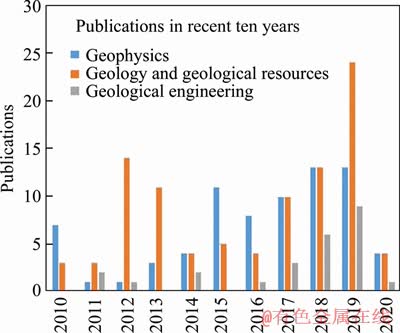
Figure 1 Publications cited in this paper of geological resources and geological engineering in recent ten years
2 Geophysics
In the past 20 years, the EM group has developed fast within the EM theory, modeling, inversion, and applications. With the development the EM method, HE [20] also designed the wide field electromagnetic system and equipment for the deep exploration such as hydrocarbon reservoir, shale gas reservoir, and deep mineral deposits. The marine EM technique has been also developed with both the theory and equipment [21].
2.1 A brief history of geophysics development
TIKHONOV [22] and CAGNIARD [23] first introduced the magnetotelluric (MT) method in the 1950s. The EM method developed fast in geophysical exploration in China. Before 2000, BAO and HE [24] defined a dual-frequency IP method for the mineral deposit exploration. After 2000, HE et al [25-27] developed the Pseudo Random Electromagnetic (PSEM) and Wide Field Electromagnetic (WFEM) two frequency EM methods. The WFEM has been successfully applied in the shale gas exploration, because the apparent resistivity was solved from the complete analytical expressions of the horizontal electrical field source and the vertical magnetic field source with a homogeneous half-space. Wide field apparent resistivity was defined from the analytical expressions of either the horizontal electrical field source or the vertical magnetic field source on the surface of a homogeneous half space. HE [20] established a new frequency domain sounding method as wide field electromagnetic method.
Marine electromagnetic method has been rapidly developed during last twenty years. Researchers designed the seafloor equipment for identifying hydrocarbons in the late 1990s. GUO et al [28] discussed the difference of seabed logging (SBL) and the towed streamer electromagnetic (EM) data acquisition system. Recently, marine transient electromagnetic (TEM) and controlled-source electromagnetic (CSEM) surveys have been both applied for the SMS exploration. In recent years, China has started SMS investigation, for instance, the Southwest Indian Ridge (SWIR) [29]. TAO et al [30] obtained the TEM data for SMS deposits at the South Atlantic Ridge 13.2�� hydrothermal area using the equipment designed by CSU.
The research of the Tibetan Plateau where is closely related to the collision between the Indian and Asian plates has been modeled in different ways. Various models have been developed to describe the tectonic evolution and uplift of the Tibetan Plateau [31, 32]. It is generally believed that the collision has caused a southeast to southward extrusion along its SE margin, although it is not clear whether extrusion occurred at whole crustal or mainly lowers crustal level. These observations suggest a lower crustal extrusion beneath the SE Tibet. SUN et al [33] design a lower crustal flow model to show the lower crustal material flow from the central Tibetan Plateau. They apply the seismic technology to the Longmenshan area, the result show that the lower crustal flow may extrude upward into the upper crust along steeply dipping thrusts under the Longmenshan belt, due to the continuous extrusion of Tibetan material. All those results provide a good geophysical evidence for uplift of Tibet Plateau and its geodynamic mechanism [34].
2.2 Modeling and inversion of EM field data
The EM numerical simulation methods commonly include the finite element method, the finite difference method and the integral equation method. The numerical simulation method has rapidly developed in following aspects: differential control equation, finite element space, mesh discretization, linear solver [35]. It is a common way to simulate EM field by using the vector basis function replacing the node type basis function in the finite element space.
In order to simulate the complex geological structure, mesh discretization technique preferred the unstructured mesh. Based on the unstructured mesh technique, the local dense mesh is applied in 3D resistivity simulation [36, 37], 2.5D DC resistivity modeling [38], and adaptive FEM in EM field modeling [39]. ZHANG et al [40] proposed a 3D infinite element numerical simulation method for the CSEM data modeling based on the second-field. TANG et al [41] proposed a method for the complex structure modeling based on the complete integral formula, tetrahedral unstructured mesh and singular reference points.
Computational speed and computational accuracy have always been the dilemma of forward and inversion. REN et al [42] improved the accuracy of the 3D MT data by the integral equation method by discretizing the subsurface anomaly with tetrahedral elements. They solved the strong singularity problem of the dyadic Green's function using the analytical expression without singularity. Efficient controlled source EM modeling algorithm is developed to modeling EM diffusion in the Earth by LIU and GUO [43-45].
ZHOU and XIE [46] proposed a new structured grid subdivision technology based on the 3D finite element method and applied it to the forward modeling of SP signals. XIE et al [47] studied the 3D numerical modeling of biogeobattery system from microbial degradation of underground organic contaminants using the coupled method of tetrahedral finite elements and hexahedral unidirectional mapping infinite elements. Furthermore, XIE [48] performed the 3D forward modeling of seepage SP using a new coupled method of tetrahedral finite elements and 3D regular multidirectional mapping infinite elements and applied it to a landfill model with dynamic leakages.
The commonly inversion algorithms are including two categories: Linear and nonlinear inversion algorithms, such as Gauss-Newton, Conjugate gradient algorithm, and artificial neural grid, simulated annealing algorithm. Linear iterative algorithms are applicable to 2D and 3D electromagnetic problems [49].
Here, we discuss the development of the EM data processing, inversion algorithms and interpretation. Bayesian inversion of MT data is carried out to obtain uncertainty estimation of subsurface structure [50-53]. The data error correlation on the inversion is well exploited in the work [51, 53]. 3D MT data forward modeling and inversion techniques have been applied to the calculation and interpretation of measured data [54]. REN et al [55] reduced the 3D MT inversion computational cost by using a new forward modeling method computed by integral equation.
2.3 EM application and interpretation
GUO et al [21] reviewed the application and development of electromagnetic methods, such as MT, AMT, CSAMT, TEM [56] and WFEM, respectively. Fast magnetotelluric modeling algorithm has been developed to model the apparent resistivity and phase response of the Earth [57-59].
The AMT method measures the natural EM field, and the light equipment is suitable for mountainous areas with relatively complex terrain. Theoretically, it can detect the target with two kilometers depth. Because the natural EM signal is weak, TANG et al [60] improved the coherence and signal-to-noise ratio of electromagnetic sounding data using far reference technology to remove the noise. TANG et al [41] proposed a self-learning feature structure of human noise from observation data through dictionary learning method to identify and separate human noise in AMT data.
Controlled source electromagnetic (CSEM) method has high sensitivity to the resistive hydrocarbon in the offshore exploration. The classic inversion method was introduced as Occam inversion by CONSTABLE et al [61]. GUO et al [62] proposed an irregular sparse mesh to reduce the number of free parameters for the CSEM inversion. The seismic image has high resolution, GUO et al [63] combined the advantage of seismic resolution and EM sensitivity to enhance the marine CSEM inversion. GUO et al [63] defined the seismic image-guided Occam inversion to invert the marine CSEM data.
On land, the CSAMT method is usually applied for the mineral exploration. The CSAMT survey has been applied and carried out the polymetallic (Pb-Zn) deposits in Jianshui region by GUO et al [64]. TEM is time domain electromagnetic method (TDEM) of artificial source electromagnetic exploration. In order to solve the influence of the mutual inductance of the transmitting and receiving coils in shallow detection, XI et al [65] proposed synthesizing the zero-flux plane of the primary field by the equivalent anti-magnetic flux method, and performing secondary field observation on the plane. In this way, the pure secondary field response can be obtained. GUO et al [62, 63] studied the selection of data acquisition and CSEM data inversion methods with various water depths by marine CSEM method. Seabed hydrothermal sulfide ore deposit can be detected by marine TEM method. XI et al [66] analyzed the measured data of the hydrothermal sulfide ore deposit in the mid-Atlantic mid-ocean ridge and the southwest Indian Ocean. The authors simplified the deposits into a 3D target for TEM forward modeling.
In an effort to reduce the shale gas exploration risks and costs, we applied the wide-field electromagnetic method (WFEM), because of its strong anti-interference capability, high resolution, ability to conduct exploration at large depths, and high efficiency, to the Bayan Syncline in the South Huayuan block, Hunan Province [67]. XUE [68] reviewed and analyzed research and applications of the frequency-domain electromagnetic sounding method (FDEM), WFEM, modified central-loop TEM, and short-offset grounded-wire TEM with obvious near-source characteristics. HE [69] applied 3D WFEM and borehole-surface flow field fitting (FFF) high-resolution exploration technique in the Anjialing No. 1 Coal Mine, which gathered detailed geological data for the goaf and water-bearing zones.
2.4 Gravity data processing, inversion and interpretation
Fast and accurate forward modeling methods for computation of the gravitational fields are required for many geophysical applications, especially in the crustal corrections and density inversion. In Cartesian coordinate system, geological structures are commonly approximated as a sum of sample cells, such as sphere, cylinder, polygon, prism and lamina, etc. However, the computational efficiency of spatial domain methods is significantly low when the study region is large, requiring a very fine spatial discretization. Recently, REN et al [55, 70, 71] developed the singularity-free analytical formulas of arbitrary 3D polyhedral mass bodies with spatially variable density contrast. CHEN et al [72] presented a new analytical formula for gravitational field of a polyhedral prism with depth-dependent density contrast. ZHAO et al [73] presented a Fourier domain gravity forward method on the basis of the Gauss fast Fourier transform to increase the computational efficiency by two orders of magnitude and to solve the inherent defects of the Fourier domain methods based on FFT, e.g., aliasing, edge effort, imposed periodicity and truncation effect.
In spherical coordinate, subsurface mass distributions are typically discretized into tesseroids rather than rectangular prisms to consider the curvature of the Earth when tackling large-scale problems. ZHAO et al [74] proposed an equivalent storage strategy for the 3D large-scale gravity forward modeling and inversion, which increases the computational efficiency by approximately two orders of magnitude and largely decreases the memory requirement. ZHONG et al [75] derived new integral formulae for the gravity effects of a tesseroid element, which uses less computational cost to obtain desired solutions, compared to original volume integral formula.
Recent satellite missions provide us with high-resolution gravity models on global scales, including areas without terrestrial data. These kinds of high-resolution gravity models have been widely used to estimate the internal structure, thermal state and rheological properties of the lithosphere. With the application of the global gravity and topography data, CHEN et al [76] obtained the strength and mechanical anisotropy of the lithosphere on the southeastern Tibetan Plateau and provided some constraint on the deformation of the Tibet. Subsequently, the lithospheric rigid in the whole Tibet, the Arabian plate and European area were studied [77-79], which provide significant implications for lithospheric structure and deformation of the Tibetan Plateau, Arabian and European area. Due to the remoteness and severe climate, little is known about the thermal and rheological properties of the Antarctic lithosphere. CHEN et al [80] applied the new ice thickness, bedrock topography and a combination of satellite and high-resolution terrestrial gravity data to provide a proxy for the thermal and rheological properties, revealing the tectonic fragmentation of the lithosphere on the Antarctica.
Lots of new artificial intelligence technology are introduced into the process of SP data inversions. CUI et al [81] studied a model based on the impedance network analogy to realize the 3D fast inversion of monitoring resistivity data, which could effectively reflect the track of underground contaminant diffusion. ZHU et al [82] designed the inversion algorithm for SP data using the particle swarm optimization. CUI et al [83] used four intelligent optimization algorithms of simulated annealing, genetic, particle swarm optimization, and ant colony optimization to studied the inversion of SP data. ZHU et al [84] performed the inversion of SP sources based on the least square regularization and the finite element method. Papers proposed a self-potential particle filter inversion algorithm based on the resampling strategy, where the particle filter algorithm can get a set of particles to approximate the posterior probability distribution of system parameters at a certain time [85-87].
2.5 Equipment
At present, the EM survey equipments are including V-8 multifunction receiver from Phoenix in Canada, GDP 32II Multi-function receiver from Zonge in the USA (Zonge and Hughes, 1998), STRATAGEM EH4 system from Geometrics company in the USA, GMS-07E system from Metronix in Germany, terra-TEM from Monex Geosope in Australia. Most of the equipment above combine the frequency and time domain EM data acquisition method.
In recent years, the EM equipment have rapidly developed in China. Central South University successfully developed the JSGY-2 wide-field electromagnetic instrument, which can measure in a wide area from the far region. The working frequency range is 3/256Hz-8192Hz, and the source transmitted a pseudo-random signal. The receivers only measured the Ex component field. So the method has the advantages of large exploration depth, high efficiency, high precision, and strong adaptability [25, 26]. The WFEM equipment has been produced at the same time, which was shown in Figure 2 [25, 88].

Figure 2 Equipment of wide field electromagnetic system
PEI and JIANG designed the receivers for the wide-field electromagnetism system using AD7722. And the pseudo-random electromagnetic signals were transmitted at several frequencies on frequency-division sections [89]. HE [88] invented the new geophysical exploration method WFEM, which constructed the technical system of holographic electromagnetic exploration.
In order to detect the massive sulfide deposits in deep water, SHENG et al [90] designed and developed a towed TEM data acquisition system for offshore environment. The marine TEM system is shown in Figure 3.
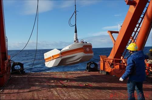
Figure 3 Marine towed transient electromagnetic system
3 Geology and geological resources
In the past 20 years, the Discipline of Geological Resources has experienced a stage of rapid development and entered a brand-new period. In this stage, the traditional ��Diwa theory�� and metallogeny theory have been inherited and developed, and full progress has been made in metallogeny theory of polygenetic compound deposits, metallogenic regularity of ore deposit, concealed ore location prediction and other aspects, and expanded to the fields of oil and gas and unconventional resources.
3.1 Progressive metallogenic model of polygenetic compound deposits
The continental crust of China underwent periodic evolution, and most nonferrous ore deposits, especially large-medium scale deposit experiencing multistage and progressive metallo- genic are typically polygenetic ore deposits. Based on the deep crustal dynamic research, the metallogeny researches were carried out in the metallogenic belts of Nanling, Qinzhou-Hangzhou, the middle and lower reaches of the Yangtze river, the Kunlun-Qinling-Dabie, the southern margin of North China, and Tethys.
The influence of far-field stress transmission derived from the convergence of Australia and the South China Block is the main reason to induce the Caledonian intracontinental orogenic event. We suggested that those Mesozoic magmatic and ore-formed events were highly related the extensional events in palte internal [91-93].
Study on the geodynamic background and mineralization of porphyry molybdenum deposits in Qinling-Dabie metallogenetic belt was carried out. LIU et al [94] indicated that the molybdenum mineralization was controlled by fractionation crystallization, and established the corresponding models of tectono-magmatic evolution and molybdenum mineralization.
Through the comprehensive geological- geochemical study on the margin of the north China craton, the pre- and post-mineralized evolution history in the Longshoushan area was reconstructed [95]. The tectonic evolution and mineralization history of the western margin of the North China craton were analyzed [96]. Through the studies of Erenhot gabbro-granite complexes in the China-Mongolia ridge-basin area, the crust-mantle interactions and its related magmatic activities within the process of lithospheric extension and thinning were analyzed, which confirmed the extensional tectonic environment of lithosphere during early Cretaceous in the China-Mongolia ridge-basin area [97].
Based on the crustal movement and evolution, we provided a detailed synthesis of ore-forming setting, ore geology, and metallogenic regularities of ten Cu polymetallic deposits in the Yunnan province [98]. Furthermore, the polygenetic characteristics of Cu-Au ore deposits in Tongling district were summarized for guiding ore prespecting inside and outside this district [99-101].
The stratabound character, variability and multi-generation in the Tianmashan gold deposit were summarized. The ore-forming experienced the hot-water sedimentary mineralization in Carboniferous and magmatic-hydrothermal mineralization in Yanshanian, which were the keys of mineralization in Tianmashan deposit [102-104].
The authors proposed the metallogenic model of dynamic hydrothermal mineralization on the studies of Dayingezhuang, Xiadian, Hedong and Shangzhuang gold deposits in northwest Jiaodong peninsula. The keys of the model were dynamic changes of physical chemical conditions in the shallow crustal environment and their restriction on the water-rock interaction, circulation of sulphur and carbon, activation, migration and aggregation of ore metals [104, 105].
According to the ore-forming epochs, Fankou lead-zinc sulfide ores were divided into two different metallogenic systems, Indosinian and early Yangshan periods. ZHANG et al [106] defined ��Fankou type�� lead-zinc deposit, which the ore-forming materials has multiple sources.Figure 4 showed the prediction geological model of Fankou lead-zinc deposit. The geothermal events in basin and basement aquifer system was the main driving factor of the ore-forming fluid��s formation and evolution [106].
CHENG [107] proposed a new concept of generalized contacting structure to study and analyze on the mineralization of nonferrous and rare metal deposits in Nanling area [107]. Based on the anatomy of Dongguashan Cu (Au) deposit and Xinqiao Cu-S-Fe deposit in the Middle-Lower Yangtze River Valley Metallogenic Belt (MLYRB), and Yongping Cu deposit in the Qinzhou-Hangzhou Metallogenic Belt (QMB), the source of ore-forming fluids, the rock- and ore-forming dynamic backgrounds and the spatial-temporal distribution of these deposits have been systematically studied, which further proved that the layered deposits in the MLYRB and QMB were stratabound skarn-type deposits [106, 108-112].
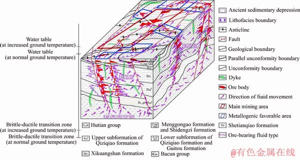
Figure 4 ��Fankou type�� lead-zinc deposit prediction geological model
We have systematically studied the formation background and tectonic evolution of Jinchuan copper nickel sulfide deposit, Gansu Province, and the time nodes of tectonic evolution and mineralization in Jinchuan mining area were precisely determined. Based on the distribution of platinum group elements, it was presumed that the Eastern and Western rock masses in Jinchuan mining area were the result of magma emplacement along different magma channels, and a multi-stage metallogenic model of multi-channel system was established [113-116].
The authors have carried out in-depth study on pegmatite type rare metal deposits in Mufushan area, Northeastern Hunan Province. The rare metal mineralized pegmatites were formed in the early/late stage of deep melting, which respectively represented the causes of muscovite dehydration partial melting and water-induced muscovite partial melting. ZHANG et al [117] presented that the western section of Jiangnan orogenic belt was similar to the eastern and middle sections in terms of metallogenic geological background.
Based on the study of Banxi antimony deposit in Hunan Province, the importance of the Neoproterozoic continental splitting tectonic setting for the mineralization of this deposit was demonstrated. The basement tuff of Banxi group formed by the breakup of Neoproterozoic continent has the character of antimony source bed, and the model of low temperature mineralization has been established. LI et al [118-120] proposed that the ��afterheat�� of large-scale magmatic activated heats the ore bearing basement strata, and the extracted ore-forming materials moved to the shallow part of the earth��s crust along with the circulation of fluid and mix with the atmospheric precipitation to form large-scale mineralization.
Based on the Re-Os isotope dating, two metallogenic stages of Axi epithermal gold deposit were identified. The metallogenic processes and mineral evolution were described in detail, and the two-stage metallogenic model of Axi gold deposit was established [121].
In addition, through the fluid inclusion and geochemisty study of Qimantag metallogenic belt, Saishitang cooper deposit, gold deposit in Gouli area, Longtoushan gold deposit, Liyuan gold deposit, Baojinshan gold deposit and Xitian area deposit the metallogenic conditions and processes were analyzed. The metallogenic models were establish through the analysis of the metallogenic system [122-128].
3.2 Metallogenetic regularity and ore-controlling factors
During the study of the mesozoic regional metallogenic structure in southern Hunan, a hot-column trigeminal fault structure was discovered. This structure is considered to be a structural type of mantle convective activity in the early Yanshanian formation in the lithosphere. The existence of mantle activity in the deep part of South China during the Yanshanian period provided deep tectonic background support for the development of the thermal pillar trifurcated fault structure in southern Hunan [129].
Through geology-geophysics-geochemistry- remote information extraction and integrated interpretation, the geological structure pattern of the Fankou mining area and its surroundings was determined, and a number of regional structures were newly discovered. The main structure of Fankou mining area was proposed as a progressive deformation product controlled by boundary conditions during the Hercynian-Indochina period [106, 130].
YANG et al [104] considered the Dayinger- zhuang fault as the ore-conducting structure of the mining area, which had undergone changes from translational shearing before mineralization to the expansion during the mineralization period at Zhaoyuan, Shandong province, in China. An ore-controlling tectonic model of the Yanshanian normal fault in the Xitian area of Hunan was established. The tectonic fault-fluid evolution controlled the tungsten-tin-lead-zinc-fluorite mineralization zone and enriched the structural pattern of the Yanshanian extension in South China [131].
According to the spatial distribution of ore bodies in the Fankou lead-zinc deposit, authors considered that mining area in the north west- nearly east-west fold and its associated faults and interlayer gliding structures were directly ore- controlling structure. By studying on the diabasic dike breaches, the authors put forward new ideas that the late hercynian tectono-magmatic- geothermal fluid mineralization [106, 132].
Authors revealed the spatial pattern of the parallel zoning of the skarn-type orebodies of the Fenghuangshan Copper Mine that ��distribute along the contact zone and lay laterally�� [133, 134]. There were several parallel ore belts in and out of the main contact zone between the granodiorite and the lower Triassic imperious carbonate rocks, which were controlled by faults and secondary folds for deep-side prospecting [102, 133].
The ore body of Gejiu tin deposit occurred at the intersection of secondary structures under the control of Wuzishan anticlinoria, with the contact zone between the Jiagang section of Gejiu formation and the Yanshanian biotite granitoids, especially at the top sag of the protruding rock mass [134, 135]. DAI [136] summarized the vertical three-storey metallogenic model of the distribution of antimony mineralization in Xikuangshan mine deposits, where the antimony orebodies are controlled by the strata and structures, indicating the direction of deep prospecting.
LAI et al [137, 138] carried out a summary study on the ore-forming regularity of typical deposits in the Saishitang copper-polymetallic ore-field in Qinghai, and established ��Trinity�� ore forming model combing ore-forming geological bodies, ore-forming structures, ore-forming structural planes, and ore-forming characteristics. This deposit was attributed to a typical polygenetic ore deposits, which was a contact-metamorphic deposit modified by late magmatic hydrothermal superposition.
The research on the dispersed element indium in the magmatic hydrothermal mineralization system was carried out. An In-rich and Sn-poor skarn deposit, the Qibaoshan Cu-Zn-Pb deposit, has been identified in south China and an independent indium mineral-roquesite was founded in the Saishitang skarn copper deposit [138]. In northeastern Hunan province, Co deposits occur within the hydrothermal alteration zones along the NE-trending Changsha-Pingjiang deep fault zone, and spatially show close association with late Jurassic to early Cretaceous granites. Integrated the geological, mineralogical and geochemical data reveal that Co is hosted within pyrite and arsenopyrite, and was formed from a hydrothermal system related to the Lianyunshan pluton [139-141].
3.3 Research on unconventional resources
The increasing degree of foreign dependence for oil and gas resources in China has become an important bottleneck restricting the national security. Tan��s team of the discipline focuses on basic and forward-looking scientific problems encountered in shale gas evaluation, exploration, and development. Primary achievements over the past years included four aspects. 1) Authors established a model of hydrocarbon generation for over mature marine shales and revealed the initial hydrocarbon generation potential of the Early Paleozoic shales and the phase evolution process of shale oil and gas in marine shales in South China, providing an important theoretical foundation for accurate evaluation of shale gas potential of the over mature marine shale system in that region [142, 143]. 2) Authors revealed the law of influence of physical properties of the marine shale on methane adsorption capacity and the control mechanism of in-situ geological conditions on gas content of the marine shale, laying a scientific foundation for deep study on the control and influence of the shale heterogeneity and in-situ conditions on the gas content [144, 145]. 3) Authors put forward the coupling relationship among the mineral composition characteristics, petrophysical- mechanical properties, and tectonic-sedimentary environment of the marine shale in South China and established the formation and evolution model of micro-nano pore structure of the shale, providing an important theoretical support for deep study on the fracturing and gas recovery from the shales in South China [145-147]. 4) Authors discovered the depositional environment and organic matter accumulation mechanism of the Niutitang shale in different stages of geological evolution, according to the paleoclimate, paleoproductivity, redox conditions and seawater restriction proxies [148].
Focusing on the genetic mechanism of clastic rock reservoir and theoretical issues such as hydrocarbon-water-rock interactions during diagenesis, HU et al [149] proposed a new mechanism for the thermochemical oxidation of methane into carbon dioxide induced by high- valence Mn(Fe) oxides. In the Early Triassic Baikouquan Formation of the Junggar Basin in NW China, methane from deeper source strata was abiotically oxidized by high-valence Mn(Fe) oxides at 90 to 135 ��C during diagenesis, releasing 13C-depleted CO2, soluble Mn2+ and Fe2+. A coupling mechanism of the dissolution of orthoclase molecule in perthites and the yilitization of montmorillonite during diagenesis was elucidated, as well as the associated secondary pore formation model [150, 151].
The spatial and temporal distribution patterns of the two sets of black shale under the framework of graptolitic biozones were well defined, which help to delineate favorable shale gas intervals, and the results are directly used to guide and infer shale gas exploration on the potentially Lower Yangtze shale gas reservoirs and the eastern margin of the Sichuan Basin on the Upper Yangtze Region [152, 153]. The characters and variations of the autopores within different types of microfossils were revealed and helped to build up a qualitative and quantitative evaluation criterion. The study revealed the influence on shale reservoir evaluation caused by the development of microfossil pores [154].
For non-aqueous fracturing in unconventional oil and gas and geothermal recovery, the effects of supercritical CO2 and CO2 based water or brine imbibition on the mechanical properties and permeability of shale, sandstone and granite were investigated by means of uniaxial compressive strength tests, tri-axial compressive strength tests and Brazilian split test [147]. Seismic forward modeling and inversion, such as complex wavefield simulation, seismic source location, source mechanism inversion, and comprehensive interpretation of geomechanics, of induced seismicity associated with unconventional reservoirs are conducted to characterize fractures of the reservoir and manage seismic risks [156, 157].
3.4 Theory and method of concealed ore location prediction
As an example for Tongling ore concentration area, through deepening the understanding of copper (gold) polymetallic metallogenic system and localization law, a large scale location prediction model for deep edge of copper mine in crisis is established, to explore the theory and method of concealed ore location prediction. Research on ��effectiveness�� evaluation of prospecting technology and development of large-scale 3D visualized positioning and quantitative prediction technology for hidden mines, a large-scale positioning and forecasting technology integration system suitable for crisis mines in the depths of 500-1000 meters in the crisis mines of Tongling Mine Cluster with independent intellectual property rights was formed. It provides reliable scientific and technological basis for the selection of target location in the mine substitute resources verification target area, and a typical example for the study of alternative resources prospecting in crisis mines and the quantitative prediction of location [102, 135].
3.5 Three-dimensional (3D) predictivity of concealed orebodies
While traditional mineral predictive modelling is refined in past 50 years, it is typically applied in 2D scenario that is to identify exploration targeting areas especially in regional scales [9-13, 158]. Targeting concealed and deep-seated orebodies is extremely challenging due to scarcity of deep geological information [13]. With the technical development of geophysical exploration, 3D geological modelling, spatial analysis and visualization, it allows to further combing deep information as another dimension into mineral prospectivity. The team in CSU has developed theory and techniques of 3D predictive modelling of concealed orebodies [14-19]. Specifically, the 3D predictivity of concealed orebodies meets the demand of finding new resources for mature mining districts that is generally a large-scale predictive mapping. Three stages are generally involved in predictive modelling process: a) collecting geological database and 3D geological modelling; b) analysis and extraction of 3D evidential predictors; c) integration of 3D evidential predictors and predictive modelling.
The study of 3D prospective modelling dates back to 1980s, which was applied to tin prospectivity in Xianghualing Deposit [14, 15, 158]. On the basis of constructing geological database [159] and 3D geological models [160-162], analysis and extraction of 3D evidential predictors is essential in targeting concealed orebodies. In contrast to 2D prospectivity modelling, a significant and distinctive data source in 3D prospective modelling is 3D geological models. Given such models including the 3D spatial configuration, shape details and mineralization distribution of the deposits, it allows to extract evidential predictors directly from 3D geological models by using spatial analysis techniques. Aiming at extracting the structural and shape anomalies that might reflect the geophysical and geochemical condition of the mineral system, a series of 3D shape analysis methods for geological bodies are proposed. The earliest shape analysis method [15, 163] is proposed for tin prospectivity modeling in Xianghualing deposit, in which the trend analysis is leveraged in analyzing the wavy structure of faults. Given that trend analysis is limited in complex shape such as overturned, bent and faulted structures, the shape analysis approach based on mathematical morphology [164, 165] is proposed, which is applied in analysis of the intrusion in Fenghuangshan copper deposit [166]. Following the line of research, more general spatial analysis methods such shortest distance analysis, slope analysis and field analysis are further presented [167-169]. Notably, the geodynamic simulation is introduced to provide more evidential predictors related to thermal, mechanical and fluids fields in addition to shape-related predictors [170, 171].
Given the extracted evidential predictors and the known mineralization represented as 3D voxels models, it ensures predictive models for targeting concealed orebodies to be constructed in a data-driven fashion. While the mainstream approach method applies a single model for prospectivity, less attention is drawn to asymmetry of the metallogenic information due to data missing and different geological processes in the research areas. The predictive modelling approach considering the metallogenic information asymmetry is proposed which combines multiple models according to their valid domain [172].
4 Geological engineering
4.1 Soil and rock drilling technology
In order to meet the demand of deep drilling leakage and plugging, the acrylic high-water absorbing resin with water absorption and expansion properties was used as the plugging material [173]. Moreover, based on the technical data published by NASA (National Aeronautics and Space Administration), around the design requirements of sampling drilling in Mars drilling, we discussed the sampling drilling system structural design and contact stability system, auxiliary structural system, pressure and rotary transmission system, closed protective shell (stabilizer) systems, rotary drill systems, turntable systems, drive shaft systems, and impact drilling systems [174].
In order to understand the solid-phase control of drilling fluids well, SUN et al [175] investigated the parameters of drilling fluid and the filter cake properties associated with drill cutting intrusions. From a perspective of microscope, SUN et al [174] studied the relationship between cation exchange capacity in shield slurries and its performance, which attributes to the borehole stabilities by producing a new kind of slurry system. Meanwhile, the ionic stabilizer ENI was used in drilling fluids to prevent ground surface movement and drilling fluid overflowing [174].
The computer science and new engineering machinery were introduced in horizontal directional drilling HDD with the technological advances. Horizontal borehole displacement based on drilling fluid pressure was simulated and analyzed by computer [176]. As for new engineering machinery, jet pump system installed near the drill bit to collect cuttings formed during reaming process, thereby reducing the number of cuttings in the borehole space to prevent overflow [177]. Figure 5 illustrated new technique and applications in complex formations�� drilling.
The response mechanism of scour depth under the combined action of pipe diameter, laying depth, stratum type and scour efficiency is studied by means of theoretical analysis, laboratory experiments and mathematical calculation. An indoor model experiment device was designed and built to realize the inversion analysis and parameter acquisition of the above factors; the influence of disturbance radius on the theoretical scouring depth was studied and analyzed. A calculation model for the scouring depth of HDD riverbed based on the factors of enlargement diameter, depth, trajectory, stratum, velocity and time was proposed to provide reference for the optimal design of trenchless HDD in river crossing [178].

Figure 5 New technologies and applications in complex formations�� drilling
The use of forward and over-reaming and pipe laying techniques helps to reduce drag and improve laying. The comparison operation results indicate that compared with the traditional leachate shaft drainage mode, the horizontal drilling efficiency is higher and the cost input is relatively lower. However, the impact of the heterogeneity of the pile on the construction process should be fully considered in the design and construction to reduce construction risks [179].
4.2 Engineering geology and construction technology
Reticulated red clay widely distributed in the middle and lower reaches of the Yangtze River has relatively unique structural characteristics, and its engineering performance has always been valued by practitioners of geological engineering. The research on the creep properties and loading rate effects of unsaturated reticulated red clay is basically still in the blank stage and far from meeting the needs of engineering practice.
A lot of results have been accumulated in the research of creep characteristics of saturated soil. The research on soil creep began in the early 20th century. The most important results in this time are to summarize the experiential formula of creep calculation based on the soil creep test. Research on creep properties of unsaturated soils has just started in recent years, mainly the following research results. DENG et al [180] showed that the property of the viscous component, having an isotach property, are formulated as a function of the degree of saturation. LI et al [181] studied the creep behavior of unsaturated reticulated red clay under constant loading and step-loading conditions. YE et al [182] studied the creep characteristics of Gaomiaozi unsaturated bentonite under high matric suction, and found the law of sub-consolidation coefficient of Gaomiaozi unsaturated bentonite with matric suction. In order to predict the unsaturated creep behaviors of weak intercalated soils, ZHU and ZHU et al [183] performed creep tests on unsaturated weak intercalated soils by using GDS triaxial apparatus. LIU et al [184] showed that the deformation of unsaturated Red-layers embankment under constant stress conforms to the creep equations with two Kelvin bodies, considering coupling-effect of the unsaturated rheology and consolidation. These results reveal the effects of matric suction on the creep behavior of different types of soil under different loading conditions.
Reticulated red clay is a common clay in the geological engineering practice in the middle and lower reaches of the Yangtze River, China. The soil particles of reticulate red clay are small in size. It has weak to moderate swelling plasticity, moderate compressibility and strong strength [185]. The reticulate red clay involved in engineering practice is mostly non-saturated reticulate red clay. The mechanical properties of unsaturated reticulate red clay directly affect the design and construction of ground (road), foundation pit and slope engineering. Research results and engineering practice showed that the reticulate red clay has obvious creep property [186]. In this paper, step-loading method is used to study the effect of matric loading and matric creep on axial strain and radial strain of unsaturated reticulate red soil under constant net confining pressure using stress-controlled GDS unsaturated triaxial apparatus, which provides reference for the study of creep characteristics of unsaturated soils and the engineering design and construction of unsaturated reticulate red soils.
4.3 Hydrology and environment
With the development of global economy and the acceleration of industrialization and urbanization, more and more attention has been paid to hydrogeology, geological disasters and environmental problems. Among them, the problem of heavy metal pollution in soil and groundwater has become more and more serious due to mineral mining and selection, metal smelting, industrial wastewater discharge, leachate leakage in solid waste disposal, etc [186, 187]. Problems such as garbage siege, industrial pollution, heavy metal pollution from mine and safety of tailings pond become more and more serious. The control and remediation of soil pollution as well as the disposal of solid waste and garbage have a long way to go [186]. They are also the research hotspots of geological resources and geological engineering [187]. In recent years, based on the basic theory of environmental engineering geology, the department of Geological Engineering of Central South University has carried out relevant research with the goal of environmental sustainable development, taking hydrogeology and environmental geology as the starting point, and taking landfill sites, non-ferrous smelting sites, mines and tailings ponds as the engineering background [188, 189].
The migration and retention characteristics of red clay-bentonite engineered barrier to heavy metal pollutants under the chemical-osmotic coupling effect, as well as the self-repair mechanism of engineering barrier system, are taken as the research targets. Through experiments of adsorption, permeation and migration, chemical compatibility of soil materials and self-healing of soil, the retardation characteristics and physicochemical self-repair mechanism of engineering barrier to heavy metal pollutants under the chemical-osmotic coupling effect were revealed [188]. Taking the black moose peak landfill in Changsha, Cheng- men-shan copper mine in Jiujiang, Jiangxi and Dajishan tungsten mine as engineering examples, the migration characteristics of heavy metal pollutants in the groundwater environment were analyzed, and the retention effect of engineering barriers to heavy metal pollutants was discussed [189]. The implementation of this research has important academic significance and practical engineering value for guiding the design, construction and maintenance of engineering barrier systems in heavy metal contaminated sites in China and realizing the prevention and control of heavy metal pollution in soil and groundwater.
4.4 Energy geology and exploration, and mining
Unconventional energy is a significant resource with great potential. Shale gas as the typical unconventional energy, are generally buried at a depth of 3000-5000 m [190, 191]. The marine shale in the Lower Cambrian Niutitang Formation is the dominant shale-gas reservoir in northwestern Hunan, which accounts for more than 70% of unconventional energy in Hunan Province. The interaction between drilling fluid and shale has a significant impact on wellbore stability during shale oil and gas drilling operations [192]. The effects of the drilling fluid activity on the surface and osmotic hydration characteristics of shale are investigated. The relationship between drilling fluid activity and shale swelling ratio was determined to investigate the osmotic hydration behavior [193].
In order to obtain the large scale samples with consistent mechanical and physical properties, twenty sets of proportioning tests were carried out with cementing materials, aggregate, and auxiliary materials. The tests results show that the ratio of cementing material to aggregate (CM/A) and the ratio of quartz sand to coal powder (QS/CP) have significant regulatory effects on the physical and mechanical properties of coal like materials. When the ratio of CM/A is 1/2 and the ratio of QS/CP is 1/2�C5/7, the mechanical and fluid-solid interaction properties of coal-like materials have optimum matching with those of low-rank coals [193].
4.5 Intelligent technology
Compared with conventional research directions described above, applications of artificial intelligence (AI) technology in the field of geological engineering are relatively limited. To the best of our knowledge, the earliest work related to AI applications in geological engineering probably started at the late 20th century, when computer technology was still under development. Unfortunately, this system was not widely used in practice at that time because AI was not as popular as present.
Therefore, geological engineering profession is also facing new challenges brought by the area of big data. AI technologies such as machine learning, computer vision technology, Robert, data mining and visualization are getting more and more attention in different directions of the field of geological engineering, including geotechnical uncertainty analysis and risk assessment [194-195], stratification of geological formations [196, 197].
5 Future developments of geoscience in Central South University
Geophysical methods represent an important tool in global exploration. Currently, geophysical prospecting has to focus on deep exploration targets, deep sea environment. The requirement of the deep penetrating geophysical prospecting need to find out useful tools such as seismic, EM, gravity, and magnetic. Combining the EM, gravity and magnetic method, we are going to design the forward modeling and inversion code. Furthermore, we will design and improve a new 3D electromagnet equipment for deep exploration, which can detect the ore deposit targets buried 4000 m or hydrocarbon targets buried 10000 m.
Marine geophysical techniques have already been very powerful tools for offshore exploration. The 3D geophysical data acquisition and new geophysical equipment can measure large datasets from subsurface data. Hence, the rapid forward modeling and efficient inversion tools need be required. In order to improve the accuracy of the inversion results, geophysical data inversion techniques in conjunction with other geophysical methods will need to be improved. At the same time, marine EM data acquired equipment is also to be designed and developed in the future.
Artificial intelligence and deep learning techniques also provide the potential for improving geological prospecting. It has already been successfully applied in seismic imaging and 3-D interpretations in the oil exploration industry.
In order to meet the deep drilling, drilling fluid materials and properties under high-temperature and high-pressure environment need further research. The pollution mechanism and degradation technology of different drilling fluids are also the focus of future research. At the same time, intelligent monitoring technology will also become the focus of research.
The understanding of the crack development rules in the low permeability reservoirs is significant for the unconventional energy recovery. How to monitor the behaviors of the fracture propagation and networks formation under the different stimulating methods are the key issues for the further investigation in the hydraulic fracturing.
It is planned to apply this achievement to issues related to creep and loading rate effects of unsaturated soils associated with environmental properties about heavy metal pollution in soil and groundwater, the settlement and stability of shallow foundations above the groundwater level, the long-term settlement and stability of unsaturated soils above the infiltration line in the earth dam body, and the deformation and stability problems of unsaturated soils above the groundwater level in slopes (or foundation pit walls).
Acknowledgment
The authors are grateful to Prof. DAI Qian-wei, Prof. SHAO Yong-jun, and Prof. FENG De-shan in Central South University for the information support and thank REN Zheng-yong, SUN Ya, CHEN Bo, LU Guang-yin, TAN Jing-qiang, LIU Lei, YUAN Ling-ling and ZHENG Han in Central South University for valuable discussion on the final version and preparation of this paper.
References
[1] ZHDANOV M. Geophysical electromagnetic theory and methods [M]// Methods in Geochemistry and Geophysics Amsterdam: Elsevier, 2009. DOI: 10.1016/S0076-6895(09) 70001-0
[2] KAUFMAN A A, ALEKSEEV D, ORISTAGLIO M. Principles of electromagnetic methods in surface geophysics [M]// Methods in Geochemistry and Geophysics. Amsterdam: Elsevier, 2014.
[3] SAINSON S. Electromagnetic seabed logging [M]. Berlin: Springer, 2017. DOI: 10.1007/978-3-319-45355-2.
[4] SHEARD S, RITCHIE T, CHRISTOPHERSON K R, BRAND E. Mining, environmental, petroleum, and engineering industry applications of electromagnetic techniques in geophysics [J]. Survey in Geophysics, 2005, 26(5): 653-669. DOI: 10.1007/s10712-005-1760-0.
[5] SIEMON B, CHRISTIANSEN A V, AUKEN E. A review of helicopter-borne electromagnetic methods for groundwater exploration [J]. Near Surface Geophysics, 2009, 7(5, 6): 629-646. DOI: 10.3997/1873-0604.2009043.
[6] SMITH R. Electromagnetic induction methods in mining geophysics from 2008 to 2012 [J]. Survey in Geophysics, 2014, 35(1): 123-156. DOI: 10.1007/s10712-013-9227-1.
[7] STRACK K. Future directions of electromagnetic methods for hydrocarbon applications [J]. Survey in Geophysics, 2014, 35(1): 157-177. DOI: 10.1007/s10712-013-9237-z.
[8] STREICH R. Controlled-source electromagnetic approaches for hydrocarbon exploration and monitoring on land [J]. Surveys in Geophysics, 2016, 37(1): 47-80. DOI: 10.1007/ s10712-015-9336-0.
[9] AGTERBERG F. Combining indicator patterns in weights of evidence modeling for resource evaluation [J]. Nonrenewable Resources, 1992, 1(1): 39-50. DOI: 10.1007/ BF01782111.
[10] CARRANZA E, OWUSE E, HALE M. Mapping of prospectivity and estimation of number of undiscovered prospects for lode gold, southwestern Ashanti Belt, Ghana [J]. Mineralium Deposita, 2009, 44(8): 915-938. DOI: 10.1007/s00126-009-0250-6.
[11] ZUO R G, CARRANZA E. Support vector machine: A tool for mapping mineral prospectivity [J]. Computers & Geosciences, 2011, 37(12): 1967-1975. DOI: 10.1016/ j.cageo.2010.09.014.
[12] PORWAL A, GONZALEZ-ALVAREZ I, MARKWITZ V, MCCUAIGB T C, MAMUSEA A. Weights-of-evidence and logistic regression modeling of magmatic nickel sulfide prospectivity in the Yilgarn Craton, Western Australia [J]. Ore Geology Reviews, 2010, 38(3): 184-196. DOI: 10.1016/j.oregeorev.2010.04.002.
[13] JOLY A, PORWAL A, McCUAIG T C. Exploration targeting for orogenic gold deposits in the Granites-Tanami Orogen: Mineral system analysis, targeting model and prospectivity analysis [J]. Ore Geology Reviews, 2012, 48(10): 349-383. DOI: 10.1016/j.oregeorev.2012.05.004.
[14] MAO X C, CHEN G G. The Xianghualing Sn-deposit: Its mathematical model and three-dimensional quantitative prognostication [J]. Geology and Prospecting, 1988, 24(10): 25-31. (in Chinese)
[15] MAO X C, CHEN G G. Three-dimensional mathematical models of Xianghualing tin deposit and prognosis of blind ore bodies occurring in margins and depths [J]. Journal of Central-South Institute of Mining and Metallurgy, 1991, 22(4): 351-360.
[16] MAO X C, DAI T G, WU X B, ZOU Y H. The stereoscopic quantitative prediction of concealed ore bodies in the deep and marginal parts of crisis mines: A case study of the Dachang tin polymetallic ore deposit in Guangxi [J]. Geology in China, 2009, 36(2): 424-435. (in Chinese)
[17] MAO X C, ZOU Y H, LU X Q, WU X B, DAI T G. Quantitative analysis of geological ore-controlling factors and stereoscopic quantitative prediction of concealed ore bodies [J]. Journal of Central South University of Technology, 2009, 16(6): 987-993. DOI: 10.1007/s11771- 009-0164-6.
[18] MAO X C, ZOU Y H, CHEN J, LAI J Q, PENG S L, SHAO Y J, SHU Z M, LU J W, LU C Y. Three-dimensional visual prediction of concealed ore bodies in the deep and marhinal parts of crisis mines: A case study of the Fenghuangshan ore field in Tongling, Anhui, China [J]. Geological Bulletin of China, 2010, 29(2, 3): 401-413. (in Chinese)
[19] MAO X C, REN J, LIU Z K, CHEN J, TANG L, DENG H, BAYLESS R C, YANG B, WANG M J, LIU C M. Three-dimensional prospectivity modeling of the Jiaojia-type gold deposit, Jiaodong Peninsula, Eastern China: A case study of the Dayingezhuang deposit [J]. Journal of Geochemical Exploration, 2019, 203: 27-44. DOI: 10.1016/j.gexplo. 2019.04.002.
[20] HE J S. Wide field electromagnetic methods [C]// SEG Technical Program Expanded Abstracts 2015. Society of Exploration Geophysicists, 2015: 1006-1011. DOI: 10.4133/ SAGEEP.28-047.
[21] GUO Z W, XUE G Q, LIU J X, WU X. Electromagnetic methods for mineral exploration in China: A review [J]. Ore Geology Reviews, 2020, 118: 103357. DOI: 10.1016/ j.oregeorev.2020. 103357.
[22] TIKHONOV A N. On determining electric characteristics of the deep layers of the earth��s crust [J]. Dolk Acad Nauk SSSR, 1950, 73: 295-297.
[23] CAGNIARD L. Basic theory of the magneto-telluric method of geophysical prospecting [J]. Geophysics, 1953, 18(3): 605-635. DOI: 10.1190/1.1437915.
[24] BAO G S, HE J S. Dual-frequency and multi-parameter IP instrument and its application research [J]. Journal of Central South University of Technology, 1996, 3: 12�C16. DOI: https://doi.org/ 10.1007/BF02652047.
[25] HE J S. Wide field electromagnetic method and pseudo random signal method [M]. Beijing: Higher Education Press, 2010. (in Chinese)
[26] HE J S. Wide field electromagnetic sounding methods [J]. Journal of Central South University: Science and Technology, 2010, 41(3): 1065-1072. (in Chinese)
[27] HE J S. On the closed addition in a three-element set and the 2nd sequence pseudo-random signal coding [J]. Journal of Central South University: Science and Technology, 2010, 41(2): 632-637. (in Chinese)
[28] GUO Z W, DONG H F, LIU J X. Comparison of marine controlled-source electromagnetic data acquisition systems by a reservoir sensitivity index: Analyzing the effect of water depths [J]. Acta Oceanologica Sinica, 2016, 35(11): 113-119. DOI: 10.1007/s13131-016-0954-2.
[29] TAO C H, LIN J, GUO S Q. Discovery of the first active hydrothermal vent field at the ultraslow spreading southwest Indian ridge [J]. InterRidge News, 2007, 16: 25-26. DOI: 10.1190/sbgf2007-205.
[30] TAO C H, XIONG W, XI Z Z, DENG X M, XU Y X. TEM investigations of South Atlantic Ridge 13.2 S hydrothermal area [J]. Acta Oceanologica Sinica, 2013, 32(12): 68-74. DOI: 10.1007/s13131-013-0392-3.
[31] TAPPONNIER P, PELTZER G, LE DAIN A Y, ARMIJO R, COBBOLD P. Propagating extrusion tectonics in Asia: New insights from simple experiments with plasticine [J]. Geology, 1982, 10(12): 611-616. DOI: 10.1130/0091- 7613(1982)10<611:petian>2.0. co;2.
[32] PELTZER G, TAPPONNIER P. Formation and evolution of strike-slip faults, rifts, and basins during the India-Asia collision: An experimental approach [J]. Journal of Geophysical Research: Solid Earth, 1988, 93(B12): 15085-15117. DOI: 10.1029/jb093ib12p15085.
[33] SUN Y, NIU F L, LIU H F, CHEN Y L, LIU J X. Crustal structure and deformation of the SE Tibetan plateau revealed by receiver function data [J]. Earth and Planetary Science Letters, 2012, 349: 186-197. DOI: 10.1016/j.epsl.2012. 07.007.
[34] SUN Y, LIU J X, ZHOU K P, CHEN B, GUO R W. Crustal structure and deformation under the Longmenshan and its surroundings revealed by receiver function data [J]. Physics of the Earth and Planetary Interiors, 2015, 244: 11-22. DOI: 10.1016/j.pepi.2015.04.005.
[35] TANG J T, REN Z Y, ZHOU C, ZHANG L C, YUAN Y, XIAO X. Frequency-domain electromagnetic methods for exploration of the shallow subsurface: A review [J]. Chinese Journal of Geophysics, 2015, 58(8): 2681-2705. DOI: 10.6038/cjg20150807. (in Chinese)
[36] REN Z Y, TANG J T. Finite element modelling of 3-D DC resistivity using locally refined unstructured meshes [J]. Chinese Journal of Geophysics, 2009, 52(10): 2627-2634. DOI: 10.3969/j.issn.0001-5733.2009.10.023. (in Chinese)
[37] YUAN Y. 2.5DC resistivity forward modelling and inversion by finite-infinite element coupling method [D]. Changsha: Central South University, 2013. DOI: 10.1111/1365-2478. 12298. (in Chinese)
[38] TANG J T, GONG J Z. 3D DC resistivity forward modelling by finite-infinite element coupling method [J]. Chinese Journal of Geophysics, 2010, 53(3): 717-728, DOI: 10.3969/ 1.issn. 0001-5733.2010.03.027. (in Chinese)
[39] REN Z Y, KALSCHEUER T, GREENHALGH S,MAURER H. A goal-oriented adaptive finite-element approach for plane wave 3D electromagnetic modelling [J]. Geophysical Journal International, 2013, 194(2): 700-718. DOI: 10.1093/ gji/ ggt154.
[40] ZHANG L C, TANG J T, REN Z Y, XIAO X. Forward modelling of 3D CSEM with the coupled finite-infinite element method based on the second field [J]. Chinese Journal of Geophysics, 2017, 60(9): 3655-3666. DOI: 10.6038/cjg20170929.
[41] TANG J T, ZHOU F, REN Z Y, XIAO X, QIU L W, CHEN C J, CHEN H. Three-dimensional forward modelling of the controlled-source electromagnetic problem based on the integral equation method with an unstructured grid [J]. Chinese Journal of Geophysics, 2018, 61(4): 1549-1562. DOI: 10.6038/cjg2018L0303. (in Chinese)
[42] REN Z Y, CHEN C J, TANG J T, ZHOU F, CHEN H, QIU L W, HU S G. A new integral equation approach for 3D magnetotelluric modelling [J]. Chinese Journal of Geophysics, 2017, 60(11): 4506-4515. DOI: 10.6038/ cjg20171134. (in Chinese)
[43] LIU R, GUO R W, LIU J X, MA C Y, GUO Z W. A hybrid solver based on IEM and vector FEM for 3D CSEM modelling [J]. Geophysics, 2018, 83(5): 1-42. DOI: 10.1190/geo2017-0502.1.
[44] LIU R, GUO R W, LIU J X, LIU Z. An efficient footprint-guided compact finite element algorithm for 3-D airborne electromagnetic modelling [J]. IEEE Geoscience and Remote Sensing Letters, 2019, 16(12): 1809-1813. DOI: 10.1109/ LGRS.2019.2913896.
[45] LIU R, GUO R W, LIU J X, WANG J X, LIU Z. 1D EM response modelling with arbitrary source-receiver geometry based on vector potential and its implementation in Matlab [J]. Geophysics, 2020, 85(3). DOI: 10.1190/geo2019-0224.1.
[46] ZHOU Z S, ZHU H L, XIE J, LIU S Q, YANG Y. 3D finite element forward modelling of self-potential based on a new subdivision technology [J]. Journal of Chengdu University of Technology: Science and Technology Edition, 2019, 46(6): 754-761. (in Chinese)
[47] XIE J, CUI Y A, ZHANG L J, GUO Y J, WANG J X, FANIDI M, LIU J X. Numerical modelling of biogeobattery system from microbial degradation of underground organic contaminant [J]. SN Applied Sciences, 2020, 2(2): 208. DOI: 10.1007/ s42452-020-2008-9.
[48] XIE J, CUI Y A, ZHANG L J, MA C Y, YANG B, CHEN X L, LIU J X. 3D forward modelling of seepage self-potential using finite-infinite element coupling method [J]. Journal of Environmental and Engineering Geophysics, 2020. (in Press)
[49] TANG J T, REN Z Y, ZHOU C, ZHANG L C, YUAN Y, XIAO X. Frequency-domain electromagnetic methods for exploration of the shallow subsurface: A review [J].Chinese Journal Geophysics, 2015, 58(8): 2681-2705. DOI: 10.6038/ cjg20150807. (in Chinese)
[50] GUO R W, DOSSO S, LIU J X, TONG X Z, JAN D. Non-linearity in Bayesian 1-D magnetotelluric inversion [J]. Geophysical Journal International, 2011, 185: 663-675. DOI: 10.1111/j.1365-246X.2011.04996.x.
[51] GUO R W, DOSSO S, LIU J X, LIU Z M, TONG X Z. Frequency- and spatial-correlated noise on layered magnetotelluric inversion [J]. Geophysical Journal International, 2014, 199: 1205-1213. DOI: 10.1093/gji/ ggu329.
[52] XIANG E M, GUO R W, LIU J X, REN Z Y, DONG H. Efficient hierarchical trans-dimensional Bayesian inversion of magnetotelluric data [J]. Geophysical Journal International, 2018, 213(3): 1751-1767. DOI: 10.1093/gji/ ggu329.
[53] GUO R W, LIU L M, LIU J X, SUN Y, LIU R. Effect of data error correlations on trans-dimensional MT Bayesian inversions [J]. Earth, Planets and Space, 2019, 71: 134. DOI: 10.1186/s40623-019-1118-3.
[54] TANG J T, ZHOU C, REN Z Y, WANG X Y, XIAO X, LV Q T. Three dimensional magnetotelluric inversion and structural framework of Tongling ore district, Anhui [J]. Acta Geologial Sinica, 2014, 88(4): 598-611. (in Chinese)
[55] REN Z Y, CHEN C J, PAN K J, KALSCHEUER T, MAURER H, TANG J T. Gravity anomalies of arbitrary 3D polyhedral bodies with horizontal and vertical mass contrasts [J]. Surveys in Geophysics, 2017, 38(2): 479-502. DOI: 10.1007/s10712-016-9395-x.
[56] XUE G Q, YAN S, CHEN W Y. A fast topographic correction method for electromagnetic data [J]. Chinese Journal of Geophysics, 2016, 59(12): 4408-4413. DOI: 0.6038/cjg20161202. (in Chinese)
[57] MUSA B, GUO R W, LIU J X. Forward plane-wave electromagnetic model in three dimensions using hybrid finite volume-integral equation scheme [J]. Geophysical Prospecting, 2019, 67: 2213-2226. DOI:10.1111/1365- 2478.12808.
[58] MUSA B, LIU J X, GUO R W. Three-dimensional wide- band electromagnetic forward modelling using potential technique [J]. Applied Sciences, 2019, 9(7): 1328. DOI: 10.3390/ app9071328.
[59] WANG Y F, LIU J X, LIU R, GUO R W, FENG D S. Frequency-domain magnetotelluric footprint analysis for 3D earths [J]. Journal of Geophysics and Engineering, 2019, 4: 1-9. DOI:10.1093/jge/gxz085.
[60] TANG J T, LIU Z J, LIU F Y, XIAO X,LI J, ZHANG L C,XIE Y. The denoising of the audio magnetotelluric data set with strong interferences [J]. Chinese Journal of Geophysics, 2015, 58(12): 4636-4647. DOI: 10.6038/ cjg20151225. (in Chinese)
[61] CONSTABLE S C, PARKER R L, CONSTABLE C G. Occam��s inversion: A practical algorithm for generating smooth models from electromagnetic sounding data [J]. Geophysics, 1987, 52: 289-300. DOI: 10.1190/1.1442303.
[62] GUO Z W, DONG H F, KRISTENSEN  . Sparse CSEM inversion driven by seismic coherence [J]. Journal of Geophysics and Engineering, 2016, 13(6): 858-867. DOI: 10.1088/1742-2132/13/6/858.
[63] GUO Z W, DONG H F, KRISTENSEN . Image-guided regularization of marine electromagnetic inversion [J]. Geophysics, 2017, 82(4): 1-66. DOI: 10.1190/geo2016- 0130.1.
[64] GUO Z W, HU L Y, LIU C M, CAO C H, LIU J X, LIU R. Application of the CSAMT method to Pb�CZn mineral deposits: A case study in Jianshui, China [J]. Minerals, 2019, 9(12): 726-738. DOI:10.3390/min9120726.
[65] XI Z Z, LONG X, ZHOU S, SONG G,HOU H T,WANG L. Opposing coils transient electromagnetic method for shallow subsurface detection [J]. Chinese Journal of Geophysics, 2016, 59(9): 3428-3435. DOI: 10.6038/cjg20160925. (in Chinese)
[66] XI Z Z, LI R X, SONG G, ZHOU S. Electrical structure of sea-floor hydrothermal sulfide deposits [J]. Earth Science, 2016, 42(8): 1395-1401. DOI: 10.3799/dqkx.2016.110. (in Chinese)
[67] YANG X L, LI B, PENG C S, YANG Y. Application of a wide field electromagnetic method to shale gas exploration in south China [J]. Applied Geophysics, 2017, 14(3): 441-448. DOI:10.1007/s11770-017-0633-x.
[68] XUE G Q. The development of near-source electromagnetic methods in China [J]. Journal of Environmental and Engineering Geophysics, 2018, 23(1): 115-124. DOI: 10.2113/JEEG23.1.115.
[69] HE J S. Combined application of wide-field electromagnetic method and flow field fitting method for high-resolution exploration: A case study of the anjialing No. 1 coal mine [J]. Engineering, 2018, 4(5): 667-675. DOI: 10.1016/j.eng.2018. 09.006.
[70] REN Z Y, ZHONG Y Y, CHEN C J, TANG J T, PAN K J. Gravity anomalies of arbitrary 3D polyhedral bodies with horizontal and vertical mass contrasts up to cubic order [J]. Geophysics, 2018, 83(1): G1-G13. DOI: 10.1190/GEO2017- 0219.1.
[71] REN Z Y, ZHONG Y Y, CHEN C J, TANG J T, KALSCHEUER T, MAURER H, LI Y. Gravity gradient tensor of arbitrary 3D polyhedral bodies with up to third-order polynomial horizontal and vertical mass contrasts [J]. Surveys in Geophysics, 2018, 39(5): 901-905. DOI: 10.1007/s10712- 018-9467-1.
[72] CHEN C J, REN Z Y, PAN K J, TANG J T, KALSCHEUER T, MAURER H, SUN Y, LI Y. Exact solutions of the vertical gravitational anomaly for a polyhedral prism with vertical polynomial density contrast of arbitrary orders [J]. Geophysical Journal International, 2018, 214(3): 2115-2132. DOI: 10.1093/gji/ggy250.
[73] ZHAO G D, CHEN B, CHEN L W, LIU J X, REN Z Y. High-accuracy 3D Fourier forward modeling of gravity field based on the Gauss-FFT technique [J]. Journal of Applied Geophysics, 2018, 150: 294-303. DOI: 10.1016/j.jappgeo. 2018.01.002.
[74] ZHAO G D, CHEN B, UIEDA L, LIU J X, KABAN M K, CHEN L W, GUO R W. Efficient 3-D large-scale forward modeling and inversion of gravitational fields in spherical coordinates with application to lunar mascons [J]. Journal of Geophysical Research: Solid Earth, 2019, 124(4): 4157-4173. DOI: 10.1029/2019JB017691.
[75] ZHONG Y Y, REN Z Y, CHEN C J, CHEN H, YANG Z, GUO Z W. A new method for gravity modeling using tesseroids and 2D Gauss-Legendre quadrature rule [J]. Journal of Applied Geophysics, 2019, 164: 53-64. DOI: 10.1016/j.jappgeo. 2019.03.003.
[76] CHEN B, LIU J X, KABAN M K, SUN Y, CHEN C, DU J S. Elastic thickness, mechanical anisotropy and deformation of the southeastern tibetan plateau [J]. Tectonophysics, 2014, 637: 45-56. DOI:10.1016/j.tecto.2014.09.007.
[77] CHEN B, LIU J X, CHEN C, DU J S, SUN Y. Elastic thickness of the Himalayan�CTibetan orogen estimated from the fan wavelet coherence method, and its implications for lithospheric structure [J]. Earth and Planetary Science Letters, 2015, 409: 1-14. DOI:10.1016/j.epsl.2014.10.039.
[78] CHEN B, KABAN M, EL KHREPY S, AL-ARIFI N. Effective elastic thickness of the Arabian plate: Weak shield versus strong platform [J]. Geophysical Research Letters, 2015, 42(9): 3298-3304. DOI:10.1002/2015GL063725.
[79] KABAN M, CHEN B,TESAURO M,PETRUNIN A G,EL KHREPY S,AL-ARIFI N. Reconsidering effective elastic thickness estimates by incorporating the effect of sediments: A case study for Europe [J]. Geophysical Research Letters, 2018, 45(18): 9523-9532. DOI:10.1029/2018GL079732.
[80] CHEN B, HAEGER C, KABAN M, PETRUNIN A. Variations of the effective elastic thickness reveal tectonic fragmentation of the Antarctic lithosphere [J]. Tectonophysics, 2018, 746: 412-424. DOI:10.1016/j.tecto. 2017.06.012.
[81] CUI Y A, ZHU X X, CHEN Z X, LIU J X. Fast 3D apparent resistivity inversion for contaminant monitoring data [J]. The Chinese Journal of Nonferrous Metals, 2015, 25(8): 2205- 2211. (in Chinese)
[82] ZHU X X, CUI Y A, LI X Y, TONG T G, JI T X. Inversion of self-potential anomalies based on particle swarm optimization [J]. Journal of Central South University: Science and Technology, 2015, 46(2): 579-585. (in Chinese)
[83] CUI Y A, ZHU X X, CHEN Z X, LIU J W, LIU J X. Performance evaluation for intelligent optimization algorithms in self-potential data inversion [J]. Journal of Central South University, 2016, 23: 2659-2668. DOI: 10.1007/s11771-016-3327-2.
[84] ZHU X X, CUI Y A, CHEN Z X. Inversion for self-potential sources based on the least square regularization [J]. Progress in Geophysics, 2016, 31(5): 2313-2318. (in Chinese)
[85] CUI Y A, ZHU X X, WEI W S, LIU J X, TONG T G. Dynamic imaging of metallic contamination plume based on self-potential data [J]. Trans Nonferrous Met Soc China, 2017, 27: 1822-1830. DOI: 10.1016/S1003-6326(17) 60205-X.
[86] CUI Y A, LIU L B, ZHU X X. Unscented Kalman filter assimilation of time-lapse self-potential data for monitoring solute transport [J]. Journal of Geophysics and Engineering, 2017, 14(4): 920-929. DOI:10.1088/1742-2140/aa7306.
[87] YANG B, CUI Y A, XIE J, ZHANG L J, CHEN X L, LIU J X. Inversion of self-potential data by using particle filter [J]. Progress in Geophysics,2019. (in Press) (in Chinese)
[88] HE J S. Theory and technology of wide field electromagnetic method [J]. The Chinese Journal of Nonferrous Metals, 2019, 29(9): 1809-1816. (in Chinese)
[89] PEI J, JIANG Q Y. Wide field electromagnetic receiver acquisition design based on AD7762 [J]. Progress in Geophysics, 2010, 25(3): 1110-1114. (in Chinese)
[90] ZHOU S, SONG G, HUANG L, XI Z Z, HOU H T, CHEN X P, QI Q X. Marine towed transient electromagnetic system working in deep-sea below 6000 meters and its application [J]. Chinese Journal of Geophysics, 2017, 60(11): 4294- 4301. DOI: 10.6038/cjg20171117. (in Chinese)
[91] DU R J, LAI J Q, OU Q, XIAO W Z, LIU Y, LIU C Y, LI S L. Petrogenesis of the Jinjiling diabasic dikes in southern Hunan and its dynamic significance [J]. Acta Geologica Sinica, 2019, 93(8): 1998-2019. (in Chinese)
[92] LIU L L, ZHANG S H, CHENG Y M, LIANG L. Advanced reliability analysis of slopes in spatially variable soils using multivariate adaptive regression splines [J]. Geoscience Frontiers, 2019, 10(2): 671-682. DOI: 10.1016/j.gsf.2018. 03.013.
[93] LIU L L, CHENG Y M, PAN Q J, DIAS D. Incorporating stratigraphic boundary uncertainty into reliability analysis of slopes in spatially variable soils using one-dimensional conditional Markov chain model [J]. Computers and Geotechnics, 2020, 118: 103321. DOI: 10.1016/ j.compgeo.2019.103321.
[94] LIU Q Q, LI B, SHAO Y J, LU A H, LAI J Q, LI Y F, LUO Z Z. Molybdenum mineralization related to the Yangtze��s lower crust and differentiation in the Dabie Orogen: Evidence from the geochemical features of the Yaochong porphyry Mo deposit [J]. Lithos, 2017, 282: 111-127. DOI: 10.1016/j.lithos. 2017.03.009.
[95] ZENG R Y, LAI J Q, MAO X C, LI B, ZHANG J D, BAYLESS R, YANG L Z. Paleoproterozoic multiple tectonothermal events in the longshoushan area, western north China craton and their geological implication: Evidence from geochemistry, zircon U�CPb geochronology and Hf isotopes [J]. Minerals, 2018, 8(9): 361. DOI: 10.3390/min8090361.
[96] XIAO W Q, LAI J Q, DICK J M, MAO X C, CHEN Y, OU Q, XIE F Q, ZENG R Y. Tectonic affinity and evolution of the A lxa B lock during the N eoproterozoic: C onstraints from zircon U-Pb dating, trace elements, and Hf isotopic composition [J]. Geological Journal, 2019, 54(6): 3700-3719. DOI: 10.1002/gj.3343.
[97] YUAN L L, ZHANG X H, YANG Z L. Early Cretaceous gabbro�Cgranite complex from central Inner Mongolia: Insights into initial rifting and crust�Cmantle interaction in the northern China�CMongolia basin�Crange tract [J]. Lithos, 2019, 324: 859-876. DOI: 10.1016/j.lithos.2018.12.010.
[98] CHEN G D, PENG S L, DAI T G, LIU J S. Geotectonics and mineralogy of copper-polymetallic shell in Yunnan [M]. Changsha: Central South University Press, 2004. (in Chinese)
[99] PENG S L, FAN J C, SHAO Y J, MAO X C, LAI J Q, CHEN J, WANG Y, WANG X J, ZHANG J D. New breakthrough in key technologies of location prediction about deep concealed ore bodies of mine [J]. The Chinese Journal of Nonferrous Metals, 2012, 22(3): 844-854. (in Chinese)
[100] LAI J Q, CHI G. CO2-rich fluid inclusions with chalcopyrite daughter mineral from the Fenghuangshan Cu�CFe�CAu deposit, China: Implications for metal transport in vapor [J]. Mineralium Deposita, 2007, 42(3): 293-299. DOI: 10.1007/ s00126-006-0109-z.
[101] LAI J Q, CHI G, PENG S L, SHAO Y J, YANG B. Fluid evolution in the formation of the Fenghuangshan Cu-Fe-Au deposit, Tongling, Anhui, China [J]. Economic Geology, 2007, 102(5): 949-970. DOI: 10.2113/gsecongeo.102.5.949.
[102] PENG S L, LAI J Q��MAO X C, SHAO Y J, ANG B, YANG M, XI Z Z, ZOU Y H, CHEN J, WANG Y, WANG X J, MAO Z L, SU Z M, WANG J Q, LV J W, LV C Y. Research on large-scale positioning and quantitative prediction technology for deep hidden ores in crisis mines [M]. Beijing: Geological Publishing House, 2012. (in Chinese)
[103] YANG B, LAI J Q, PENG S L, SHU Z M, LIU G. Multiple induction mechanism in the progressive mineralization of the TongmaTianmashan deposit [J]. Mineral Deposits, 2012, 31(2): 383-384. (in Chinese)
[104] YANG B, LAI J Q, PENG S L, XI Z Z, WANG X J, ZHANG J D, CHEN Y, KAN J, LIANG Q Q, LIU G Y, YANG Q Q, ZHU T, WANG H, TONG X, WU J D. Dynamic mineralization and prospecting [M]. Beijing: Geological Publishing House, 2014. (in Chinese)
[105] YANG B, GAO X, PENG S L, XI Z Z, ZHANG D, LIU G Y, DOU Y. Oriental prognosis of deep orebodies in Dayingezhuang��Houcang mining area of Zhaoping fault zone [J]. Chinese Journal of Nonferrous Metals, 2012, 22: 872-879. (in Chinese)
[106] ZHANG S G, YAO C X, YANG H Z, YUAN G Q. Research on key metallogenic control system and metallogenic prediction of Fankou lead-zinc sulfide deposit in northern Guangdong [M]. Changsha: Central South University Press, 2013. (in Chinese)
[107] CHENG Y S. Ore-forming regularity and deep prospecting of super-large tungsten polymetallic deposit in Shizhuyuan mine concentration area [M]. Beijing: Geology Publishing House, 2016. (in Chinese)
[108] LIU L L, DENG Z P, ZHANG S H, CHENG Y M. Simplified framework for system reliability analysis of slopes in spatially variable soils [J]. Engineering Geology, 2018, 239: 330-343.DOI: 10.1016/j.enggeo.2018.04.009.
[109] LIU L L, ZHANG S H, CHENG Y M, LIANG L L. Advanced reliability analysis of slopes in spatially variable soils using multivariate adaptive regression splines [J]. Geoscience Frontiers, 2019, 10(2): 671-682. DOI: 10.1016/ j.gsf.2018. 03.013.
[110] ZHANG Y, SHAO Y J, CHEN H Y, LIU Z F, LI D F. A hydrothermal origin for the large Xinqiao Cu-S-Fe deposit, Eastern China: Evidence from sulfide geochemistry and sulfur isotopes [J]. Ore Geology Reviews, 2017, 88: 534-549. DOI: 10.1016/j.oregeorev.2016.08.002.
[111] ZHANG Y, SHAO Y J, LIU Q Q, CHEN H Y, QUAN W, SUN A X. Jurassic magmatism and metallogeny in the eastern Qin-Hang Metallogenic Belt, SE China: An example from the Yongping Cu deposit [J]. Journal of Geochemical Exploration, 2018, 186: 281-297. DOI: 10.1016/j.gexplo. 2018.01.006.
[112] ZHANG Y, SHAO Y J, ZHANG R, LI D F, LIU Z F, CHEN H Y. Dating ore deposit using garnet U�CPb deochronology: Example from the Xinqiao Cu�CS�CFe�CAu deposit, Eastern China [J]. Minerals, 2018, 8(1): 31. DOI: 10.3390/ min8010031.
[113] ZENG R Y, LAI J Q, MAO X C, AI Q X, YUE B. Relationship between two kinds of parental magma of main orebodies during magma evolution in Jinchuan Cu-Ni (PGE) sulfide deposit, China [J]. Chinese Journal of Nonferrous Metals, 2015, 25: 761-775.
[114] ZENG R Y, LAI J Q, MAO X C, LI B, JU P J, TAO S L. Geochemistry, zircon U�CPb dating and Hf isotopies composition of Paleozoic granitoids in Jinchuan, NW China: Constraints on their petrogenesis, source characteristics and tectonic implication [J]. Journal of Asian Earth Sciences, 2016, 121: 20-33. DOI: 10.1016/ j.jseaes.2016.02.009.
[115] ZENG R Y. The tectono-magma events and their geodynamic implications in the Longshoushan area, Gansu [D]. Changsha: Central South University, 2017. (in Chinese)
[116] HE Q J, LAI J Q, MAO X C, XIAO W Z, AI Q X, LIU Y. Tectonic stress field and tectonic evolution in Jinchuan mining district, Gansu province [J]. Contribution to Geology and Mineral Resources Research, 2019, 22(2): 265-273. (in Chinese)
[117] ZHANG Y. Genesis of the garnet-bearing leucogranite and its indicative significance for mineralization in the southern margin of Mufushan, northeast of Hunan [D]. Changsha: Central South University, 2019. (in Chinese)
[118] LI H, KONG H, ZHOU Z K, TINDEL T, TANG Y, WU Q H, XI X S. Genesis of the Banxi Sb deposit, South China: Constraints from wall-rock geochemistry, fluid inclusion microthermometry, Rb�CSr geochronology, and H��O��S isotopes [J]. Ore Geology Reviews, 2019, 115: 103162. DOI: 10.1016/j.oregeorev.2019.103162.
[119] LI H, ZHOU Z K, ALGEO T J, WU J H, JIANG W C. Geochronology and geochemistry of tuffaceous rocks from the Banxi Group: Implications for Neoproterozoic tectonic evolution of the southeastern Yangtze Block, South China [J]. Journal of Asian Earth Sciences, 2019, 177: 152-176. DOI: 10.1016/ j.jseaes.2019.03.022.
[120] LI H, ZHOU Z K, EVANS N, KONG H, WU Q H, XI X S. Fluid-zircon interaction during low-temperature hydrothermal processes: Implications for the genesis of the Banxi antimony deposit, South China [J]. Ore Geology Reviews, 2019, 114: 103137. DOI: 10.1016/j.oregeorev.2019. 103137.
[121] LIU Z K, MAO X C, DENG H, LI B, ZHANG S G, LAI J Q, BAYLESS R, PAN M, Li L J, SHANG Q H. Hydrothermal processes at the Axi epithermal Au deposit, western Tianshan: Insights from geochemical effects of alteration, mineralization and trace elements in pyrite [J]. Ore Geology Reviews, 2018, 102: 368-385. DOI: 10.1016/j.oregeorev. 2018.09.009.
[122] GU X P, XIE X D, WU X B, ZHU G C, LAI J Q, HOSHINO K, HUANG J W. Ferrisepiolite: A new mineral from Saishitang copper skarn deposit in Xinghai County, Qinghai Province, China [J]. European Journal of Mineralogy, 2013, 25(2): 177-186. DOI: 10.1127/0935-1221/2013/0025-2262.
[123] QIAN L H, LAI J Q, HU L F, CAO R, TAO S L, YOU B. Geochronology and geochemistry of the granites from the Longtoushan hydrothermal gold deposit in the Dayaoshan area, Guangxi: Implication for petrogenesis and mineralization [J]. Journal of Earth Science, 2019, 30(2): 309-322. DOI: 10.1007/ s12583-018-1204-7.
[124] QIAN L H, LAI J Q, ZHANG S G, HU L F, CAO R, TAO S L. Chemical and boron isotopic compositions of tourmaline in the Longtoushan hydrothermal gold deposit, Guangxi, China: Implications for gold mineralization [J]. Acta Geochimica, 2019, 38(2): 277-291. DOI: 10.1007/ s11631-018-0292-5.
[125] XIONG Y Q, SHAO Y J, ZHOU H D, WU Q, LIU J P, WEI H T, ZHAO R C, CAO J Y. Ore-forming mechanism of quartz-vein-type W-Sn deposits of the Xitian district in SE China: Implications from the trace element analysis of wolframite and investigation of fluid inclusions [J]. Ore Geology Reviews, 2017, 83: 152-173. DOI: 10.1016/ j.oregeorev.2016.12.007.
[126] YI L W, GU X P, LU A H, LI X Y, ZHANG D X, WANG Z L, LIU J P, LI S, SHU Z X, YU C, ZUO H Y, SHEN C. Atacamite and nantokite in Kaerqueka copper deposit of Qimantag area: Evidence for Cenozoic climate evolution of the Qaidam Basin [J]. Journal of Earth Science, 2017, 28(3): 492-499. DOI: 10.1007/ s12583-017-0548-8.
[127] CAO J A, YANG X Y, DU J G, WU Q H, KONG H, LI H. WAN Q , XI X S, GONG Y S ,ZHAO H R. Formation and geodynamic implication of the Early Yanshanian granites associated with W�CSn mineralization in the Nanling Range, South China: An overview [J]. International Geology Review, 2018, 60(11-14): 1744-1771. DOI: 10.1080/00206814.2018. 1466370.
[128] CHEN J F, SHENG D, SHAO Y J, ZHANG J X, LIU Z F, WEI H T, YANG Q D, LUO X Y, DU Y. Silurian S-type granite-related W-(Mo) mineralization in the Nanling Range, South China: A case study of the Pingtan W-(Mo) deposit [J]. Ore Geology Reviews, 2019, 107: 186-200. DOI: 10.1016/ j.oregeorev.2019.02.020.
[129] QUAN T J, XI X S, KONG H, WU Q H, CHEN Z F. Yanshanian triple junction tectonic pattern and metallogenesis in southern Hunan, China [J]. The Chinese Journal of Nonferrous Metals 2013, 23(9): 2613-2620. DOI: 1004-0609(2013)09-2613-08. (in Chinese)
[130] YAO C X, ZHANG S G, WANG C. Key Ore-controlling factors and metallogenic system of lead-zinc sulfide deposits in northern margin of Quren basin [J]. The Chinese Journal of Nonferrous Metals, 2013, 23(9): 2557-2566.
[131] LIU B, WU Q H, LI H, EVANS N J, WU J H, CAO J Y, JIANG J B. Fault-fluid evolution in the Xitian W�CSn ore field (South China): Constraints from scheelite texture and composition [J]. Ore Geology Reviews, 2019, 114: 103140. DOI: 10.1016/j.oregeorev.2019.103140.
[132] YAO C X, ZHANG S G, WANG C. Geochemistry of Fankou- type MVT lead-zinc sulphide deposit in northern margin of Quren basin, Guangdong Province, China [J]. The Chinese Journal of Nonferrous Metals, 2013, 23(12): 3518-3528. (in Chinese)
[133] MAO Z L, LAI J Q, PENG S L. Geochemical anomaly structure of south mining district of Fenghuangshan copper mine [J]. Chinese Journal of Geochemistry, 2012, 31(4): 408-413. DOI: 10.1007/s11631-012-0591-1.
[134] ZHANG J D, PENG S L, YANG B, LIU M, WANG L. Interpretation of unusual remote sensing information and analysis of ore-searching prospecting in the Gejiu mining district [J]. Geology and Prospecting, 2008, 44(2): 87-91. (in Chinese)
[135] PENG S L, LIU L M, LAI J Q. Research on exploration technology and demonstration of replacement resources in large-scale mines [M]. Beijing: Geological Publishing House, 2004. (in Chinese)
[136] DAI T G. Three-floor model of ore-controlling structures and its significance in Xikuangshan Sb deposit [J]. Journal of Central South University of Technology, 1999, 30(4): 342-344. (in Chinese)
[137] LAI J Q, JU P J, MAO Y, AN J H, WANG X J. Ore-forming fluid characteristics of the Saishitang Cu-polymetallic deposit in Qinghai Province, China [J]. Acta Geologica Sinica: English Edition, 2015, 89(2): 485-504. DOI: 10.1111/1755-6724. 12442.
[138] LAI J Q, WANG X J, MAO Y. Metallogenic conditions and laws of Saishitang copper polymetallic deposit in Qinghai [M]. Beijing: Geology Publishing House, 2016: 1-153. (in Chinese)
[139] WANG Z L, XU D R, ZHANG Z C, ZOU F H,WANG L,YU L L, HU M Y. Mineralogy and trace element geochemistry of the Co-and Cu-bearing sulfides from the Shilu Fe�CCo�CCu ore district in Hainan Province of South China [J]. Journal of Asian Earth Sciences, 2015, 113: 980-997. DOI: 10.1016/j.jseaes.2015.08.019.
[140] WANG Z L, XU D R, CHI G, SHAO Y J, LAI J Q, DENG T, GUO F,WANG Z,DONG G J,NING J T, ZUO G T. Mineralogical and isotopic constraints on the genesis of the Jingchong Co�CCu polymetallic ore deposit in northeastern Hunan Province, South China [J]. Ore Geology Reviews, 2017, 88: 638-654. DOI: 10.1016/j.oregeorev.2017.02.011.
[141] XU D R, WANG Z L, NIE F J, ZOU S H, DENG T, LI Z H. Cobalt resources in China: Current research status and key scientific issues [J]. Bulletin of National Natural Science Foundation of China, 2019(2): 125-132. (in Chinese)
[142] TAN J Q, HORSFIELD B, MAHLSTEDT N, ZHANG J,DI PRIMIO R,VU T A T,BOREHAM C J,GRAAS G,TOCHER B A. Physical properties of petroleum formed during maturation of Lower Cambrian shale in the upper Yangtze Platform, South China, as inferred from phase kinetics modeling [J]. Marine and Petroleum Geology, 2013, 48: 47-56. DOI: 10.1016/ j.marpetgeo.2013.07.013.
[143] TAN J, HORSFIELD B, MAHLSTEDT N, ZHANG J C, BOREHAM C J, HIPPLER D,van GRAAS G,TOCHER B A. Natural gas potential of Neoproterozoic and lower Palaeozoic marine shales in the Upper Yangtze Platform, South China: Geological and organic geochemical characterization [J]. International Geology Review, 2015, 57(3): 305-326. DOI: 10.1016/j.marpetgeo.2013.07.013.
[144] TAN J Q, WENIGER P, KROOSS B, MERKEL A, HORSFIELD B, ZHANG J C. Shale gas potential of the major marine shale formations in the Upper Yangtze Platform, South China, Part II: Methane sorption capacity [J]. Fuel, 2014, 129: 204-218. DOI: 10.1016/j.fuel.2014.03.064.
[145] TAN J Q, HORSFIELD B, FINK R, KROOSS B, SCHULZ H, RYBACK E, ZHANG J C,BOREHAM C J,HIPPLER D,van GRAAS G,TOCHER B A. Shale gas potential of the major marine shale formations in the Upper Yangtze Platform, south China, Part III: Mineralogical, lithofacial, petrophysical, and rock mechanical properties [J]. Energy & Fuels, 2014, 28(4): 2322-2342. DOI: 10.1021/ef4022703.
[146] LYU Q, LONG X P, RANJITH P G, TAN J Q, KANG Y. Experimental investigation on the mechanical behaviours of a low-clay shale under water-based fluids [J]. Engineering Geology, 2018, 233: 124-138. DOI: 10.1016/j.enggeo.2017. 12.002.
[147] LYU Q, TAN J Q, DICK J M, LIU Q, GAMAGE R P, LI L, WANG Z H, HU C E. Stress�Cstrain modeling and brittleness variations of low-clay shales with CO2/CO2-water imbibition [J]. Rock Mechanics and Rock Engineering, 2019, 52(7): 2039-2052. DOI: 10.1007/ s00603-018-1687-7.
[148] TAN J Q, WANG Z H, WANG W H, JASON H, GUO J H, WANG X K. Depositional environment and hydrothermal controls on organic matter enrichment in the Lower Cambrian Niutitang Shale, South China [J]. AAPG Bulletin, 2020. (in Press)
[149] HU W X, KANG X, CAO J, WANG X J, FU B, WU H G. Thermochemical oxidation of methane induced by high-valence metal oxides in a sedimentary basin [J]. Nature Communications, 2018, 9(1): 1-11. DOI: 10.1038/s41467- 018-07267-x.
[150] KANG X, HU W X, CAO J, JIN J, WU H G, ZHAO Y, WANG J. Selective dissolution of alkali feldspars and its effect on Lower Triassic sandy conglomerate reservoirs in the Junggar Basin, northwestern China [J]. Geological Journal, 2018, 53(2): 475-499. DOI: 10.1002/gj.2905.
[151] KANG X, HU W X, CAO J, WU H G, XIANG B L, WANG J. Controls on reservoir quality in fan-deltaic conglomerates: Insight from the Lower Triassic Baikouquan Formation, Junggar Basin, China [J]. Marine and Petroleum Geology, 2019, 103: 55-75. DOI: https://doi.org/10.1016/j.marpetgeo. 2019.02.004.
[152] WANG W, HU W X, CHEN Q, JIA D, CHEN X. Temporal and spatial distribution of ordovician�Csilurian boundary black graptolitic shales on the lower Yangtze platform [J]. Palaeoworld, 2017, 26(3): 444-455. DOI: 10.1002/gj.2905.
[153] CHEN X, CHEN Q, ZHEN Y Y, WANG H Y,ZHANG L N, ZHANG J P,WANG W H,XIAO Z H. Circumjacent distribution pattern of the Lungmachian graptolitic black shale (early Silurian) on the Yichang Uplift and its peripheral region [J]. Science China Earth Sciences, 2018, 61(9): 1195- 1203. DOI: https://doi.org/10.1007/s11430-017-9222-x.
[154] TAN J Q, HU R N, WANG W H, DICK J. Palynological analysis of the late Ordovician-Early Silurian black shales in south China provides new insights for the investigation of pore systems in shale gas reservoirs [J]. Marine and Petroleum Geology, 2019: 104145. DOI: https://doi.org/ 10.1016/j.marpetgeo. 2019.104145.
[155] LI L, TAN J Q, WOOD D A, ZHAO Z G, DIRK B, LYU Q, SHU B, CHEN H C. A review of the current status of induced seismicity monitoring for hydraulic fracturing in unconventional tight oil and gas reservoirs [J]. Fuel, 2019, 242: 195-210. DOI: https://doi.org/10.1016/j.fuel.2019.01. 026.
[156] LI L, TAN J Q, SCHWARZ B, STANEK F, POIATA N, SHI P D, LEON D, LEO E, DIRK G. Recent advances and challenges of waveform�\based seismic location methods at multiple scales [J]. Reviews of Geophysics, 2020, 58(1): e2019RG000667. DOI: https://doi.org/10.1029/2019RG0006 67.
[157] AGTERBERG F P. Automatic contouring of geological maps to detect target areas for mineral exploration [J]. Journal of the International Association for Mathematical Geology, 1974, 6(4): 373-395. DOI: 10.1007/BF02082358.
[158] MAO X C, CHEN G G. Stero-quantitative prediction of a hidden tin ore deposit in the Xianchualing ore field [J]. Journal of Guilin Institute of Technology, 1988, 8(1): 17-24.
[159] ZOU Y H, MAO X C. Establishment and application of geological survey database [J]. Journal of Central South University of Technology: Natural Science, 2004, 35(3): 463-467. (in Chinese)
[160] MAO X C, DAI T G. Preliminary study on geometric modeling of geometric body [J]. Transactions of Nonferrous Metals Society of China, 1998, 8(2): 349-352.
[161] DAI T G, MAO X C. Computer system for geometric modeling of geologic bodies and applications [J]. Transaction of Nonferous Metals Society of China, 1998, 8(4): 710-715.
[162] DENG H, ZHANG L Q, MAO X C, MA J T, KANG Z Z, PENG J H, RUI X P, LIU L. Fast and dynamic generation of linear octrees for geological bodies under hardware acceleration [J]. Science in China Series D: Earth Sciences, 2010, 53(1): 113-119. DOI: 10.1007/s11430- 009-0202-0.
[163] LIU S N, MAO X C. The principle and application of geological-geometric method in three-dimension prognosis [J]. Journal of Central-South Institute of Mining and Metallurgy, 1991, 22(1): 351-360.
[164] MAO X C, TANG Y H, DENG H. Three-dimensional morphological analysis method for geologic bodies and its application [J]. Journal of Central South University: Science and Technology, 2012, 43(2): 588-595. (in Chinese)
[165] MAO X C, ZHANG B, DENG H, ZHOU Y H, CHEN J. Three-dimensional morphological analysis method for geologic bodies and its parallel implementation [J]. Computers & Geosciences, 2016, 96: 11-22. DOI: 10.1016/ j.cageo.2016.07.004.
[166] MAO X C, TANG Y H, LAI J, ZOU Y H, CHEN J, PENG S L, SHAO Y J. Three-dimensional structure of metallogenic geologic bodies in the Fenghuangshan ore field and ore-controlling geological factors [J]. Acta Geologica Sinica, 2011, 85(9): 1507-1518. (in Chinese)
[167] WANG L F, WU X B, ZHANG B Y, LI X F, HUANG A S, MENG F, DAI P Y. Recognition of significant surface soil geochemical anomalies via weighted 3D shortest-distance field of subsurface orebodies: A case study in the Hongtoushan copper mine, NE China [J]. Natural Resources Research, 2019, 28(3): 587-607. DOI: 10.1007/s11053-018- 9410-7.
[168] MAO X C, REN J, LIU Z K, CHEN J, TANG L, DENG H. Three-dimensional prospectivity modeling of the Jiaojia-type gold deposit, Jiaodong Peninsula, Eastern China: A case study of the Dayingezhuang deposit [J]. Journal of Geochemical Exploration, 2019, 203: 27-44. DOI: 10.1016/ j.gexplo.2019. 04.002.
[169] MAO X C, HU C, ZHOU S G, ZHANG B Y, WANG F Y, ZENG W B. Field analysis of metallogenic information and its application [J]. Journal of Central South University of Technology, 2011, 18(1): 196-207. DOI: 10.1007/s11771- 011-0680-z.
[170] ZOU Y H, LIU Y, DAI T, MAO X C, LEI Y B, LAI J Q. Finite difference modeling of metallogenic processes in the Hutouya Pb-Zn deposit, Qinghai, China: Implications for hydrothermal mineralization [J]. Ore Geology Reviews, 2017, 91: 463-476. DOI: 10.1016/j.oregeorev.2017.09.008.
[171] ZOU Y H, LIU Y, PAN Y, YANG K D, DAI T G, MAO X C, LAI J Q, TIAN H L. Numerical simulation of hydrothermal mineralization associated with simplified chemical reactions in Kaerqueka polymetallic deposit, Qinghai, China [J]. Transactions of Nonferrous Metals Society of China, 2019, 29(1): 165-177. DOI: 10.1016/S1003-6326(18)64925-8.
[172] FAN J C, MAO X C, ZOU P J, CAO F, ZHANG B Y. Integration method for metallogenic information under condition of metallogenic information asymmetry [J]. Transactions of Nonferrous Metals Society of China, 2012, 22(3): 940-947. (in Chinese)
[173] NIU L X, SUN P H. Experimental study on the plugging of acrylic acid high water absorbing resin in deep drilling [J]. Geological Science and Technology Information, 2017(1): 213-217. DOI: 10.19509/j.cnki.dzkq.2017.0126. (in Chinese)
[174] SUN P H, MO D Q, ARIARATNAM S T, CAO H, ZHANG P F. Laboratory study of fluid properties owing to cutting intrusions during horizontal directional drilling [J]. Underground Space, 2020, 5(1): 20-29. DOI: 10.1016/j.undsp.2018. 09.004.
[175] SUN P H, ZHAO B K, CAO H, WANG J Y, MO D Q, ZHANG S H, CHEN Y G. Lab study on the effect of cation exchange capacity on slurry performance in slurry shields [J]. Advances in Civil Engineering, 2018: 2942576. DOI: 10.1155/2018/2942576.
[176] SUN P H, AN C D, CAO H. Horizontal borehole displacement analysis based on drilling fluid pressure [J]. Chinese Journal of Underground Space and Engineering, 2011, 7(6): 1168-1173. DOI: 10.1016/j.cageo.2010.07.006.
[177] SUN P H, TIAN M J, CAO H, NIU L X, ZHANG S H. Study on the mechanism of ENI action on preventing drilling fluid overflowing in HDD [J]. Tunnelling and Underground Space Technology, 2018, 77: 94-102. DOI: 10.1016/j.tust. 2018.03.021.
[178] SUN P H, ZHAO B K, CAO H, WANG J Y, MO D Q, ZHANG S H. Experimental study on the effect of cation exchange capacity on slurry properties [J]. Geotechnical and Geological Engineering, 2019, 37(4): 2387-2395. DOI: 10.1007/s10706-018-00763-3Y.
[179] SUN P H, LIU W S, CAO H, ZHANG K N, ZHANG S H. Field study on horizontal directional drilling technology in diversion governance of landfill leachate [J]. Exploration Engineering, 2018, 45(10): 140-144. DOI: CNKI:SUN: TKGC.0.2018-10-003.
[180] DENG J L, NAWIR H, TATSUOKA F. Effects of viscous property and wetting on 1-D compression of clay and model simulation [J]. Soils and Foundations, 2011, 51(5): 897-913. DOI: 10.3208/sandf.51.897.
[181] LI J Z, CAO Y F, QING Y J. Creep property of reticulate red clay under stepped-load creep tests [J]. Advanced Materials Research, 2012, 446: 1412-1416. DOI: 10.4028/www.scientific.net/AMR.446-449. 1412.
[182] YE W M, LAI X L, WANG Q, CHEN Y G, CHEN B, CUI Y J. An experimental investigation on the secondary compression of unsaturated GMZ01 bentonite [J]. Applied Clay Science, 2014, 97: 104-109. DOI: 10.1016/j.clay. 2014.05.012.
[183] ZHU Y B, YU H M. An improved Mesri creep model for unsaturated weak intercalated soils [J]. Journal of Central South University, 2014, 21(12): 4677-4681.
[184] LIU L L, DENG Z P, ZHANG S H, CHENG Y M. Simplified framework for system reliability analysis of slopes in spatially variable soils [J]. Engineering Geology, 2018, 239: 330-343. DOI: 10.1016/j.enggeo.2018.04.009.
[185] HE Y, HUANG R Q, CHEN Y G, YE W M. Water retention properties of deformable compacted red clay induced by wetting and drying [J]. Journal of Central South University: Science and Technology, 2016, 47(1): 143-148. (in Chinese).
[186] HE Y, LI B B, ZHANG K N, LI Z, CHEN Y G, YE W M. Experimental and numerical study on heavy metal contaminant migration and retention behavior of engineered barrier in tailings pond [J]. Environmental Pollution, 2019, 252: 1010-1018. DOI: 10.1016/j.envpol.2019.06.072.
[187] HE Y, YE W M, CHEN Y G, ZHANG K N, WU D Y. Effects of NaCl solutions on the swelling and shrinkage behavior of compacted bentonite under one-dimensional conditions[J]. Bulletin of Engineering Geology and the Environment, 2019, 73: 399-410. DOI: 10.1007/s10064-019-01568-1.
[188] HE Y, CHEN Y G, ZHANG K N, YE W M, WU D Y. Removal of chromium and strontium from aqueous solutions by adsorption on laterite [J]. Archives of Environmental Protection, 2019, 45(3): 11-20. DOI: 10.24425/aep.2019. 128636.
[189] HE Y, ZHANG K N, WU D Y, LI H Z. Experimental and modeling study of soil water retention curves of compacted bentonite considering salt solution effects [J]. Geofluids, 2019: 4508603. DOI: 10.1155/2019/4508603.
[190] HUANG H X, LI R X, JIANG Z X, LI J, CHEN L. Investigation of variation in shale gas adsorption capacity with burial depth: Insights from the adsorption potential theory [J]. Journal of Natural Gas Science and Engineering, 2019: 103043. DOI: 10.1016/j.jngse.2019.103043.
[191] HE Z L, LI S J, NIE H K, YUAN Y S, WANG H. The shale gas ��sweet window��: ��The cracked and unbroken�� state of shale and its depth range [J]. Marine and Petroleum Geology, 2019, 101: 334-342. DOI: 10.1016/j.marpetgeo.2018.11. 033.
[192] CAO H, WANG T Y, BAO T, SUN P H, ZHANG Z, WU J J. Effective exploitation potential of shale gas from lower Cambrian Niutitang formation, northwestern Hunan, China [J]. Energies, 2018, 11(12): 3373. DOI:10.3390/en11123373.
[193] CAO H, ZHANG Z, BAO T, SUN P H, WANG T Y, GAO Q. Experimental investigation of the effects of drilling fluid activity on the hydration behavior of shale reservoirs in Northwestern Hunan, China [J]. Energies, 2019, 12(16): 3151. DOI: 10.3390/en12163151.
[194] LIU L L, CHENG Y M, ZHANG S H. Conditional random field reliability analysis of a cohesion-frictional slope [J]. Computers and Geotechnics, 2017, 82: 173-186. DOI: 10.1016/j.compgeo.2016.10.014.
[195] LIU Z F, SHAO Y J, WANG C, LIU Q Q. Genesis of the Dongguashan skarn Cu-(Au) deposit in Tongling, Eastern China: Evidence from fluid inclusions and HOS-Pb isotopes [J]. Ore Geology Reviews, 2019, 104: 462-476. DOI: 10.1016/j.oregeorev.2018.11.021.
[196] LIU L L, CHENG Y M, WANG X M, ZHANG S H, WU Z H. System reliability analysis and risk assessment of a layered slope in spatially variable soils considering stratigraphic boundary uncertainty [J]. Computers and Geotechnics, 2017, 89: 213-225. DOI: 10.1016/j.compgeo. 2017.05.014.
[197] LIU L L, CHENG Y M, PAN Q J, DIAS D. Incorporating stratigraphic boundary uncertainty into reliability analysis of slopes in spatially variable soils using one-dimensional conditional Markov chain model [J]. Computers and Geotechnics, 2020, 118: 103321. DOI: 10.1016/j.compgeo. 2019.103321.
(Edited by HE Yun-bin)
���ĵ���
���ϴ�ѧ�����ѧ��չ��ǰ��
ժҪ�����ϴ�ѧ������Դ����ʹ���һ��ѧ�����������˹������ȵĵ���ѧ˵��α�����Ƶ��ų����ۼ������ſ�̽ϵͳ���ڿ����ع���ѧ���ص糡��̽������װ��ϵͳ�����ɳɿ����ۡ���ά�ɿ�Ԥ�⡢���ӵز��꾮�����������γ��˾��й���Ӱ�������ѧ�ɡ�2000��������α�����ŷ���̽ϵͳ�����ŷ���̽ϵͳ�ڹ����չ�˹㷺���ƹ�Ӧ�ã����С����ȹ���α�����ŷ�����Ӧ�á���2006���ù��Ҽ����������Ƚ���������ȸ߾��ȹ����ſ�̽������װ������2018���ù��Ҽ�������һ�Ƚ�����ѧ����Σ����ɽ��߲�������Դ��̽�����ʺ͵��������л���ϲ�ֱ�ӷ����ڹ�����ս���Ĺ��Ҽ��ص�ѧ�ơ�20��������ѧ���Դ����ijɿ����ҿ�����Ϊָ�������������ƵĹ������ȵĵ�ſ�̽ϵͳΪ�ֶΣ��ڹ������ɽ�ͳɿ���������߲���Դ��̽�д������֣��ڹ������ڶ��ɽ�ҵ���һ���������Դ�������˴�����ɽ����ԴΣ����ȡ���˾�ľ������Ч�档��ѧ�ƻ��ڸ��ӵز���������뼫�˵ز�������������뼼���������ֺ��������Ρ���ά���ӻ���λ����Ԥ��ȷ���ijɹ��ڹ�������ʢ����
�ؼ��ʣ���������������ѧ������ѧ�����ʹ���
Received date: 2020-01-17; Accepted date: 2020-03-30
Corresponding author: LIU Jian-xin, PhD, Professor; Tel: +86-13807486248; E-mail: ljx6666@126.com; ORCID: 0000-0001-9395- 4150

