TerraSAR影像定位精度分析
杨亚夫1, 2,朱建军1, 2,李志伟1, 2
(1. 中南大学 地球科学与信息物理学院,湖南 长沙,410083;
2. 湖南省普通高校精密工程测量及形变灾害监测重点实验室,湖南 长沙,410083)
摘要:为了获取西部山区1:50 000地形图,提出结合R/D模型和相似转换模型的平面定位方法。研究结果表明:此方法通过补偿地形效应和轨道的影响来提高影像的平面定位精度。基于R/D模型的平面定位精度在东方向和北方向分别为8.914 8 m和2.236 5 m;R/D模型与相似转换模型结合后的平面定位精度在东方向和北方向分别为0.664 8 m和0.253 3 m,总的定位精度在1.0 m以内,完全满足1:50 000地形图的要求,同时也证明结合R/D模型和相似转换模型的定位方法是行之有效的。
关键词:定位;TerraSAR影像;GPS;R/D模型
中图分类号:P23 文献标志码:A 文章编号:1672-7207(2013)10-4144-06
Analysis of geo-location accuracy of TerraSAR imagery
YANG Yafu1, 2, ZHU Jianjun1, 2, LI Zhiwei1, 2
(1. School of Geosciences and Info-Physics, Central South University, Changsha 410083, China;
2. Key Laboratory of Precise Engineering Surveying & Deformation Hazard Monitoring of Hunan Province,Changsha 410083, China)
Abstract: To obtain 1:50 000 topographic map of the western mountain area, the method based on R/D model and similar transformation model to acquire SAR planimetric position was put forward. The results show that this method improved the accuracy of geo-location by accommodating topographic effects and orbit error. The accuracy of R/D model geo-location is 8.914 8 m and 2.236 5 m in the east and north, respectively. The accuracy of the improved method geo-location is 0.664 8 m and 0.253 3 m in the east and north, respectively, and overall planimetric accuracy is within 1.0 m. The improved method can satisfy the requirement for 1:50 000 topographic map generation, which confirms the new method is very effective.
Key words: geo-location; TerraSAR imagery; GPS; R/D model
我国西部由于地形复杂、气候恶劣、交通不便等原因,采用传统手段几乎不可能进行测图,目前尚有约200万km2的国土缺乏相应比例尺的基础图件,这给西部基础设施建设规划、设计和施工、资源调查与开发、生态建设和环境保护、现代化数字军事指挥系统的建设、反恐反分裂、维护边界安全等带来了巨大的困难。随着SAR技术的快速发展,越来越多的高分辨率SAR传感器如TerraSAR,COSMO_SkeyMed和Radarsat-2等相继出现。从空间分辨率的角度看,这些卫星能够满足1:50 000的测图工作。为了使这些高分辨率影像能够应用于实际,需要对这些影像的定位精度进行研究。Curlander等[1-2]提出了SAR几何定位算法――R/D模型,他将此算法用于SEASAT SAR影像,得到的定位精度为200 m,同时发展了R/D算法。
Mohr等[3]对ERS几何平面进行了校正,精度达到了10 m。周金萍等[4]研究了2种R/D模型,其定位精度在100 m左右。张永红等[5-6]研究了SAR几何校正,其平面精度为35.8 m。Liu等[7]利用影像模拟技术对SAR影像平面位置进行了纠正,取得了50 m左右的平面精度。陈尔学等[8-9]对ENVISAT ASAR影像进行了地理定位,最大经度误差为59.73 m,最大纬度误差为83.38 m。陈尔学等[10]利用分析法与数值法相结合的方法来进行直接定位,定位精度在经度方向和纬度方向分别为294 m和76 m。这些研究对象都是一些中低分辨率的SAR影像。Zhang等[11]利用RPC模型对ENVISAT ASAR数据进行地理编码,其定位精度在x和y方向分别为15 m和27 m。魏钜杰等[12-13]对TerraSAR-X进行了研究,获得平面精度约63 m。张过等[14]采用基于影像模拟技术进行定位,其平面精度为6.029 0 m。以上研究采用的各种定位方法缺陷主要有2个方面:一是利用R/D模型进行定位的,在地球模型中采用的高程精度较低,影响了最终的定位结果及精度;二是轨道误差和地形因素对定位精度的影响[15]没有得到有效削弱,精度得不到较大提高,从而使最终的平面定位精度达不到1:50 000测图的要求。为此,本文作者提出结合R/D模型与相似转换模型的几何定位方法。此方法通过补偿地形效应和轨道的影响来提高平面定位精度,并以TerraSAR影像为例,对其进行分析和研究。
1 R/D定位模型
Brown等[16]提出了影像像素的绝对定位方法。在不需要参考点或地面控制点的情况下,此方法能够确定SAR影像中任意一个像素的绝对位置。1982年,基于Brown的工作,Curlander用SEASAT卫星发展了R/D定位理论[1]。图1所示为定义在GEI坐标系下SAR R/D的几何定位模型。在GEI坐标系中,坐标原点是地球中心,X轴指向春分点,Z轴指向地球北极,Y轴满足1个右手坐标系。地面点的位置主要由以下3个方程所确定:(1)距离方程;(2)多普勒方程;(3)地球模型方程。距离方程为
 (1)
(1)
式中:r为传感器与目标点之间的距离;RS和RT分别为传感器和目标点的位置矢量。
多普勒方程为
 (2)
(2)
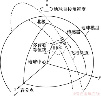
图1 像素定位的GEI坐标系
Fig. 1 GEI coordinate system of pixel geo-location
式中:λ为雷达波长;fd为多普勒频率;vS和vT分别为传感器和目标点的速度矢量。
地球模型方程可以用1个扁椭球体来近似表达:
 (3)
(3)
式中:Re为赤道处的地球半径;h为目标高程;Rp为极地半径;(xt,yt,zt)为目标点位置矢量在GEI坐标系中的3个分量。
影像SAR像素几何定位精度的主要因素有:地球椭球模型的有效性、卫星轨道参数的精度、目标点的高程精度。
从式(1)和式(2)可以看出:轨道对定位精度有影响,可以通过地面控制点对其进行消除。
从式(3)可以看出:地形也是影响定位精度的一大因素。其具体的表达式为[14]
 (4)
(4)
式中:△p为平面位置误差;θ为雷达入射角;△h为高程误差。
本文采用TerraSAR干涉生成的DEM作为定位的高程起算值,其精度较高,从一定程度上削弱了地形对定位精度的影响。
式(3)中的(xt,yt,zt)是所需求解的未知量,模型解算一般采用迭代法求解[8-10, 17]。
2 相似转换模型
由于各种因素的影响,利用R/D几何定位模型获取的结果与真实结果之间存在一定的误差。为了提高SAR影像的几何定位精度,本文在R/D模型定位结果的基础上,利用相似转换模型来消除地形效应、轨道误差等因素对定位结果的影响。相似转换模型改正的基本原理如下。
对于影像上的1个像素,利用R/D几何定位模型获取的结果记为(xe,ye),而其真实坐标记为(xr,yr)。对于1个精确的定位模型,(xe,ye)与(xr,yr)应该相同。但实际上,由于地形效应、轨道误差等因素的影响,(xe,ye)与(xr,yr)之间存在差别,可以通过某些方法来缩小(xe,ye)与(xr,yr)之间的差别,也就是说提高其定位精度。这里采用相似转换模型来缩小这种差别,其模型可以表示为
 (5)
(5)
其中: 为平移参数;m为缩放参数;α为旋转参数;
 为坐标改正数。
基于最小二乘方法,通过一些地面控制点可以获取相似转换模型。通过获取的相似转换模型,可以提高R/D模型的几何定位精度。这种相似转换模型校正的具体实现过程如下。
(1) 通过R/D几何定位模型,得到每个点的坐标估计值(xe,ye)。
(2) 选择一些地面控制点(GCP),利用最小二乘方法获取模型参数,建立相似转换模。
(3) 利用建立的相似转换模型,改正其他点的R/D模型估计的坐标值。
3 实验及分析
3.1 实验数据及精度评价方法
实验数据为湖南冷水江地区两景TerraSAR影像,成像时间分别为2008-09-16和2008-09-27,实验区域的面积为5 km×10 km,其平均高程为600 m左右,地形起伏较大。在实验地区安装一系列角反射器,具体分布情况如图2所示。
图3所示为角反射器在影像上显示的效果放大图。从图3可以看到影像上的角反射器呈现1个亮“十”字形。采用静态相对定位的作业方式,共有4台中海达GPS接收机同时测量,由点CR01测往点CR09,都按照每次移动2台GPS接收机的边连式方式进行观测,即每个同步环能够完成2个点的观测,每个同步环观测不少于40 min,采样间隔为10 s,这样,就获取了每个角反射器的精确三维坐标,这为后面影像定位精度的评定提供了可信度。
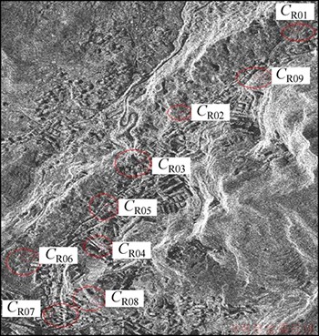
图2 TerraSAR影像及其角反射器
Fig. 2 TerraSAR image and corner reflectors
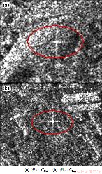
图3 角反射器在影像上的放大图
Fig. 3 Display effects of CR in images
产品的精度是根据计算值与真实值之间的差异进行估计的。采用均方根误差e对数据精度进行评定,其具体的表达式如下:
 (6)
(6)
其中:ZESTi和ZReali分别表示计算值与真实值。
3.2 实验
3.2.1 实验一:定位结果及精度
本实验选择冷水江地区2008-09-16 TerraSAR影像,中心经度为东经111.49°,中心纬度为北纬27.78°,分辨率为1 m,具体影像参数见表1。
表1 TerraSAR影像基本参数
Table 1 Basic parameters of TerraSAR image

利用R/D定位模型对影像像素进行定位,将得到的定位结果与地面控制点坐标进行比较,其坐标误差及其精度如表2所示。
表2 R/D定位模型结果及精度
Table 2 R/D model geo-location results and accuracy m
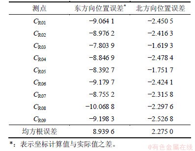
从表2可以看出:R/D定位模型在东方向和北方向的均方根误差分别为8.939 6 m和2.275 0 m。在没有经过地面控制点的校正精度接近于文献[10]中的定位精度,相对于中低分辨率SAR影像而言,定位精度得到了很大提高,这也说明高分辨率影像在定位方面具有很大优势。
利用相似转换模型以及CR1-CR4 4个地面控制点对CR5-CR9 5个CR点进行纠正,以提高其定位精度。将得到的定位结果与真实坐标值进行比较,其坐标误差及定位精度如表3所示。
表3 相似转换模型校正结果及精度
Table 3 Similar transformation model results and accuracy m
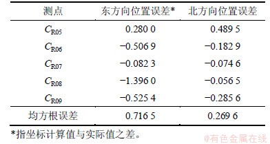
从表3可以看出:坐标经过相似转换模型校正以后,定位精度得到了很大提高,在东方向和北方向分别为0.716 5 m和0.269 6 m。这主要是由于相似转换模型大大减小了地形效应以及轨道等因素引起的误差。
3.2.2 实验二:定位结果及精度
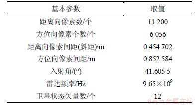
本实验选择冷水江地区2008-09-27 TerraSAR影像,中心经度为东经111.49°,中心纬度为北纬27.78°,分辨率为1 m。其具体的影像参数见表4。
表4 TerraSAR影像基本参数
Table 4 TerraSAR image basic parameters
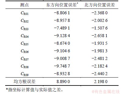
利用R/D定位模型对影像进行像素定位,将得到的定位结果与地面控制点坐标进行比较,其坐标误差及定位精度如表5所示。
从表5可以看出:R/D定位模型在东方向和北方向的均方根误差分别为8.890 0 m和2.198 0 m,与实验一结果比较接近。
表5 R/D几何定位模型结果及精度
Table 5 R/D model geo-location results and accuracy m
利用相似转换模型以及CR01~CR04 4个地面控制点对CR05~CR09 5个点进行纠正,将得到的定位结果与真实坐标值进行比较,其坐标误差及定位精度如表6所示。
表6 相似转换模型校正结果及精度
Table 6 Similar transformation geo-location results and accuracy m
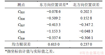
从表6可以看出:校正后的定位精度在东方向和北方向分别为0.613 0 m和0.237 0 m,与实验一的结果也比较接近。
3.3 分析与讨论
结合实验一和实验二结果可知:未经过基于地面控制点的相似转换模型校正之前,TerraSAR影像的定位精度在东方向和北方向分别为8.914 8 m和2.236 5 m,总的平面精度为9.191 1 m(取实验一与实验二结果的平均数),未达到1:50 000地形图5 m的平面精度要求。而经过相似转换校正之后,其定位精度得到了很大提高,在东方向和北方向均在1 m以内,完全满足1:50 000地形图的平面精度要求,甚至达到了1:10 000地形图的精度标准。
从以上2个实验结果还可以看出:北方向的定位精度要高于东方向的定位精度。这主要是由于地形效应对东方向的影响较大而产生的,也就是说,地形对距离向的定位误差有较大的影响。
经过相似转换坐标校正以后,其定位精度得到了明显提高。其主要原因有2个方面:(1) 地面控制点精度较高,达到分米级,能够减小轨道误差对定位精度的影响,从而有效地提高了最终的定位精度;(2) 地形是影响几何定位精度的又一因素,基于相似转换模型的坐标校正,可以在一定程度上削弱地形对定位精度的影响,从而有效地提高了定位精度。同时,在没有经过相似变换校正之前,在R/D模型方程(3)中的地形采用的是基于TerraSAR干涉技术生成的DEM,其精度达到5 m,与参考文献[3]中高程精度低于5 m以及参考文献[8]中使用高程为固定值0 m的结果相比,已大大削弱了地形效应对定位精度的影响。
比较实验一和实验二的结果可以看出最终的定位精度比较接近,这也说明本文所采用方法具有较强的稳健性,对定位精度的提高具有较高的实用价值。
4 结论
(1) 本方法通过补偿地形效应和轨道的影响大大提高了影像的定位精度,改进后的平面精度在东方向和北方向分别为0.664 8 m和0.253 3 m,完全满足 1:50 000地形图的要求,甚至达到了1:10 000地形图的标准。
(2)采用TerraSAR InSAR技术生成的高精度DEM,结合R/D模型进行地理定位得到了较好结果,这也进一步说明地形对定位精度的影响是比较大的。
(3) 本文采用的方法具有较强的稳健性,这也从另一方面证明了本文提出的改进算法是行之有效的,对西部1:50 000甚至1:10 000地形图的获取具有较高实用价值。
致谢:感谢德国GFZ中心夏耶教授提供的TerraSAR数据。
参考文献:
[1] Curlander J C. Location of pixels in spaceborne SAR imagery[J]. IEEE Transactions on Geoscience and Remote Sensing, 1982, 20(3): 359-364.
[2] Curlander J C, McDonough R N. Synthetic aperture radar, system and signal processing[M]. New York: John Wiley & Sons, 1991: 372-387.
[3] Mohr J J, Madsen S N. Geometric calibration of ERS satellite SAR images[J]. IEEE Transactions on Geoscience and Remote Sensing, 2001, 39(4): 842-850.
[4] 周金萍, 唐伶俐, 李传荣. 星载SAR图像的两种实用化R-D定位模型及其精度比较[J]. 遥感学报,2001, 5(3): 191-197.
ZHOU Jinping, TANG Lingli, LI Chuanrong. Development of two practical R-D location models and precision comparison between them[J]. Journal of Remote Sensing, 2001, 5(3): 191-197.
[5] 张永红, 张继贤, 林宗坚. SAR影像几何校正[J]. 测绘学报, 2002, 31(2): 134-138.
ZHANG Yonghong, ZHANG Jixian, LIN Zongjian. SAR image rectification[J]. Acta Geodaetica et Cartographica Sinica, 2002, 31(2): 134-138.
[6] 张永红, 张继贤, 杨崇源. 基于影像模拟的SAR几何校正准自动方法[J]. 遥感学报, 2003, 7(2): 106-111.
ZHANG Yonghong, ZHANG Jixian, YANG Chongyuan. A quasi-automatic rectification method of sar image based on image simulation[J]. Journal of Remote Sensing, 2003, 7(2): 106-111.
[7] Liu H, Zhao Z, Jezek K C. Correction of positional errors and geometric distortions in topographic maps and DEMs using a rigorous SAR simulation technique[J]. Photogrammetric Engineering and Remote Sensing, 2004, 70(9): 1031-1042.
[8] 陈尔学, 李增元. ENVISAT ASAR影像几何定位方法研究[J]. 中国图象图形学报, 2004, 9(8): 991-996.
CHEN Erxue, LI Zengyuan. Study on ENVISAT ASAR image geolocation method[J]. Journal of Image and Graphics, 2004, 9(8): 991-996.
[9] 陈尔学. 星载合成孔径雷达影像正射纠正方法研究[D]. 北京: 中国林业科学研究院, 2004: 60-72.
CHEN Erxue. Study on ortho-rectification methodology of space-borne synthetic aperture radar imagery[D]. Beijing: Chinese Academy of Foresty, 2004: 60-72.
[10] 陈尔学, 李增元. 分析法和数值解算法相结合的星载SAR直接定位算法[J]. 中国图象图形学报, 2006, 11(8): 1105-1109.
CHEN Erxue, LI Zengyuan. Space-borne SAR geolocation algorithm integrating pure analysis and numerical geo-location methods[J]. Journal of Image and Graphics, 2006, 11(8): 1105-1109.
[11] Zhang L, Balz T, Liao M S. Satellite SAR geocoding with refined RPC model[J]. ISPRS Journal of Photogrammetry and Remote Sensing, 2012, 69: 37-49.
[12] 魏钜杰, 张继贤, 黄国满, 等. TerraSAR-X影像直接地理定位方法研究[J]. 测绘通报, 2009, 9(11): 11-14.
WEI Jujie, ZHANG Jixian, HUANG Guoman, et al. Research on methods of TerraSAR-X image direct geolocation[J]. Bulletin of Surveying and Mapping, 2009, 9(11): 11-14.
[13] 魏钜杰, 张继贤. 面向西部测图困难地区稀少控制点下的TerraSAR-X影像快速正射纠正[J]. 遥感引用, 2010(3): 43-49.
WEI Jujie, ZHANG Jixian. Quick ortho-rectification of TerraSAR-X Image with sparse control for mapping difficulty area in the west region of China[J]. Remote Sensing Application, 2010(3): 43-49.
[14] 张过, 墙强. 基于影像模拟的星载SAR影像正射纠正[J]. 测绘学报, 2010, 39(6): 554-560.
ZHANG Guo, QIANG Qiang. Ortho-rectificaton of satellite-borne SAR image based on image simulation[J]. Acta Geodaetica et Cartographica Sinica, 2010, 39(6): 554-560.
[15] Hu H P, Kang C H. Equivalence analysis of accuracy of geolocation models for spaceborne InSAR[J]. IEEE Transactions on Geoscience and Remote Sensing, 2010, 48(1): 480-490.
[16] Brown W E. Applications of SEASAT SAR digitally correlated imagery for sea ice dynamics. presented at Amer[C]//Geophys Union Spring 1981 Meet. American, 1981: 25-29.
[17] 刘国祥, 丁晓利. 星载SAR复数图像的配准[J].测绘学报, 2001, 30(1): 60-66.
LIU Guoxiang, DING Xiaoli. Co-registration of satellite SAR complex images[J]. Acta Geodaetica et Cartographica Sinica, 2001, 30(1): 60-66.
(编辑 陈灿华)
收稿日期:2012-10-12;修回日期:2012-12-23
基金项目:国家自然科学基金资助项目(40974006,40774003);教育部新世纪优秀人才支持计划项目(NECT-08-0570);国家西部1:50 000空白区测图工程(2007年);湖南省高校创新平台项目(09K005,09K006)
通信作者:杨亚夫(1979-),男,湖南南县人,博士研究生,从事InSAR数据处理研究;电话:13507479653;E-mail:yangyafu@csu.edu.cn

