Application of wide-field electromagnetic method in shale gas survey in Eastern Kunlun, Qinghai province, China
来源期刊:中南大学学报(英文版)2020年第11期
论文作者:严玲琴 喻忠鸿 才智杰 王金海 徐永锋 林佳富 马龙
文章页码:3388 - 3397
Key words:wide field electromagnetic method; shale gas; Eastern Kunlun; Babaoshan Basin
Abstract: In order to study the distribution of shale gas reservoir in the Babaoshan Basin of Eastern Kunlun, the wide-field electromagnetic (WFEM) survey was carried out to obtain the spatial distribution characteristics of the underground electrical volume resistivity based on the delineation of the scope of the Babaoshan Basin by regional gravity data. The basic characteristics of the basement, basin framework, and extension, vertical change, burial depth of dark mud shale in this area were identified, and the electrical distribution of the Babaoshan mud shale horizon was revealed, which has been proved to be a good geological effect by drilling. The exploration results show that the WFEM has significant effects on the exploration of shale gas occurrence strata, which meets the needs of investigation and evaluation of multi-layered and large-scale shale gas, and plays a good demonstration role in the follow-up shale gas exploration.
Cite this article as: YU Zhong-hong, YAN Ling-qin, CAI Zhi-jie, WANG Jin-hai, XU Yong-feng, LIN Jia-fu, MA Long. Application of wide field electromagnetic method in shale gas survey in Eastern Kunlun, Qinghai province, China [J]. Journal of Central South University, 2020, 27(11): 3388-3397. DOI: https://doi.org/10.1007/s11771-020- 4554-0.

J. Cent. South Univ. (2020) 27: 3388-3397
DOI: https://doi.org/10.1007/s11771-020-4554-0

YU Zhong-hong(喻忠鸿)1, YAN Ling-qin(严玲琴)2, CAI Zhi-jie(才智杰)1, WANG Jin-hai(王金海)1,XU Yong-feng(徐永锋)3, 4, LIN Jia-fu(林佳富)1, MA Long(马龙)1
1. The Third Geological Exploration Institute of Qinghai Province, Xi’ning 810000, China;
2.Qinghai Geological Survey, Xi’ning 810000, China;
3. The Fourth Geological Exploration Institute of Qinghai Province, Xi’ning 810000, China;
4. Key Laboratory of Shale Gas Resources of Qinghai Province, Xi’ning 810000, China
 Central South University Press and Springer-Verlag GmbH Germany, part of Springer Nature 2020
Abstract: In order to study the distribution of shale gas reservoir in the Babaoshan Basin of Eastern Kunlun, the wide-field electromagnetic (WFEM) survey was carried out to obtain the spatial distribution characteristics of the underground electrical volume resistivity based on the delineation of the scope of the Babaoshan Basin by regional gravity data. The basic characteristics of the basement, basin framework, and extension, vertical change, burial depth of dark mud shale in this area were identified, and the electrical distribution of the Babaoshan mud shale horizon was revealed, which has been proved to be a good geological effect by drilling. The exploration results show that the WFEM has significant effects on the exploration of shale gas occurrence strata, which meets the needs of investigation and evaluation of multi-layered and large-scale shale gas, and plays a good demonstration role in the follow-up shale gas exploration.
Key words: wide field electromagnetic method; shale gas; Eastern Kunlun; Babaoshan Basin
Cite this article as: YU Zhong-hong, YAN Ling-qin, CAI Zhi-jie, WANG Jin-hai, XU Yong-feng, LIN Jia-fu, MA Long. Application of wide field electromagnetic method in shale gas survey in Eastern Kunlun, Qinghai province, China [J]. Journal of Central South University, 2020, 27(11): 3388-3397. DOI: https://doi.org/10.1007/s11771-020- 4554-0.
1 Introduction
Apart from North America, China is the first country to discover shale gas in the world, and the third country to realize the industrial production of shale gas after the United States and Canada [1, 2]. The research shows that China has abundant shale gas resources and has great development prospects [3]. Compared with North American Platform Shale gas reservoirs, the geological conditions for the formation and enrichment of shale gas are very complicated in China, so it’s of great practical significance to study the spatial distribution of reservoir basins and organic-rich shale by geophysical techniques [4]. Seismic exploration technology is widely used in shale gas exploration. In recent years non-seismic technology has also received increasing attention from researchers [5, 6]. Due to the advantages of strong anti- interference ability, high efficiency, high accuracy, low cost, and immense exploration depth, wide field electromagnetic (WFEM) has been widely used in shale gas exploration and achieved a series of promising results [7-11].
As part of the Qinghai-Tibet Plateau, Qinghai Province is located in the middle of the “Tethys” oil and gas focus zone, and has good oil and gas-forming conditions [12]. There are four sets of main source rocks in the province: Carboniferous, Permian, Triassic, and Jurassic, which are rivers and lakes or coastal peat marsh deposition systems. The source rock series formed in different geological periods are distributed unevenly throughout the whole province. The thickness of Middle Lower Jurassic is 30-763.4 m, that of the Upper Triassic is 166-1466.31 m, and the Carboniferous is 431.4-2264.91 m. The proportion of dark shale in the formation is between 51.69% and 94.33%, which ensures the minimum enrichment thickness of the shale section or the minimum thickness required for evaluation [13].
Qinghai province has conducted shale gas survey since 2013 and achieved some preliminary results in the Qaidam Basin. Studies show that the shale gas in the Qaidam Basin has great potential, and the shale gas geological resources and recoverable resources in this basin were determined to be 2.72×10¹² m3 and 0.56×10¹² m3 respectively, which indicates a good prospect of shale gas exploration and development in this region [14].
Through the evaluation of the shale gas resource potential in Qinghai province [15], 16 shale gas prospects and 7 shale gas favorable areas were selected, and the Babaoshan basin is one of them.
In 2017, the first shale gas survey was conducted in Babaoshan area of East Kunlun in the southern Qaidam basin, and Babaoshan formation is the target of this work. Organic-rich mud shale occurred in the upper (T3bb3) and lower (T3bb1) section of the Babaoshan formation is the main source rock series in the study area. WFEM method was used to comprehensively understand the basin framework, basement characteristics, and strike extension, vertical change and burial depth of dark shale, which provides important geological and geophysical information for determining favorable shale gas reservoir.
2 Geological and geophysical setting
The Babaoshan basin is located in the hinterland of the eastern Kunlun mountains in the central part of Qinghai province, south of the main ridge of Burhan Buda mountains. It is a narrow basin sandwiched between the Central and Southern fault zone of the Eastern Kunlun (Figure 1) [17]. The main strata involved in WFEM work are the early-middle Triassic stratum Hongshuichuan formation (T1-2h), Late Triassic Babaoshan formation (T3bb), and early-middle Jurassic Yangqu formation (J1-2yq) (Figure 2). The main gas-bearing stratum is Babaoshan formation stratum (T3bb), with a thickness more than 1500 m. The lithology is composed of sandy shale, coarse sandstone, medium sandstone, fine sandstone, andesite, mainly composed of thick sandstone and dark mud shale, with few carbonaceous shale and coal line. The shale is rich in plant fossils. Organic-rich mud shale occurs in the upper (T3bb3) and lower (T3bb1) section of Babaoshan formation.
Previous studies show that [17]: the average total organic carbon content (TOC) of dark shale in Babaoshan formation is 2.79%, which is good source rock; organic matter type is (humic type) III; the average of organic matter in mature stage (Ro) is 2.95%, which is high mature stage in the thermal evolution process. The development degree of porosity in Babaoshan formation is medium-good, and the deposition environment is river-lake sedimentary system.
The statistical results of the lithologic and electrical parameters of the main strata in Babaoshan are shown in Table 1. The Yangqu formation shows medium-resistivity, between 100 and 400 Ω・m. Resistivity of Babaoshan formation is relatively low, generally less than 100 Ω・m, shown as relatively low resistance; resistivity of the Naocangjiangou formation and Hongshuichuan formation is more than 400 Ω・m, generally in the thousands, shown as relatively high resistance. The main gas-bearing layer (Babaoshan formation) is characterized by low-resistance anomaly when the overlying stratum is sandstone of the Yangqu formation and the underlying stratum is limestone of the Naocangjiangou formation oresite or tuff and andesite of the Hongshuichuan formation. The difference of resistivity between different strata provides a good geophysical premise for WFEM in this area.
According to the residual gravity anomalies data with ratio of 1:200000 (Figure 3), the entire study area is located in a negative anomaly area, showing the characteristics of basin structural anomalies. There are two obvious negative anomaly zones in the east and west of the study area, which are inferred to be two sub-basins of the basin. The western low-gravity anomaly zone with lower anomaly amplitude shows a long axis in the east-west direction, so it is speculated that the basement of the western basin is buried relatively deep. The northern boundary of the study area is located in the anomalous step zone with northern high residual gravity and southern low residual gravity, with a large gradient, showing the characteristics of near east-west trending faults, which corresponds to the known fault zones.
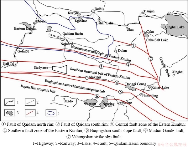
Figure 1 Sketch map of tectonic units of the eastern segment in the eastern Kunlun orogenic belt and adjacent area:

Figure 2 Map of geology and WFEM work layout of Babaoshan area:
Table 1 Statistical table of lithological and electrical properties of main strata

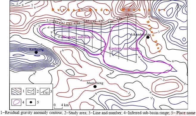
Figure 3 Contour map of 1:200000 residual gravity anomaly of Babaoshan area:
3 Principle and effectiveness analysis
Wide-field Electromagnetic method is an artificial source frequency-domain electromagnetic sounding method proposed by Academician HE Ji-shan [8]. It strictly defines a formula applicable to the entire domain to calculate apparent resistivity.
The strict and accurate expression of Ex of the horizontal dipole source on the uniform earth surface is as follows:
 (1)
(1)
and wide-field apparent resistivity is defined as:
 (2)
(2)
where I is the supply current; dL is the length of the electric dipole source; i is a pure imaginary number; k is a wave number in a uniform half-space; r is a transmitting and receiving distance, that is, the distance from the observation point to the center of the dipole; σ is the conductivity; φ is the angle between the source direction of the electric dipole and the vector diameter from the middle point of the source to the receiving point; ΔVMN is the observed potential difference; MN is the measurement electrode distance; KE-Ex is the device coefficient; FE-Ex is the electromagnetic response function.
Based on the physical parameters and geological background, we modeled the geological- geophysical condition of the study area (Figure 4): the first layer is the sandstone of the Yangqu formation, thickness of 600 m, resistivity of 300 Ω・m; the second layer is fine sandstone and andesite in the middle and upper section of Babaoshan formation, thickness of 350 m, resistivity of 150 Ω・m; the third layer is sandstone and sandy shale in the lower section of the Babaoshan formation, thickness of 600 m, resistivity of 80 Ω・m with high carbonaceous, and resistivity of 200 Ω・m without carbonaceous shale;the bottom layer is the volcanic rocks of the Hongshuichuan formation with resistivity of 1000 Ω・m.
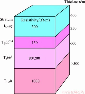
Figure 4 Geological and geophysical forward model diagram
The forward program is Data Processing and Interpretation Integrated Platform provided by Hunan Geosun Hi-technology Co., Ltd. The forward calculation method in the program was developed by LI [18]. The solid and dotted lines in Figure 5(a) are the apparent resistivity curve of the shale without carbonaceous mud and with the carbonaceous shale, respectively. The comprehensive resistivity of carbonaceous formation is characterized by low resistivity, and the frequency of entering the transition field is low. It can be seen from Figure 5(a) that there is almost no difference between the two curves before the skin depth reached the lower section of Babaoshan formation, but there is a significant difference of the maximum anomaly of 50% (Figure 5(b)) after reaching the skin depth frequency. This indicates that WFEM can be used to identify whether the lower section of Babaoshan contains carbonaceous mud shale.

Figure 5 Apparent resistivity curve and abnormal amplitude:
4 Data collection, processing and inversion
4.1 Data collection
The layout of WFEM survey line is shown in Figure 2. There are 10 parallel NS survey lines in total, the line distance is 4 km, and the basic point distance is 200 m (Six infill points on both sides of well Baye 1, with a distance of 100 m), with a total length of 146.6 km and 749 measuring points. The JSGY-2 WFEM instrument of Hunan Geosun Hi-technology Co., Ltd. is used in the field work, with operating frequency range of 0.0117-8192 Hz.
The power supply mode is limited long line power supply, and the electric field of Ex component is measured. The length of AB electrode is about 1 km, between the receiving and transmitting distance is 15-21 km, the grounding resistance is less than 12 Ω, the power supply voltage is 900 V, and the power supply current is more than 75 A.
4.2 Data processing
There is no human activity in this area, and almost no human electromagnetic interference, so the overall data quality is high. Before data inversion, only very few individual data were denoised, statically corrected and filtered.
4.3 Data inversion
WFEM was first carried out on the CX10 section with known boreholes. A three-layer geoelectric model was initially established by studying the electrical distribution characteristics of the original curve and combining the geological information exposed by the known borehole. It lays a good foundation for the quantitative inversion imaging. One-dimensional and two-dimensional inversions are carried out in this inversion work, both of which use continuum models. One- dimensional inversion is a method of data fitting by solving the generalized inverse to obtain the least square solution; the two-dimensional inversion takes the one-dimensional inversion results as the initial model; and the inverse calculation is performed by the nonlinear conjugate gradient method.
5 Interpretation of results
5.1 CX10 section
CX10 is located in the east of the study area and arranged on the Baye 1, with a section length of 21 km. The borehole is located at the point 300 of the profile. According to the histogram and inversion cross section of the Baye 1 (Figure 6, part of line CX10), the borehole shows a low resistance anomaly from shallow to deep, and the apparent resistivity is less than 250 Ω・m from shallow to 550 m, which reflects the lower section of Babaoshan formation (T3bb1). The low resistance indicates that organic matter content is rich in this formation, in which 310-560 m is the main gas-bearing section revealed by drilling. It can be seen that the resistivity is the lowest at the deep part of the gas-bearing sections, which fully proves that WFEM can recognize organic-rich horizons. There are moderate resistance anomalies on both sides of the borehole, and the resistivity is 250-1000 Ω・m, which is interpreted as the middle section of Babaoshan formation (T3bb2). The resistivity increases to more than 400 Ω・ m at about 570 m in the inversion section, reflecting the volcanic strata of the Hongshuichuan formation (T1-2h). The middle and upper Babaoshan formation (T3bb2-3) in the shallow part of Baye 1 is only 20 m thick, so it is not reflected in this two- dimensional inversion.
5.2 CX8 section
According to the results of the CX8 two- dimensional inversion (Figures 7, part of line CX8), there are obvious difference in resistivity from shallow to deep layers, and they can be roughly divided into three electrical layers.
The first layer: The resistivity is generally 50-700 Ω・m, and the bottom depth of the layer is mostly 1000-1600 m. There are two sublayers in the medium resistance area with resistivity of 250-700 Ω・m. The shallow bottom plate is buried at 200-600 m, with continuous anomalies of medium resistivity, which is inferred as the Yangqu formation (J1-2yq). The upper and lower sections of the Yangqu formation have little electrical difference, so there is no abnormal display on the section. The medium resistance layer with buried depth of the lower roof of 900-1100 m is caused by the middle section of Babaoshan formation (T3bb2), and the continuity of this section is poor. The resistivity of the upper section of Babaoshan formation (T3bb3) between Yangqu formation and middle Babaoshan formation is 50-250 Ω・m, which is relatively low. The thickness of T3bb3 is approximately between 500-800 m, with good continuity.
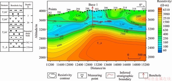
Figure 6 Stratum depth of Baye 1(left) and WFEM inversion section of line CX10 in Babaoshan area (partial, right)

Figure 7 Stratum depth of Baye 2(left) and WFEM inversion section of line CX8 in Babaoshan area (partial, right)
The second layer: there is an obvious low resistivity layer in the buried depth of 1200-2000 m, and the resistivity is less than 100 Ω・m, which is inferred to be interpreted as the lower section of Babaoshan formation (T3bb1). The layer with large and stable thickness has good continuity in NS direction, and is not closed in the south and north ends. The burial depth of the floor of this layer is 1500-2000 m and the thickness is 600-800 m.
The third layer: There is an obvious resistivity step transition zone at the buried depth of about 1800 m below the low resistance layer. The resistivity value in the high resistance area is more than 300 Ω・m, mostly varying from 600 Ω・m to 3500 Ω・m. According to the CX10 line and the Baye 1, the Naocangjiangou formation in the deep is not considered and it is interpreted as the volcanic rock of the Hongshuichuan formation.
Based on the results of WFEM inversion, Baye 2# was deployed at point 288 of the CX8 line for verification, and gas was successfully found in the sandstone and mud shale at the bottom of Yangqu formation and the upper and lower sections of Babaoshan formation. According to the cross- sectional view of resistivity of line CX8 (Figure 7), the resistivity at point 288 can be divided into five electrical layers, which are medium-high, medium- low, medium, low and high, respectively corresponding to sand and conglomerate of Yangqu formation, sandstone of upper Babaoshan formation, andesite of middle Babaoshan formation, sandstone, shale and volcanic rock of lower Babaoshan formation. Figure 7 shows the inferred and real floor depth of each layer. There is little difference among the stratum electrical parameters of Yangqu formation, Naocangjiangou formation and Hongshuichuan formation, and the electrical anomalies are not obvious, so they cannot be distinguished on the resistivity section. The resistivity log curve is consistent with the change trend of the section, which proves the reliability of WFEM inversion results.
Through the comparison of horizons and boreholes, it can be inferred that WFEM has better effect identifying the deep strata, and the depths of the geological horizons are more consistent with actual conditions. The main target strata in the upper and lower sections of Babaoshan formation show obvious low resistance anomalies.
5.3 Interpretation of main gas-bearing horizons
Based on the comprehensive interpretation of known borehole data and WFEM cross-sections (Figure 8), the low-resistance anomalous zone in the study area is analyzed, which is equivalent to the inferred spatial distribution of the main gas-bearing horizons of the Babaoshan formation, and the geological framework of the basin is inferred from the depth data of each horizon.
The main gas-bearing strata in the study area are the upper (T3bb3) and lower (T3bb1) sections of Babaoshan formation. According to the interpretation of 10 WFEM cross-sections, the two sets of strata are distributed from CX1 to CX10. The depth contour map (Figure 9) shows that the depth of the T3bb1 floor (top of basement) is deep in the east/west and shallow in the central, corresponding to the geological framework of depression in the east/west and uplift in the central, and the basin basement is Naocangjiangou formation and Hongshuichuan formation of Triassic. The depth values of the floor of T3bb1 in the east/ west depressions and central uplift are 1600-2000 m and 900-1000 m, respectively, which is consistent with the geological framework inferred from gravity.
The lower section of Babaoshan formation (T3bb1) has good stability, showing large thicknesses in the east/west and small thickness in the central. The thickness of T3bb1 is generally 500-700 m in the east/west, more than 700 m in the southeast of the survey area, and 150-300 m in the central uplift (CX4, CX5, CX6 positions). The resistivity of T3bb1 is less than 100 Ω・m generally, and less than 50 Ω・m in some regions.

Figure 8 3D display of resistivity section of WFEM in Babaoshan area

Figure 9 Contour map of T3bb1 bottom boundary depth
The stability of the upper section of Babaoshan formation (T3bb3) is poor compared with T3bb1. The thickness of CX4, CX6 and CX10 lines is generally 500-800m, and less than 300m in some regions. The resistivity of T3bb3 is more than 100 Ω・m in the central uplift (exceeds 200 Ω・m in some regions) and generally 50-200 Ω・m in the eastern/western depressions, which is higher than that of T3bb1.
6 Conclusions
The spatial information of the target horizon can be provided from the two dimensions of plane and depth through the comprehensive analysis of the various geological geophysical data.
The electrical characteristics and spatial distribution range of shale are roughly identified from the depth dimension through WFEM work. As the main gas-bearing strata, Babaoshan formation is rich in the organic matter, and it has obvious characteristics of low resistance, indicating that WFEM can identify the target stratum effectively. This study provides a good reference for shale gas exploration in areas with similar geological background areas.
Acknowledgement
This study was specifically funded by the “Qinghai Scholars”, and all authors are grateful for this. Thanks to the review experts for their valuable comments.
Contributors
YU Zhong-hong carried out comprehensive research and manuscript writing. YAN Ling-qin compiled and revised the manuscript. CAI Zhi-jie undertook the data analysis work. XU Yong-feng provided geological data. WANG Jin-hai was responsible for the management work. LIN Jia-fu and MA Long conducted data collection and processing. All authors have read and approved the final manuscript.
Conflict of interest
YU Zhong-hong, YAN Ling-qin, CAI Zhi-jie, WANG Jin-hai, XU Yong-feng, LIN Jia-fu and MA Long declare that they have no conflict of interest.
References
[1] DONG Da-zhong, ZOU Cai-neng, YANG Hua, WANG Yu-man, LI Xin-jing, CHEN Geng-sheng, WANG Shi-qian, LU Zong-gang, HUANG Yong-bin. Progress and prospects of shale gas exploration and development in China [J]. Acta Petrolei Sinica, 2012, 33(S1): 107-114. DOI: 10.7623/ syxb2012S1013. (in Chinese)
[2] DONG Da-zhong, ZOU Cai-neng, DAI Jin-xing, HUANG Shi-peng, ZHENG Jun-wei, GONG Jian-ming, WANG Yu-man, LI Xin-jing, GUAN Quan-zhong, ZHANG Chen-chen, HUANG Jin-liang, WANG Shu-fang, LIU De-xun, QIU Zhen. Suggestions on the development strategy of shale gas in China [J]. Natural Gas Geoscience, 2016, 27(3): 397-406. DOI: 10.11764/j.issn.1672-1926.2016.03. 0397. (in Chinese)
[3] DONG Da-zhong, WANG Yu-man, LI Xin-jing, ZOU Cai-neng, GUAN Quan-zhong, ZHANG Chen-chen, HUANG Jin-liang, WANG Shu-fang, WANG Hong-yan, LIU Hong-lin, BAI Wen-hua, LIANG Feng, LIN Wen, ZHAO Qun, LIU De-xun, QIU Zhen. Breakthrough and prospect of shale gas exploration and development in China [J]. Natural Gas Industry, 2016, 36(1): 19-32. DOI: 10.3787/j.issn.1000-0976.2016.01.003. (in Chinese)
[4] WANG Dao-fu, GAO Shi-kui, DONG Da-zhong, HUANG Xu-nan, WANG Yu-man, HUANG Jin-liang, WANGShu- fang, PU Bo-ling. A primary discussion on challenges for exploration and development of shale gas resources in China [J]. Natural Gas Industry, 2013, 33(1): 8-17. DOI: 10.3787/ j.issn.1000-0976.2013.01.002. (in Chinese)
[5] YUAN Gui-qin, SUN Yue, GAO Wei-dong, SHI Xu-dong, WANG Ying-xiu. Development status of the shale gas geophysical prospecting technology [J]. Geology and Exploration, 2013, 49(5): 945-950. (in Chinese)
[6] LIU Zhen-wu, SA Li-ming, YANG Xiao, LI Xiang-yang. Needs of geophysical technologies for shale gas exploration [J]. Oil Geophysical Prospecting, 2011, 46(5): 810-818. DOI: 10.13810/j.cnki.issn.1000-7210.2011.05.023. (in Chinese)
[7] HE Ji-shan. Wide field electromagnetic sounding methods [J]. Journal of Central South University (Science and Technology), 2010, 41(3): 1065-1072. (in Chinese)
[8] HE Ji-shan, LI Di-quan, DAI Shi-kun. Shale gas detection withwide field electromagnetic method in North-western Hunan [J]. Oil Geophysical Prospecting, 2014, 49(5): 1006-1012, 824. DOI: 10.13810/j.cnki. issn.1000-7210.2014. 05.052. (in Chinese)
[9] LING Fan, ZHU Yu-zhen, ZHOU Ming-lei, TIAN Hong-jun. Shale gas potential assessment of Changsan uplift area in southern North China basin by using wide field electromagnetic method [J]. Geophysical and Geochemical Exploration, 2017, 41(2): 369-376. (in Chinese)
[10] ZHANG Qiao-xun, LI Di-quan, TIAN Mao-jun. Application of wide field electromagnetic method to the hydrocarbon exploration in a basin of South Jiangxi [J]. Oil Geophysical Prospecting, 2017, 52(5): 1085-1092. DOI: 10.13810/j.cnki. issn.1000-7210.2017.05.023. (in Chinese)
[11] ZHENG Bing, LI Di-quan. Comparative test of wide field electromagnetic method and MT at a shale gas block in the south of China [J]. Petroleum Geophysics, 2015, 13(3): 45-49. (in Chinese)
[12] QIN Jian-zhong. Depositional environment of the marine hydrocarbon source rock in the Qiangtang basin, Qinghai- Tibet plateau [J]. Petroleum Geology & Experiment, 2006, 28(1): 8-14, 20. DOI: 10.11781/sysydz200601008. (in Chinese)
[13] PAN Tong, WANG Jun. Prospects of shale gas development in Qinghai Province [J]. Qinghai Science and Technology, 2018, 25(6): 4-7. DOI: 10.3969/j.issn.1005-9393.2018.06. 001. (in Chinese)
[14] HOU Hai-hai, SHAO Long-yi, LI Yong-hong, LI Zhen, ZHANG Wen-long, WEN Huai-jun. The pore structure and fractal characteristics of shales with low thermal maturity from the Yuqia Coalfield, northern Qaidam Basin, northwestern China [J]. Frontiers of Earth Science, 2018, 12(1): 148-159. DOI: 10.1007/ s11707-016-0617-y.
[15] XU Yong-feng, CHEN Jian-zhou, SONG Wei-gang, GONG Zhi-yuan. Evaluation of shale gas potential in Qinghai Province [R]. Xining: The Fourth Geological Exploration Institute of Qinghai Province, 2015. (in Chinese)
[16] LIU Tu-jie. The eastern section of the southern slope of Flood river group geological characteristics, the East Kunlun orogenic belt provenance and tectonic significance [D]. Xi’an: Chang’an University, 2015: 10-12. http://web02. cnki.net/KCMS/detail/detail.aspx?dbcode=DKCM&dbname=DKCTLKCMFD201601&filename=1015802574.NH&. (in Chinese)
[17] HE Ling-xiong, SONG Wei-gang, AN Sheng-ting, XU Yong-feng, SHEN Juan, LU Chao, WANG Jun. Structural evolution and organic geochemical characteristics of source rocks in the Babaoshan Basin in eastern Kunlun area, Qinghai Province [J]. Natural Gas Geoscience, 2018, 29(4): 538-549. DOI: 10.11764/j.issn.1672-1926.2018.03.005. (in Chinese)
[18] LI Di-quan, XIE Wei, DI Qing-yun, WANG Miao-yue, Forward modeling for “earth-ionosphere” mode electro- magnetic field [J]. Journal of Central South University, 2016, 23(9): 2305-2313. DOI: 10.1007/s11771-016-3288-5.
(Edited by YANG Hua)
中文导读
广域电磁法在青海省东昆仑页岩气调查评价中的应用
摘要:为了研究东昆仑八宝山盆地页岩气储层的分布规律,开展了广域电磁法探测工作,获得了盆地内地下电性体电阻率空间分布特征,基本查明了该区基底特征、盆地格架、暗色泥页岩的走向延伸、垂向变化、埋藏深度等,揭示了八宝山泥页岩层位的电性分布规律,经钻探验证取得了很好的地质效果。勘探结果表明:广域电磁法成果对探测页岩气赋存地层效果显著,满足了八宝山多层系、大面积的页岩气调查评价需要,为后续开展页岩气勘查起到了很好的示范作用。
关键词:广域电磁法;页岩气;东昆仑;八宝山盆地
Foundation item: Project(2019-SF-141) supported by Science and Technology Program of Qinghai Province, China; Projects(2017042105kc055, 2017042014ky014) supported by Geological Exploration Foundation of Qinghai Province, China
Received date: 2020-01-02; Accepted date: 2020-07-24
Corresponding author: YAN Ling-qin, Senior Engineer; Tel: +86-13897467828; E-mail: 45061885@qq.com. OCRID: https://orcid.org/ 0000-0001-9244-6891

