Trans. Nonferrous Met. Soc. China 24(2014) 3309-3315
Evaluation of PS-DInSAR technology for subsidence monitoring caused by repeated mining in mountainous area
Zhen-guo LIU1, Zheng-fu BIAN1, Shao-gang LEI1, Dong-lie LIU1,2, Andrew SOWTER3
1. School of Environment Science and Spatial Informatics, China University of Mining and Technology, Xuzhou 221116, China;
2. Institute of Geodesy and Photogrammetry, TU Braunschweig,  3, Braunschweig D-38106, Germany;
3. Nottingham Geospatial Institute, University of Nottingham Innovation Park, Triumph Road, Nottingham NG7 2TU, UK
Received 10 July 2013; accepted 14 February 2014
Abstract:
The high resolution TerraSAR-X dataset was employed with DInSAR and persistent scatterer interferometry (PSI) technique for subsidence monitoring in a mountainous area. For DInSAR technique, the generally used SRTM and relief-DEM, which was derived from aerial topographic map, were used to evaluate the influence of external DEM. The results show that SRTM could not fully compensate the complex topography of the research area. The corner reflectors installed during the acquisition of SAR dataset were used to estimate the accuracy of geocoding. The terrain corrected geocoding results based on relief-DEM were much better than using SRTM, with the root mean square error (RMSE) being 6.35 m in X direction and 11.65 m in Y direction (both in UTM projection), around one pixel of the multilooked intensity image to be geocoded. For PSI technique, the results from time-series analysis of multi-baseline differential interferograms were integrated to restrict only persistent scatterer candidates near the boundary of subsiding area for regression analysis. The results demonstrate that PSI can refine the boundary of subsidence, which could then be used to derive some angular parameters to help people to learn the law of subsidence caused by repeated excavation in this area.
Key words:
DInSAR; geocoding; persistent scatterer interferometry (PSI); repeated excavation; corner reflector; subsidence monitoring;
1 Introduction
Differential interferometric synthetic aperture radar (DInSAR) has shown its effective application to land surface deformation monitoring. Persistent scatterer interferometry (PSI) was proposed to overcome the problem of de-correlation and atmospheric delay effect, which are the main limiting factors of conventional DInSAR technique. By performing analysis on a limited set of persistent scatterers (PS), which are inhomogeneously distributed, PSI could obtain the deformation parameters with higher accuracy. This accuracy is dependent on the number and the spatial and temporal distribution of the images available, and the kinematic characteristics of the deformation have been researched [1]. In the past 15 years, PSI technique has been proved successfully in deformation monitoring especially in the urban area [2-7]. The deformation therein caused usually by dewatering is linear and the buildings could guarantee the number and density of PS. What��s more, as the hotspot of spaceborne SAR platforms, the urban area possesses a large stack of archived SAR dataset. PSI technique has also been employed for subsidence monitoring in the mining area since 2005 and excellent results were obtained [8-13]. However, the typically high rate of subsidence and low density of detected PS could be the most important limiting factor that challenges PSI for a further promotion. Scarcity of enough SAR dataset is yet another dilemma.
In this work, both DInSAR and PSI technique were utilized with programmed high-resolution TerraSAR-X dataset to a mountainous area, which was seriously affected by underground coal mining activities. In our preliminary work [14], results from time-series DInSAR were used to derive some parameters, such as advanced influence angle, angle of subsidence and moving distance. These parameters are related to evolution of ground subsidence and could provide reference for mine companies when designing coal safety pillar to prevent structure from damages prior to mining from a safety point-of-view. Obviously, the accuracy of geocoding InSAR results into local coordinate system, and the precision of measured subsidence at the boundary of subsided area are two essential issues. In the following, the influence of external DEM, used to compensate topographic phase and geocoding during DInSAR processing, was analyzed. Based on the corner reflectors distributed over the research area, the performance of geocoding was also demonstrated. For PSI processing, the previously obtained time-series DInSAR results were brought together as apriori information: the identified extent of subsidence was used to mask out PS candidates (PSCs) undergoing serious subsidence, leaving only PSCs near the subsiding bounds for regression analysis.
2 Research area and acquired SAR dataset
2.1 Research area
The research area is located in Gujiao County, Taiyuan, Shanxi Province, China (Fig. 1). There are 5 active mines with a total coverage of 306 km2. Three-quarters of this area feature large mountains with steep slopes and ravines, which are mainly composed of carboniferous, Permian sandstone, shale and quaternary loess. The presence of extensive vegetation and very few man-made structures make this area a very challenging environment for InSAR techniques. Furthermore, repeated excavation is carried out in the lower coal seams since the upper seams will be exhausted soon. The red polygons in Fig. 1 show the extents of already mined-out area of upper coal seams, holding nearly half of the whole research area. It is predicted therefore that the repeated excavation will induce bigger and faster deformation than before, which needs more observations in the future to reveal the law of subsidence caused.
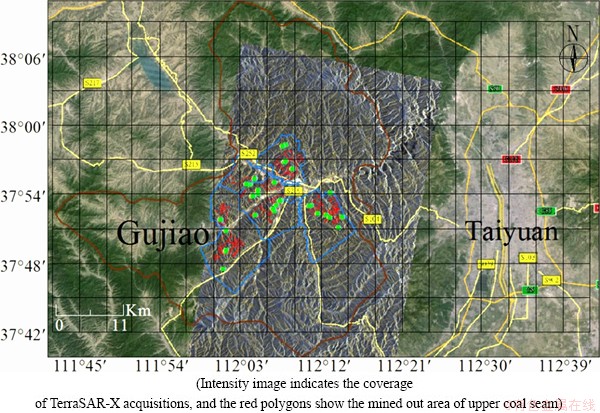
Fig. 1 Research area of Gujiao coal mines shown on Google Earth, Taiyuan, Shanxi Province
Table 1 Specifications of TerraSAR-X dataset acquired
2.2 SAR dataset acquisition
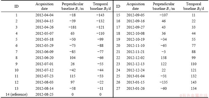
The TerraSAR-X data were programmed and ordered using the online system of DLR. Considering the seriously varied topography, the following descending scenes (Table 1) were programmed (from April 4, 2012 to January 26, 2013) with an incidence angle in the range of 24.77��-28.04�� (strip 005R) to reach a good compromise among the effects of shadowing, layover and foreshortening.
3 Data processing
Both DInSAR and PSI technique were utilized for TerraSAR-X dataset processing. However, for DInSAR technique, the generally used 3 arc-second SRTM [15] may not be able to fully compensate topography phase, especially for TerraSAR-X dataset, which has 2 m resolution. The large scale aerial topographic map was collected, organized and edited in ArcGIS to generate high-resolution digital elevation model (DEM), noted as relief-DEM. For DInSAR processing, we chose the first 3 images, acquired in April, 2012, to demonstrate the influence of external DEM. The images acquired in this month typically are of better quality for there is nearly no vegetation and snow coverage on the ground, which are the main factor of de-coherence in this area. Table 2 shows the specifications of the interferometry pairs used here.
Table 2 Specifications of interferometry combination for DInSAR

Geocoding is an important step for both DInSAR and PSI techniques. On one hand, the results from InSAR and PSI need to be geocoded to local coordinates, in order to interpret the corresponding phenomenon by integrating ground truth dataset; on the other hand, the external DEM, either obtained from local topographic map or SRTM, needs to be geocoded to radar coordinates. Thus, the accuracy of geocoding is rather essential and the evaluation is necessary. The simulated SAR image, generated based on the external DEM and SAR image geometry, was used to perform and refine terrain corrected geocoding. The accuracy evaluation will be involved in the next section using corner reflectors installed in the research area.
GAMMA interferometric point target analysis (IPTA) was used for PSI processing. Considering the fact that in the research area deformation caused by repeated coal mining is typically serious and nonlinear, the result from time-series analysis of multi-baseline differential interferograms was used. Figure 2 shows the accumulated deformation phase for mining face 18207 and the corresponding mask file, resulting in that only PS candidates (PSCs) near the boundary of subsidence (with relatively small deformation) remaining for IPTA regression analysis (Fig. 3). Furthermore, a small temporal baseline approach was applied when generating interferogram table. In our case, only pairs with intervals up to 44 d were considered, resulting in 55 combinations (Fig. 4). All these together could avoid too much phase change due to deformation over longer interval, which is conducive to phase unwrapping afterwards [11].
4 Results and analysis
4.1 DInSAR results with different external DEMs
Figure 5 shows the results of two-pass DInSAR overlaid with coal mining materials, utilizing SRTM and relief-DEM respectively. For the same interferometry pair (Figs. 5(a, c), Figs. 5(b, d)), we could see that results derived with relief-DEM are much better, although the maximum deformation measured looks more or less or the same. Since the research area was experiencing underground mining activities, subsidence should be the main form of ground deformation and can be easily located according to the theory of mining subsidence. Therefore, we could be sure that the uplifts in Fig. 5(b) should be due to uncompensated topographic phase, or external DEM error.
At the same time, from different interferometry pairs with the same external DEM (Figs. 5(a, b)), we could see that as the magnitude of perpendicular baseline increases, the uncompensated DEM error becomes more apparent. This clearly indicates that for deformation monitoring, SAR dataset with concentrated distribution of spatial baseline has much less strict requirements for external DEM, and thus is more preferred and qualified, especially for the mountainous area.
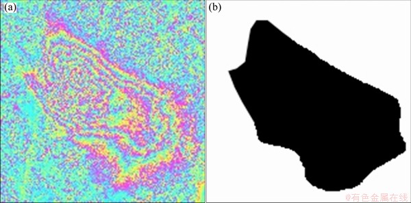
Fig. 2 Accumulated deformation phase for mining face 18207 during 2012-04-04 to 2013-01-26 (a), and mask file for PSI processing (b)
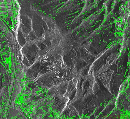
Fig. 3 Out-selected PSCs over 18207 after masking (In radar coordinates, two ellipses mark the position of corner reflectors installed)
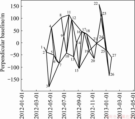
Fig. 4 Combination of interferograms for IPTA processing
4.2 Evaluation of geocoding performance
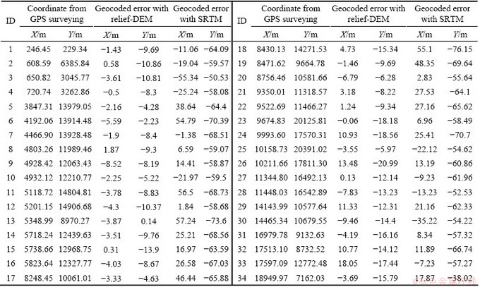
Before the acquisition of TerraSAR-X dataset, several corner reflectors (CRs, Fig. 6) were installed in the research area. The installed CRs, which represent themselves as bright points in SAR intensity images, could be recognized easily. Figure 7 shows two geocoded terrain corrected SAR intensity images over mining face 18207, based on relief-DEM and SRTM respectively. The two green points in Fig. 6 indicate the corresponding position of CRs obtained from GPS surveying. This in turn permits the quantitative evaluation of geocoding performance (Table 3).
From Fig. 7 and Table 3, we could see that geocoding with the help of relief-DEM performed much better. The corresponding root mean square error (RMSE) is 6.35 m in X direction and 11.65 m in Y direction, while for SRTM-based geocoding, the RMSE could reach up to 29.92 and 63.35 m, respectively. Note that the intensity image to be geocoded was multilooked with a factor of 5 in both range and azimuth direction, resulting in a 10 m��10 m resolution in ground range and azimuth direction. Thus, geocoding based on relief-DEM has higher accuracy, around one pixel. Even though this geocoding error of the final results could be mitigated using the georeferencing tool in GIS software with affine or polynomial transformation method, the topographic error caused by mismatch during geocoding the external DEM into radar coordinates still remained.
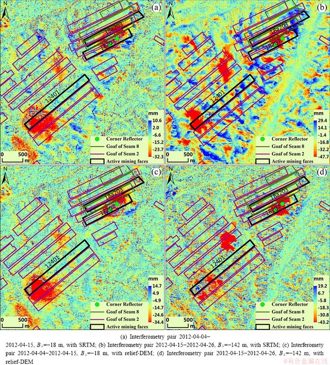
Fig. 5 Deformation map resulted from DInSAR technique with different external DEMs
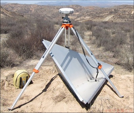
Fig. 6 Trihedral corner reflector installed in research area
Figure 8 shows the results of multi-baseline DInSAR and PSI technique. Actually, this area was influenced by two active mining faces (18207 and 18a203), and the upper coal seams were already mined out. The subsided area was identified and marked by light blue polygon based on DInSAR results (Fig. 8(a)). The two green lines indicate the location of main section of subsidence. The main section in strike direction slightly deviates from the centre of mining face 18207 due to the existence of another active mining face 18a203. In the bottom and left of Fig. 8(b), we can observe a small subsided area, marked by red ellipses outside the light blue polygon. This illustrates that PSI could identify the bounds of subsided area more precisely since the errors are due to atmospheric delay, and external DEM was solved during IPTA regression. However, we should also note that this extra small subsidence area was not located near the main section of subsidence, thus making no influence on the subsidence angle which was derived based on DInSAR results [14].
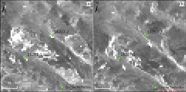
Fig. 7 Geocoded SAR intensity images with 5��5 multilook, based on relief-DEM (a) and SRTM (b)
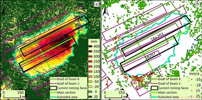
Fig. 8 Subsidence map over mining face 18207 and 18a203, from time-series analysis DInSAR for time span 2012-04-04 to 2013-01-26 (a), and corresponding PSI results from IPTA analysis (b)
Table 3 Quantitative evaluation of geocoding performance
5 Conclusions
1) SRTM could not fully compensate the complicated terrain of the mountainous area.
2) Then corner reflectors installed during the acquisition of SAR dataset were used to estimate the accuracy of geocoding. The terrain corrected geocoding results based on relief-DEM were much better than using SRTM, with the RMSE being 6.35 m in X direction and 11.65 m in Y direction (both in UTM projection), around one pixel of the multilooked intensity image to be geocoded.
3) For PSI technique, the results of time-series analysis of multi-baseline differential interferograms were integrated to restrict only PSCs near the boundary of subsidence area for later IPTA processing. The result demonstrates that PSI could further refine the boundary of subsidence, which could then be used to derive some angular parameters to help people to learn the law of subsidence caused by repeated excavation in this area. This could also provide reference for mine company when designing coal safety pillar to prevent structure from damages prior to mining from a safety point-of-view.
References
[1] HANSSEN R F. Subsidence monitoring using contiguous and PSInSAR: Quality assessment based on precision and reliability [C]//STATHIS C S, STELLA P. Proceedings of the 11th FIG Symposium on Deformation Measurements. Santorini, Greece, 2003.
[2] MEISINA C, ZUCCA F, FOSSATI D, CERIANI M, ALLIEVI J. Ground deformation monitoring by using the permanent scatterers technique: The example of the Oltrepo Pavese (Lombardia, Italy) [J]. Engineering Geology, 2006, 88(3-4): 240-259.
[3] YERRO A, COROMINAS J, MONELLS D,  J J. Analysis of the evolution of ground movements in a low densely urban area by means of DInSAR technique [J]. Engineering Geology, 2014(170): 52-65.
[4] TUNG H, HU J C. Assessments of serious anthropogenic land subsidence in Yunlin county of central Taiwan from 1996 to 1999 by persistent scatterers InSAR [J]. Tectonophysics, 2012(578): 126-135.
[5] ZHANG Yong-hong, ZHANG Ji-xian, GONG Wen-yu, LU Zhong. Monitoring urban subsidence based on SAR interferometric point target analysis [J]. Acta Geodaeticaet Cartographica Sinica, 2009, 38(6): 482-487, 493. (in Chinese)
[6] HE Xiu-feng, ZHONG Hai-bei, HE Min. Ground subsidence detection of nantong city based on PS-InSAR and GIS spatial analysis [J]. Journal of Tongji University: Natural Science, 2011, 39(1): 129-134. (in Chinese)
[7] ZHU Jian-jun, XING Xue-min, HU Jun, LI Zhi-wei. Monitoring of ground surface deformation in mining area with InSAR technique [J]. The Chinese Journal of Nonferrous Metals, 2011, 21(10): 2564-2576. (in Chinese)
[8] WALTER D, HOFFMANN J, KAMPES B, SROKA A. Radar interferometric analysis of mining induced surface subsidence using permanent scatterer [C]//LACOSTE H, OUWEHAND L. Proceedings of the 2004 Envisat & ERS Symposium (ESA SP-572). Salzburg: ESA Publications Division.
[9] COLESANTI C, MOUELIC S, BENNANI M, AUCOULES D, CARNEC C, FERRETTI A. Detection of mining related ground instabilities using the Permanent Scatterers technique��A case study in the east of France [J]. International Journal of Remote Sensing, 2005, 26(1): 201-207.
[10] HERRERA G, TOMS R, LOPEZ-SANCHEZ J M, DELGADO J, MALLORQUI J J, DUQUE S, MULAS J. Advanced DInSAR analysis on mining areas: La Union case study (Murcia, SE Spain) [J]. Engineering Geology, 2007, 90(3-4): 148-159.
[11]  U, WALTER D, SPRECKELS V, WERNER C L. Nonuniform ground motion monitoring with Terrasar-x persistent scatterer interferometry [J]. IEEE Transactions on Geoscience and Remote Sensing, 2010, 48(2): 895-904.
[12] XING Xue-min, GONG Yong-kui, ZHU Jian-jun. Subsidence monitoring in mining area based on PSInSAR [J]. Journal of Computational Information Systems, 2010, 6(9): 2909-2916.
[13] XING Xue-min, ZHU Jian-jun, WANG Yong-zhe, YANG Ya-fu. Time series ground subsidence inversion in mining area based on CRInSAR and PSInSAR integration [J]. Journal of Central South University, 2013, 20: 2498-2509.
[14] LIU Zhen-guo, BIAN Zheng-fu,  Fu-xiang, DONG Bao-quan. Subsidence monitoring caused by repeated excavation with time-series DInSAR [J]. Journal of Mining & Safety Engineering, 2013, 20(3): 390-395. (in Chinese)
[15] ZYl J J. The shuttle radar topography mission (SRTM): A breakthrough in remote sensing of topography [J]. Acta Astronautica, 2001, 48(5-12): 559-565.
PS-DInSAR������ɽ���ظ��ɶ��ر����ݼ���е�Ӧ��
�����1��������1�����ٸ�1��������1,2��Andrew SOWTER3
1. �й���ҵ��ѧ ��������ѧԺ������ 221116��
2. Institute of Geodesy and Photogrammetry, TU Braunschweig, 3, Braunschweig D-38106, Germany;
3. Nottingham Geospatial Institute, University of Nottingham Innovation Park, Triumph Road, Nottingham NG7 2TU, UK
ժ Ҫ�����ڸ߷ֱ���TerraSAR-X ���ݣ�����DInSAR��PSI�������ɽ���ظ��ɶ�����ĵر����ݡ���DInSAR���ݴ��������У��ֱ�����SRTM�����ڿ���������ߺ������ͼ���ɵ�relief-DEM���ⲿDEM��Ӱ����з������ۡ���������������о����ĵ��θ��ӣ�SRTM����ֲ���������λ����������ڿ�����Χ�ڲ���ĽǷ������Ի��ڲ�ͬ�ⲿDEM�ĵ���������м��飬�����ʾ������relief-DEM�ĵ������뾫�����Խ��ţ�����X��Y����ĵ������������ֱ�Ϊ6.35 m��11.65 m������PSI������Ϊ�˽����α��ݶȹ������λ�����Ӱ�죬����ʱ��DInSAR�Ĵ����������ʶ�������PS�������ģ��ʹ��ֻ��λ�ڳ��ݱ�Ե���ȶ������PS������PSI�������������������PSI�������Խ�һ���Ż�ʱ��DInSAR��ȡ�ĵر��α�߽���Ϣ��
�ؼ��ʣ�DInSAR���������룻PSI���ظ��ɶ����Ƿ����������ݼ��
(Edited by Xiang-qun LI)
Foundation item: Project (51174191) supported by the National Natural Science Foundation of China; Project (2013CB227904) supported by the National Basic Research Program of China; Project (2012QNB09) supported by Fundamental Research Funds for the Central Universities, China
Corresponding author: Zheng-fu BIAN; Tel: +86-516-83590159; Email zfbian@cumt.edu.cn
DOI: 10.1016/S1003-6326(14)63471-3
Abstract: The high resolution TerraSAR-X dataset was employed with DInSAR and persistent scatterer interferometry (PSI) technique for subsidence monitoring in a mountainous area. For DInSAR technique, the generally used SRTM and relief-DEM, which was derived from aerial topographic map, were used to evaluate the influence of external DEM. The results show that SRTM could not fully compensate the complex topography of the research area. The corner reflectors installed during the acquisition of SAR dataset were used to estimate the accuracy of geocoding. The terrain corrected geocoding results based on relief-DEM were much better than using SRTM, with the root mean square error (RMSE) being 6.35 m in X direction and 11.65 m in Y direction (both in UTM projection), around one pixel of the multilooked intensity image to be geocoded. For PSI technique, the results from time-series analysis of multi-baseline differential interferograms were integrated to restrict only persistent scatterer candidates near the boundary of subsiding area for regression analysis. The results demonstrate that PSI can refine the boundary of subsidence, which could then be used to derive some angular parameters to help people to learn the law of subsidence caused by repeated excavation in this area.