Trans. Nonferrous Met. Soc. China 24(2014) 1242-1247
A model for extracting large deformation mining subsidence using D-InSAR technique and probability integral method
Hong-dong FAN1,2, Wei GU1, Yong QIN2, Ji-qun XUE3, Bing-qian CHEN 1
1. Jiangsu Key Laboratory of Resources and Environmental Information Engineering, China University of Mining and Technology, Xuzhou 221116, China;
2. School of Resources and Geosciences, China University of Mining and Technology, Xuzhou 221116, China;
3. Zhejiang Geological Prospecting Institute, China Chemical Geology and Mine Bureau, Hangzhou 310002, China
Received 10 July 2013; accepted 24 March 2014
Abstract:
Due to the difficulties in obtaining large deformation mining subsidence using differential Interferometric Synthetic Aperture Radar (D-InSAR) alone, a new algorithm was proposed to extract large deformation mining subsidence using D-InSAR technique and probability integral method. The details of the algorithm are as follows: the control points set, containing correct phase unwrapping points on the subsidence basin edge generated by D-InSAR and several observation points (near the maximum subsidence and inflection points), was established at first; genetic algorithm (GA) was then used to optimize the parameters of probability integral method; at last, the surface subsidence was deduced according to the optimum parameters. The results of the experiment in Huaibei mining area, China, show that the presented method can generate the correct mining subsidence basin with a few surface observations, and the relative error of maximum subsidence point is about 8.3%, which is much better than that of conventional D-InSAR (relative error is 68.0%).
Key words:
D-InSAR; genetic algorithm; probability integral method; mining subsidence;
1 Introduction
As the dominant part of the energy production and consumption in China, coal occupies about 70% of primary consumption. Due to the high-intensity and wide-spread mining, most mining areas are confronted with the serious problem of ground subsidence. Although the classical monitoring methods, such as geodesy, precise leveling, close range photogrammetry, GPS and laser 3D scanning, have high accuracies, there are also many disadvantages such as heavy workload, high cost, difficult to keep the monitoring points in a long time, and difficult to obtain the three-dimensional deformation information of space and a long temporal domain [1,2]. Differential interferometric synthetic aperture radar (D-InSAR) technique, as the research topic in the earth observation field, can solve these problems to some extent [3]. Moreover, D-InSAR has been widely applied in the mining subsidence monitoring [4].
As we known, the mining subsidence is different from that in the cities. Many researches presented that some problems existed in monitoring mining subsidence by D-InSAR. These problems can be summed as follows: 1) The mining subsidence area usually has characteristics of abundant vegetation, fast subsidence velocity, and serious geological hazards [5], which easily induces the loss of coherence between two SAR images, and more, causes phase unwrapping error or obtains the wrong deformation [6]; 2) Calculating errors are usually contained in the subsidence values obtained by D-InSAR, thus, the monitoring values could not accurately match the real mining subsidence [7]; 3) The subsidence models of multi-baseline InSAR technique [8], such as PS-InSAR, SBAS, are commonly designed for small deformation monitoring, so it is difficult to obtain the large deformation of the mining subsidence [9,10].
In order to resolve these problems, this work presents a new model for extracting large deformation mining subsidence using D-InSAR technique and probability integral method. The simulating computation and real data test are performed to evaluate the performance of the proposed model.
2 Parameters of probability integral method
2.1 Probability integral method
Probability integral method is widely used in predicting mining subsidence at present. The method regards the rock mass studied in mining subsidence as a non-continuum model, which is similar to granulosis medium, so the movement laws of rock mass and surface caused by the two models are nearly the same in macroscopic view [11]. According to the principle of probability integral method, the subsidence of any surface point (x, y) caused by mining can be expressed as [12]
 (1)
(1)
where q is the subsidence coefficient; r is the main influence radius, r=H0/tan ��; H0 is the average mining depth; �� is the mining influence angle; tan �� is the tangent of main influence angle; (xi, yi) is the plane coordinate of mining unit i; (x, y) is the coordinate of any surface point.
Probability integral method can predict the mining subsidence correctly, and the main predicting parameters are usually deduced by many observations of mining subsidence. However, the damage or loss of the observation points often takes place, which will result in cost increasing and cannot ensure the predicting accuracy. While, D-InSAR technique can present many points�� subsidence data instead of actual observations, and increase the points�� quantity on the basin edge to deduce the parameters. So, when the probability integral method is used in the prediction, the problem of the rapid convergence in the edge of subsidence basin can be solved to some extent [13].
2.2 Parameters of probability integral method deduced by D-InSAR and GA
Genetic algorithm (GA) [14] was proposed by J. HOLLAND in 1975, which simulated the natural selection and genetic mechanism of organisms in nature. The basic idea of GA is as follows: a group of chromosome population is generated at first; according to survival of the fittest principle, some chromosome is selected to generate new chromosome population by copying, intercross and aberrance; finally, the chromosome population which most adapts the environment is sought by evolution. GA can provide the most optimized solution for the problem.
Thanks to the advantages of GA in parameter deducing, it had been widely applied to parameters analysis in rock and soil mechanics [15,16]. Several experimental results showed that parameters of probability integral method could be deduced precisely by GA. To resolve the problems of D-InSAR used in mining subsidence, a new algorithm that combines D-InSAR and probability integral method to obtain large deformation subsidence is proposed. The processing steps involved in the proposed method are shown in Fig. 1.
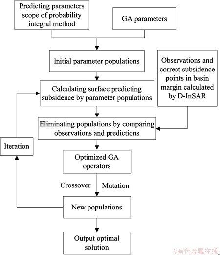
Fig. 1 Flowchart of deducing probability integral method parameters by D-InSAR and GA
3 Experimental analysis
3.1 Simulation analysis
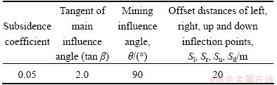
In order to test the ability of subsidence monitoring by D-InSAR, according to the parameters of the simulated working face and probability integral method in Tables 1 and 2, land subsidence basin could be deduced as shown in Fig. 2(a), where the white rectangular frame was the work face. Then, the subsidence value is converted into phase shown in Fig. 2(b) according to the parameters of the ERS or ENVISAT data (i.e., the wavelength is 56 mm, resolution is about 20 m). After that, the phase is wrapped (Fig. 2(c)). Finally, the wrapped phase is unwrapped by minimum cost network flow algorithm [17,18], as shown in Fig. 2(d).
From Figs. 2(b) and (d), it can be seen that, in this mining condition, the true subsidence can be obtained correctly by D-InSAR when the subsidence coefficient is 0.05. When the subsidence coefficient becomes 0.1, and the other parameters are the same, the simulated phase and unwrapped phase are shown in Fig. 3. From Fig. 3, it can be seen that, in this mining condition, it is difficult for D-InSAR to obtain the true subsidence.
Table 1 Parameters of simulated working face
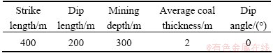
Table 2 Parameters of probability integral method
The unwrapped phase shows that the subsidence of basin edge can be obtained correctly, so these correct unwrapped phase points can be combined with a few observations to deduce the parameters of probability integral method by GA, and then the whole subsidence basin can be calculated by the optimized parameters. This method can not only reduce the number of observation points and monitoring cost, but also solve the difficulty in obtaining the large deformation mining subsidence by D-InSAR.
3.2 Real data test
3.2.1 Work face and SAR data
The work face in this example is II3720 located in Huaibei City, China. The coal seam thickness is 2.7 m, the dip angle is about 5��-15��, and the mining depth is about 300 m. This work face was exploited from 2008-02-12 to 2009-08-22, and the longwall natural collapse method was used. The surface movement observation points were established above II3720 work face, and the movements of these points were measured by GPS, total station measuring system, and leveling. The plane distributions of monitoring points (red crosses) above II3720 work face are shown in Fig. 4.
Two ALOS/PALSAR images with high resolution captured in 2008-04-09 and 2009-01-10, and SRTM3 DEM were used. In this example, standard ��two-pass�� D-InSAR method was used to obtain the surface subsidence. In 2008-04-09, the advance distance of work face was about 30 m, and according to the mining subsidence theory analysis, there was no surface subsidence. To 2009-01-10, the advance distance of work face was about 240 m. Although the subsidence basin was not stable, the model of probability integral method could also obtain the correct mining subsidence.
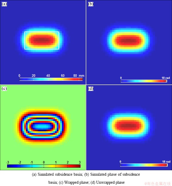
Fig. 2 Simulated phase images (subsidence coefficient is 0.05)

Fig. 3 Simulated phase images (subsidence coefficient is 0.1)
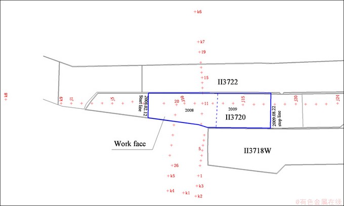
Fig. 4 Plane distributions of monitoring points above II3720 work face
3.2.2 Data process and analysis
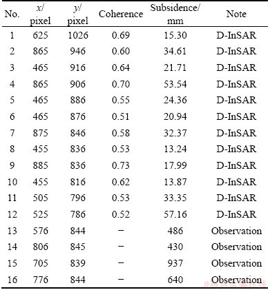
The maximum subsidence calculated by D-InSAR technique is only about 300 mm in this example, but the observation value is about 937 mm. To enhance the performance of InSAR technique, according to the method proposed in this work, the points whose coherence is over 0.5 in the basin edge are selected, and combined with 4 control points (Table 3, near the maximum subsidence and inflection points) to deduce the parameters of probability integral method by GA. Finally, the parameters calculated by this method are as follows: q=0.464, tan ��=2.392, ��=83.964��, Sl=-32.677 m, Sr=24.424 m, Su=15.750 m, Sd=0.504 m.
Table 3 Point information used in monitoring subsidence basin in mining process
The subsidence basin (Fig. 5) is predicted by the parameters. It can be seen that the basin lags behind the distance of work face, and the main subsidence section in strike direction deviates to downhill direction, which accords with the law of mining subsidence. Comparing with the observations of surface monitoring control points (Fig. 6), the average error is about 31 mm, and the absolute error of the maximum subsidence point is about 83 mm, and the relative error is about 8.3%, which is much better than the results of D-InSAR (relative error is 68.0%). Therefore, the method proposed in this work can be used to monitor the mining subsidence effectively.
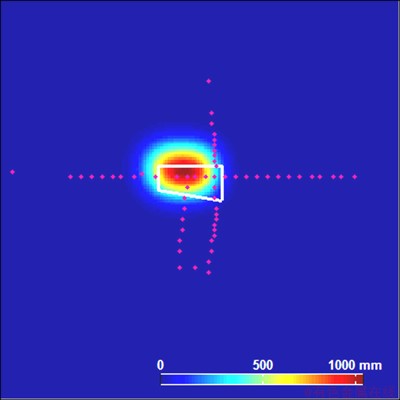
Fig. 5 Predicted mining subsidence basin
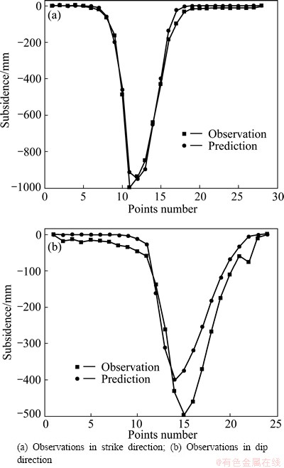
Fig. 6 Comparison of measured values with predicted values
4 Conclusions
1) A new algorithm was proposed to extract large deformation mining subsidence using D-InSAR technique and probability integral method. The real data test indicated that it is feasible to deduce the mining subsidence basin, and the relative error of the maximum subsidence point in the example is about 8.3%, which is much better than the results of D-InSAR (relative error is 68.0%).
2) The surface observations number can be decreased when D-InSAR technique is used. Meanwhile, the number of edge points involved in the prediction of subsidence basin is increased. Therefore, the problem of the rapid convergence of probability integral method in subsidence basin edge can be solved.
3) In this example, the workface was mining when the image was captured, and the land surface above the workface was not stable at that time. So, how to generate the final land subsidence by this method will be studied in the future.
References
[1] FAN Hong-dong, DENG Ka-zhong, JU Cheng-yu, ZHU Chuan-guang, XUE Ji-qun. Land subsidence monitoring by D-InSAR technique [J]. Mining Science and Technology, 2011, 21: 869-872.
[2] SHAN Zheng-ying, HAN Hou-zeng, JIANG Kun. Optimization model of GNSS/pseudolites structure design for open-pit mine positioning [J]. Transactions of Nonferrous Metals Society of China, 2013, 23: 2201-2208.
[3] OSMANOGLU B, DIXON T H, WDOWINSKI S. Mexico City subsidence observed with persistent scatterer InSAR [J]. International Journal of Applied Earth Observation and Geoinformation, 2011, 13(2): 1-12.
[4] NG A H, GE L L, YAN Y Q. Mapping accumulated mine subsidence using small stack of SAR differential interferograms in the Southern coalfield of new south wales, australia [J]. Engineering Geology, 2010, 115: 1-15.
[5] HERRARA G, TOMAS R, VICENTE F. Mapping ground movements in open pit mining areas using differential SAR interferometry [J]. International Journal of Rock Mechanics & Mining Sciences, 2011, 47(7): 1114-1125.
[6] ZHU Jian-jun, XING Xue-min, HU Jun, LI Zhi-wei. Monitoring of ground surface deformation in mining area with InSAR technique [J]. The Chinese Journal of Nonferrous Metals, 2011, 21(10): 15-18. (in Chinese)
[7] FAN Hong-dong, DENG Ka-zhong, XUE Ji-qun, ZHU Chuan-guang. An experimental research on using time series SAR images to monitor mining subsidence [J]. Safety in Coal Mines, 2011, 42(2): 15-19. (in Chinese)
[8] LAUKNES T R., ZEBKER H A, LARSEN Y. InSAR deformation time series using an L1-Norm small-baseline approach [J]. IEEE Transactions on Geoscience and Remote Sensing, 2010, 7(1): 536-547.
[9] GUEGUEN Y, DEFFONTAINES B, FRUNEAU B. Monitoring residual mining subsidence of Nord/Pas-de-Calais coal basin from differential and persistent scatterer interferometry [J]. Journal of Applied Geophysics, 2009, 69: 24-34.
[10] HUANG Qi-huan, HE Xiu-feng. Small baseline DInSAR approach with constraints and its applications [J]. Journal of China University of Mining & Technology, 2009, 38(3): 450-454. (in Chinese)
[11] LI Pei-xian, TAN Zhi-xiang, DENG Ka-zhong. Calculation of maximum ground movement and deformation caused by mining [J]. Transactions of Nonferrous Metals Society of China, 2011, 21(s3): s562-s569.
[12] HE Guo-qing,YANG Lun, LING Geng-di, JIA Feng-cai, HONG Du. Mining subsidence [M]. Xuzhou: China University of Mining and Technology Press, 1991. (in Chinese)
[13] XUE Ji-qun. Research of monitoring mine subsidence by D-InSAR technique [D]. Xuzhou: China University of Mining and Technology, 2012. (in Chinese)
[14] ZHOU Ming, SUN Shu-dong. Principle and application of genetic algorithm [M]. Beijing: National Defense Industry Press, 1999. (in Chinese)
[15] ZHU Sheng, WANG Yong-ming, HU Xiang-qun. Application of immune genetic algorithm to back analysis for parameters in model of rockfill dam coarse grain material [J]. Rock and Soil Mechanics, 2010, 31(3): 961-966. (in Chinese)
[16] ZHA Jian-feng, FENG Wen-kai, ZHU Xiao-jun. Research on parameters inversion in probability integral method by genetic algorithm [J]. Journal of Mining & Safety Engineering, 2011, 28(4): 655-659. (in Chinese)
[17] BOYKOY Y, KOLMOGOROY V. An experimental comparison of min-cut/max-flow algorithms for energy minimization in vision [J]. IEEE Transactions on Pattern Analysis and Machine Intelligence, 2004, 26(9): 1124-1137.
[18] JOSE M B, GONCALO V. Phase unwrapping via graph cuts [J]. IEEE Transactions on Image Processing, 2007, 16(3): 698-709.
����D-InSAR���ʻ��ַ��Ŀ�������εر�������ȡ����
���鶬1,2���� ΰ1���� ��2��Ѧ��Ⱥ3���±�Ǭ1
1. �й���ҵ��ѧ ����ʡ��Դ������Ϣ�����ص�ʵ���ң����� 221116��
2. �й���ҵ��ѧ ��Դ������ѧѧԺ������ 221116��
3. �л����ʿ�ɽ�ܾ� �㽭���ʿ���Ժ������ 310002
ժ Ҫ����Բ�ֺϳɿ��״���������D-InSAR����������ȷ��ȡ�����ر�������������⣬���D-InSAR�����ʻ��ַ����ϻ�ȡ�������������·������������Ϊ����D-InSAR�����õ��³���أ�ѡȡ��ر�Ե���ϵ���ϴ���³�����С�ĵ㣬�ټ�������³���յ㸽��������ʵ�����Ϊ������Ƶ㣻Ȼ������Ŵ��㷨�Ը��ʻ��ַ��������Ͻ����Ż�������ɽ�������Ų�������ر��³���ء�ʵ���������÷����ܹ��ڼ��ٵ����������������»�ȡ��Ϊȷ�ĵر�������������³���������Ϊ8.3%������D-InSAR�ļ����(������Լ68.0%)��
�ؼ��ʣ�D-InSAR���Ŵ��㷨(GA)�����ʻ��ַ������ɳ���
(Edited by Sai-qian YUAN)
Foundation item: Project (BK20130174) supported by the Basic Research Project of Jiangsu Province (Natural Science Foundation); Project (1101109C) supported by Jiangsu Planned Projects for Postdoctoral Research Funds, China; Project (201325) supported by the Key Laboratory of Geo-informatics of State Bureau of Surveying and Mapping, China; Project (SZBF2011-6-B35) supported by the Priority Academic Program Development of Jiangsu Higher Education Institutions, China
Corresponding author: Wei GU; Tel:+86-13775898958; E-mail: guweicumt@163.com
DOI: 10.1016/S1003-6326(14)63185-X
Abstract: Due to the difficulties in obtaining large deformation mining subsidence using differential Interferometric Synthetic Aperture Radar (D-InSAR) alone, a new algorithm was proposed to extract large deformation mining subsidence using D-InSAR technique and probability integral method. The details of the algorithm are as follows: the control points set, containing correct phase unwrapping points on the subsidence basin edge generated by D-InSAR and several observation points (near the maximum subsidence and inflection points), was established at first; genetic algorithm (GA) was then used to optimize the parameters of probability integral method; at last, the surface subsidence was deduced according to the optimum parameters. The results of the experiment in Huaibei mining area, China, show that the presented method can generate the correct mining subsidence basin with a few surface observations, and the relative error of maximum subsidence point is about 8.3%, which is much better than that of conventional D-InSAR (relative error is 68.0%).