J. Cent. South Univ. (2021) 28: 1775-1785
DOI: https://doi.org/10.1007/s11771-021-4661-6

Estimating model for urban carrying capacity on bike-sharing
YU Jia-jie(��ѽ�)1, JI Yan-jie(�����)1, 2, YI Chen-yu(�׳���)3, LIU Yang(����) 4
1. School of Transportation, Southeast University, Nanjing 211189, China;
2. Jiangsu Key Laboratory of Urban ITS, Jiangsu Province Collaborative Innovation Center of
Modern Urban Traffic Technologies, Nanjing 211189, China;
3. Shenzhen Urban Transport Planning Center Co. Ltd., Shenzhen 518057, China;
4. Faculty of Transportation Engineering, Kunming University of Science and Technology,Kunming 650051, China
 Central South University Press and Springer-Verlag GmbH Germany, part of Springer Nature 2021
Abstract:
As the demand for bike-sharing has been increasing, the oversupply problem of bike-sharing has occurred, which leads to the waste of resources and disturbance of the urban environment. In order to regulate the supply volume of bike-sharing reasonably, an estimating model was proposed to quantify the urban carrying capacity (UCC) for bike-sharing through the demand data. In this way, the maximum supply volume of bike-sharing that a city can accommodate can be obtained. The UCC on bike-sharing is reflected in the road network carrying capacity (RNCC) and parking facilities�� carrying capacity (PFCC). The space-time consumption method and density-based spatial clustering of application with noise (DBSCAN) algorithm were used to explore the RNCC and PFCC for bike-sharing. Combined with the users�� demand, the urban load ratio on bike-sharing can be evaluated to judge whether the UCC can meet users�� demand, so that the supply volume of bike-sharing and distribution of the related facilities can be adjusted accordingly. The application of the model was carried out by estimating the UCC and load ratio of each traffic analysis zone in Nanjing, China. Compared with the field survey data, the effect of the proposed algorithm was verified.
Key words:
Cite this article as:
YU Jia-jie, JI Yan-jie, YI Chen-yu, LIU Yang. Estimating model for urban carrying capacity on bike-sharing [J]. Journal of Central South University, 2021, 28(6): 1775-1785.
DOI:https://dx.doi.org/https://doi.org/10.1007/s11771-021-4661-61 Introduction
Due to the advantages of environmentally friendly and flexible, bicycle traffic has been widely recognized and advocated [1]. In many Chinese cities, bikes are unable to be carried into the metro or buses, which cause inconvenience to ��bike+metro�� and ��bike+bus��travelers [2]. Therefore,bike-sharing became popular as soon as it appeared.
The bike-sharing, also known as dockless public bikes [3], has the characteristics of taking and parking at any place, and it works for solving the last kilometer problem of the transit trip for travelers [4, 5]. However, with the increasing demand for shared bikes, many bike-sharing enterprises oversupplied their bikes to seize the market [6]. The low bike repositioning efficiency results in a large amount of resources waste [7, 8], and the parking pressure of bikes increases sharply even exceeding the urban carrying capacity [9-11].
In order to regulate the supply volume of bike-sharing, it is necessary to consider that how many shared bikes can a city accommodate under the premise of sustainable development, in other words, the urban carrying capacity (UCC) on bike-sharing [12, 13]. The supply volume of bike-sharing should meet the users�� demand as much as possible without exceeding the UCC.
In the field of urban planning, the concept of UCC is defined as the level of human activities, population growth, land use and physical development, which can be sustained by the city without causing serious degradation and irreversible damage to the environment [12, 14, 15].
As a part of UCC, the urban traffic carrying capacity system consists of two aspects, environmental carrying capacity and traffic facilities�� carrying capacity [16, 17]. Existing researches on urban traffic carrying capacity for motor vehicles mainly concentrated on road network carrying capacity (RNCC) and environmental carrying capacity.
RNCC refers to the maximum number of vehicles that can be transferred in the road network within a certain spatial and temporal range. There are lots of methods to quantify the RNCC. IIDA [18] explored a calculation method for RNCC based on the simple growth distribution method, which was the earliest one to apply the equilibrium distribution method to the research of road network capacity. By establishing a balanced road network capacity model, ASAKURA et al [19] carried out a simulation allocation calculation of Tokyo road carrying capacity. AKAMATSU et al [20] proposed a single-layer model of road network carrying capacity and applied saturated flow and network graph method to exploring the user equilibrium problem under elastic demand. The time-space consumption model is a common method to calculate the time-space resources and capacity of road networks. This model is developed according to the relation between the total time-space resources of the road network and the time-space resources consumed by individuals [16, 21]. In addition, the dynamic traffic assignment model and field experiment can also be used to analyze the road network capacity [22, 23].
As for environmental carrying capacity, it is the largest effect of human activities that the environmental system can accommodate [24, 25]. Many scholars tried to estimate the environmental carrying capacity by the resources and demand differences and comprehensive evaluation.WANG et al [26] applied a ��pressure-support��, ��destructiveness-resilience��, and ��degradation-promotion�� (��PS-DR-DP��) hexagon interaction theoretical model to evaluate environmental carrying capacity and carried out a further empirical study on Beijing, China over the period between 2010 and 2015.
In summary, through the unremitting efforts of many scholars, the research foundation on urban traffic carrying capacity has been formed, but the existing researches on RNCC are mainly from the perspective of motor vehicle traffic, while the analysis on non-motor vehicle traffic like bike-sharing systems is lacked. Except for the road network, the parking facility is also an important resources that determine the urban traffic carrying capacity. However, the research on parking facilities�� carrying capacity (PFCC) is limited, and the PFCC for bicycles is not as visualized as that for motor vehicles. Thus, the quantification method of PFCC on bike-sharing also needs to be explored.
To solve the above problems, this paper proposed a complete method to quantify the UCC on bike-sharing which mainly consists of the RNCC and PFCC. The time-space consumption method is used to explore the RNCC of bike-sharing, and the PFCC is estimated by an improved density-based spatial clustering of application with noise (DBSCAN) algorithm. Based on the bike-sharing users�� travel information recorded by the smartphone APP, the load ratio on bike-sharing of the city is also obtained. Then, taking Nanjing city in China as an example, the UCC and load ratio on bike-sharing are evaluated to validate the application of the proposed model.
2 Method
As a part of the urban transportation system, bike-sharing is a type of green transit mode. Unlike motor vehicles, it will not cause a series of environmental pollution problems such as exhaust emission, noise pollution, and light pollution [27]. Therefore, this study mainly focuses on the carrying capacity of urban traffic facilities of bike-sharing, including the road network and parking facilities.
2.1 Road network carrying capacity
The RNCC on the bike-sharing refers to the maximum number of shared bikes that can be transferred in the urban road network within a certain spatial and temporal range. In this paper, the RNCC on the bike-sharing is measured based on the time-space consumption method [16, 17].
The total spatial and temporal resources of the urban non-motor vehicle road network are as follows:
 (1)
(1)
where Cr is the total spatial and temporal resources of the bike lane network, km��h; L and T are the total length and service time of the bike lane network, respectively.
The space-time consumption of a single non-motor vehicle is:
 (2)
(2)
where Cv is the time-space consumption of a single non-motor vehicle, km/bikeu; hv is the average headspace of non-motor vehicles, km/bikeu; tave is the average travel time of a non-motor vehicle, h; lave is the average travel distance of a non-motor vehicle, km; c is the average capacity of a single bike lane, bikeu/h.
The carrying capacity of the bike lane network is as follows:
 (3)
(3)
where CRi,tis the carrying capacity of the bike lane network, bikeu/h; Cr,i is the total space-time resource of the bike lane network in the i-th traffic analysis zone, km��h; Li is the total length of bike lanes in the i-th traffic analysis zone, km.
The effective spatial and temporal resources of bike lanes are affected by the green split of signalized intersections, roadside interference, mixed traffic flow interference, road layout and isolation mode between motor vehicle lane and bike lane.
 (4)
(4)
where k represents different road classes; li,k is the length of bike lanes in the ith traffic zone, km; ��k,1 is the reduction coefficient of bike lane caused by the intersection; ��k,2 is the comprehensive reduction coefficient; ��k,3 is the effective coefficient of bike lanes.
Then, the carrying capacity of the bike lane network becomes:
 (5)
(5)
There are different types of non-motors transferring on the bike lanes at the same time, including bike and e-bike. The differences in the speed and space consuming between the two modes are non-negligible, so the concept of the conversion coefficient of the e-bike and the bike needs to be introduced.
The conversion coefficient for motor vehicles (like trucks and buses) is defined as when the road and traffic conditions are constant, a truck or a bus can be replaced by a certain number of passenger car units (pcu) to get the same road resources consumption. The replacement number here is called equivalent car unit conversion coefficient [28, 29]. Similarly, the conversion coefficient of the e-bike to the bike can be defined as when the road and traffic conditions are constant, an e-bike can be replaced by a certain number of bike units (bikeu) [30, 31].
Thus, the average capacity of a bike lane for the bike is:
 (6)
(6)
where  is the conversion coefficient of the e-bike;
  is the percentage of the e-bike in the non-motor traffic flow.
The weighted average travel distance of the non-motor is:
 (7)
(7)
where lave,e-bike and lave,bike are the average travel distance of the e-bike and bike, km.
After converting the e-bike into the bike, the time and space consumption of every single bike unit is:
 (8)
(8)
Finally, the capacity of the bike lane network is:

 (9)
(9)
In the non-motor traffic flow, the total proportion of the bike is  . Then, the RNCC of the shared bike is:

 (10)
(10)
where �� is the proportion of shared bikes accounting for all types of bikes.
2.2 Parking facilities�� carrying capacity
Due to the oversupply of shared bikes and the unclear parking areas delimitation, a huge number of shared bikes are parked illegally. Illegal parking behavior in this paper means that the parking behavior of the shared bike affects the environment and causes inconvenience to travelers or other modes of traffic. For example, the parking behavior that the bike occupies a bike lane or a motor lane is illegal. However, legal parking areas of bikes in the city are so scattered and unclear that it is impossible to count how many bikes can be parked in a city under the premise of sustainable development. Thus, it is necessary to explore a method to identify legal parking areas and their capacity.
According to the field survey, bikes are parked more neatly and compactly in the legal parking areas than those parked in illegal parking areas, and the amount of bikes in legal parking areas is always larger than that in illegal parking areas [32]. Due to this characteristic on the parking behavior of bike-sharing, the density-based spatial clustering of application with noise (DBSCAN) algorithm can be used to identify the legal parking areas and their capacity for bike-sharing. In order to avoid the excessive accumulation of shared bikes being identified as a reasonable parking behavior within the carrying capacity, we take the highest density, 1.0 bikeu/m2, which is formed by the required minimum parking area of a bike, as the upper bound of parking density [33]. If the density of shared bikes exceeds the threshold, the capacity of parking facilities will be calculated according to the threshold.
The DBSCAN algorithm is widely used in the fields of machine learning and data mining. It is characterized by dividing objects into clusters according to the density. The basic definition of the DBSCAN algorithm is as follows [34, 35].
��-close neighbor: For any point p, the domain within the radius of �� is called ��-close neighbor of point p.
Core point: In point set D, for the object point p, if the number of points contained in its ��-close neighbor is larger than the neighborhood density threshold MinPts, the point p is called the core point.
Directly density-reachable (DDR): In point set D, if point q is the �� nearest neighbor of point p, and point p is the core point, then the point q is the DDR of point p based on MinPts.
Density-reachable (DR): In point set D, if there is a series of points p1, p2, ��, pn that each pi is the DDR of pi+1, then point pn is the DR of other points based on MinPts.
Density-connected (DC): If o is both DR of p and q, then p is DC of q.
Figure 1 shows the concepts of DDR, DR, and DC.
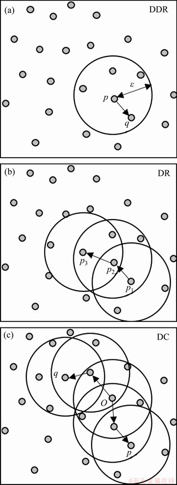
Figure 1 Graphic definition of DDR, DR, and DC
DBSCAN is based on density clustering, which is to find some clusters that are DC to maximize the DR. The steps of the parking areas identification with the density constraint are as follows [36-38].
Step 1: For the sample set D, randomly take one unprocessed object p. If there are more than MinPts points in the ��-close neighbor of object p, the object p is a core point.
Step 2: Collect all the objects in this set D that are DR of object p as a cluster.
Step 3: Through the DC process, generate the final clusters.
Step 4: For unprocessed objects, repeat steps 2 and 3 until all objects have been processed.
Step 5: Check the upper bound of the density of each cluster.
The parking facilities�� capacity on bike-sharing is:
 (i=1, 2, ��, n; j=1, 2, ��,7) (11)
where i is the number of traffic analysis zones; pi is the parking facilities�� capacity of traffic analysis zone i; Pmobile,i is the number of mobikes, which is a type of bike-sharing; ri is mobike��s share of the bike-sharing market.
When it comes to the carrying capacity of bike-sharing parking facilities, it is necessary to pay attention to the parking times of the shared bike that each parking area can hold in a certain period. The concept of the parking area turnover rate needs to be introduced, which is the average parking times for each parking space in a certain period [39-41].
The PFCC of bike-sharing is:
 (12)
(12)
where CPi,tis the PFCC of bike-sharing, bikeu/h; ��j,t is the turnover rate of the bike-sharing parking space in administrative district j during the period t.
2.3 Load ratio of UCC
For bike-sharing traffic facilities, the load ratio of the UCC can reflect the ratio of actual bike-sharing demand and the RNCC/PFCC. The load ratio of the UCC can be used to examine whether the UCC can meet the demand of bike-sharing [42].
The load ratios of the road network and parking facilities on bike-sharing are shown as follows:
 (13)
(13)
 (14)
(14)
where Ni,t and NPi,tare the bike-sharing volume and the parking demand in period t in the i-th traffic analysis zone, respectively.
3 Numerical examples
In this section, numerical example was conducted to validate the proposed methods. The study area contains five districts of Nanjing city, one of the Chinese megacities. There are 193 traffic analysis zones in this study area.
3.1 Data preparation
The data used in this paper include the length data of different levels of roads in each traffic analysis zone and the parking location data of mobike.
Using road network data of Nanjing city, the length data of different levels of road in each traffic zone are calculated by ArcGIS. The mobike travel data come from the mobike company, and the time span of the travel data is from September 18 to 23, 2017. The row data contains the information of trip ID, user ID, bike ID, the starting time and location of each trip, the ending time and location of each trip. After deleting the incomplete and unreasonable trip data (travel distance is larger than 5 km or less than 100 m, and travel duration is less than 30 s or longer than 2 h [43]), there are 2704294 valid samples among six days. The data structure is showed in Table 1.
3.2 Parameters calibration
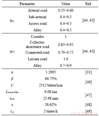
As Nanjing city in this application is one of the Chinese megacities, relevant studies about Nanjing and other similar cities in China are referenced to calibrate the parameters in our model. Specific calculation methods and processes of these parameters can be obtained from the literature mentioned in the following table, and the value of each parameter is summarized in Table 2. Detailed calculation methods of these parameters can be found in these cited papers.
Table 1 Data structure of mobike
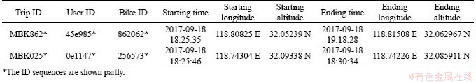
Table 2 Parameters calibration
3.3 Road network carrying capacity
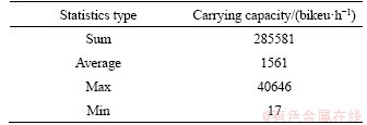
According to the calculation method above, the RNCC of each traffic zone in the research region was calculated. The statistical data are shown in Table 3.
The RNCC (bikeu/h) and its density (bikeu/(h��km2)) of each traffic zone in Nanjing are shown in Figure 2.
The RNCC of each traffic analysis zone varies from 109 to 7266 bikeu/h, with the average carrying capacity of 930 bikeu/h. According to Figure 2, it can be found that the RNCC increases from the city center to the outer suburbs. The spatial distribution characteristics of its density show opposite changing
Table 3 Statistical data of road network carrying capacity
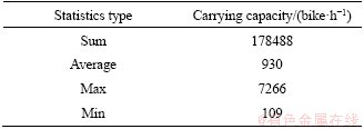
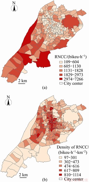
Figure 2 Spatial distribution of RNCC (a) and its density (b)
rules. The closer to the city center, the higher RNCC density on bike-sharing is. However, both the RNCC and RNCC density of Jianye District are generally high though this area is not located in the city center.
3.4 Parking facilities�� carrying capacity
3.4.1 Parking area identification
The parking location data at 01:01:24 am on September 26, 2017, when the data volume is at maximum level, were used. There are 124316 valid samples within study area, and the parking location data include the date, time, bike ID, the longitude and latitude of the bike location. According to the algorithm introduced above, a total of 33593 illegal parking areas were identified in the research region. The algorithm identified 7460 legal parking areas, with an average of 4.52 mobikes parked in each spot. The illegal parking behavior accounts for 49.88% of all. According to the investigation on illegal parking behavior of bike-sharing in Nanjing, China, in September 2017, 470 times of bike-sharing parking behaviors were observed, among which 228 times of bike-sharing parking behaviors were illegal, accounting for 48.51% of the total. The difference between the results of parking identification and field investigation is really small, so the algorithm proposed in this paper is suitable for the bike-sharing parking area identification.
3.4.2 Calculation of PFCC
According to the aforementioned method, the PFCC and its density of each traffic zone are calculated. Due to the limitation of the operating range of Mobike, the PFCCs in 183 traffic zones were obtained, and the statistical data are shown in Table 4. Among 183 traffic zones, the average capacity of parking facilities is 1561 bikeu/h.
Table 4 Statistical data of parking facilities carrying capacity
The PFCC (bikeu/h) and its density (bikeu/(h��km2)) of each traffic zone in Nanjing, China, are shown in Figure 3.
Different from the rule of RNCC, the results showed that the PFCC is generally small in the central area of the city, and the density is also low. The compact land use in the city center and the lack of parking resource lead to the low PFCC density. In contrast, the parking facilities near scenic areas with large land resources have a higher density of PFCC. The PFCC of each traffic analysis zone varies from 17 to 40646 bikeu/h. The highest PFCC density occurs in two parks.
3.5 Load ratio of each traffic zone
It should be noted that the parking demand consists of the parking demand of shared bikes in use and the supply volume of shared bikes in this traffic zone. Once the car is returned, the parking demand will be generated. Then the parking demand is the sum of renting shared bikes and returning shared bikes.
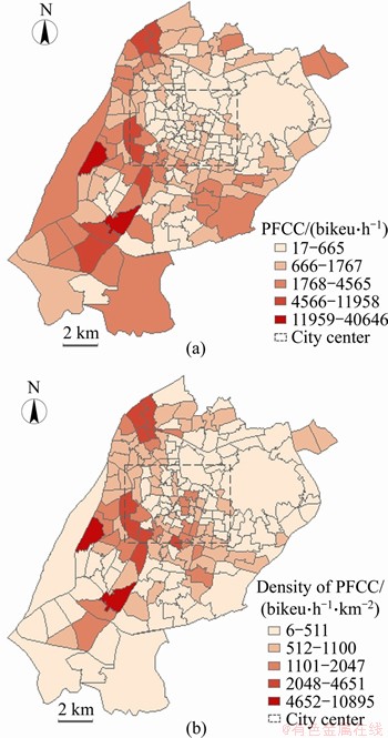
Figure 3 Spatial distribution of PFCC (a) and its density (b)
The peak hour��s (8:00-9:00) renting and returning demand for shared bikes in 2017 was calculated and compared with the carrying capacity. The load ratio of Nanjing city during peak hours can be obtained, as shown in Table 5. It is found that the PFCC can barely meet the demand of sharing bikes during peak hours, but the RNCC is unable to meet the demand of bike-sharing.
The load ratio of the road network and parking facilities of each traffic zone are shown in Figure 4.
Due to the high demand for bike-sharing and unreasonable supply of shared bikes, the load ratios of parking facilities and road network in most traffic analysis zones have exceeded 1.0, which means that the UCC cannot meet the demand for bike-sharing.
Table 5 Load ratio during peak hours
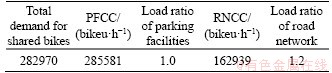
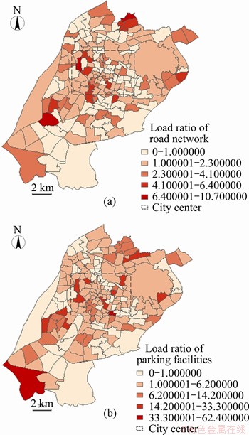
Figure 4 Spatial distribution of load ratio of road network (a) and parking facilities (b)
The spatial distribution of the load ratio is extremely uneven. The load ratio of the road network reached 6-10 in some traffic zones, while in many areas, it has reached 10.0 or even 30.0. In general, the load ratio on bike-sharing is too large, and the spatial distribution is uneven. Therefore, it is necessary to allocate the supply volume of the shared bikes reasonably and extend the UCC of some traffic zones.
To extend the RNCC, the availability of bike lane is necessary, because it can avoid the interference from vehicles and reduce the impact on RNCC. Giving more right of way to bikes in the intersection is another method to enlarge the reduction coefficient of RNCC. To extend the PFCC, parking areas for bikes need to be demarcated reasonably, and the parking guidance for users is necessary. Due to the shortage of land resources, the extension to RNCC and PFCC is limited. The supply volume of bike-sharing should be allocated according to the UCC. The quantitative results of UCC can be set as constrains when optimizing the supply volume of bike-sharing for each traffic analysis zone. More intuitively, the supply volume of bike-sharing in the traffic analysis zones where the load ratio is more than 1.0 should be reduced.
4 Conclusions
Through the renting and returning data of bike-sharing, this paper put forward an estimating model to measure the carrying capacity of the road network and parking facilities for bike-sharing. Combined with the users�� demand, the load ratio of the city on bike-sharing can be evaluated. The model proposed in this paper was applied by estimating the urban carrying capacity of each traffic analysis zone in Nanjing city, China.
The estimating method of the road network carrying capacity for the bike-sharing was obtained based on the time-space consumption method which is commonly used on motor vehicles, and the interaction between the e-bike and bike was considered. As for parking facilities�� carrying capacity, according to the differences between the characteristics of bike-sharing legal parking and illegal parking, the DBSCAN algorithm was used to identify legal parking areas of shared bikes. The upper bound of reasonable parking density was taken into consideration, so as to make the identification algorithm more accurately. Through the case study of each traffic zone in Nanjing city, the effect of the algorithm of the parking facilities capacity calculation in this paper was verified. Compared with the existing studies on public/shared bikes, the main contributions of this paper are as follows:
The space-time consumption method for motor vehicles is evolved into bikes, which provides a quantitative method for urban road network carrying capacity on bikes.
The DBSCAN algorithm is used to identify the parking areas of bikes in the city, and the estimating model for the parking facilities�� carrying capacity on bike-sharing is proposed based on the algorithm.
Bike-sharing is a type of low-carbon and sustainable transit modes, which can effectively solve the problem of travelers�� first and last kilometer of a trip and improve the accessibility of the urban public transportation system. It is important to develop and use this public transport mode reasonably, so that the bike-sharing system can survive healthily and sustainably and serve the city residents better. In further work, the optimization model of the supply volume and repositioning schemes restricted by the urban carrying capacity should be established to regulate the bike-sharing supply volume.
Contributors
YU Jia-jie provided the concept and edited the draft of manuscript. YI Chen-yu conducted the literature review and wrote the first draft of the manuscript. JI Yan-jie and LIU Yang edited the draft of manuscript.
Conflict of interest
YU Jia-jie, JI Yan-jie, YI Chen-yu, and LIU Yang declare that they have no conflict of interest.
References
[1] DILL J. Bicycling for transportation and health: The role of infrastructure [J]. Journal of Public Health Policy, 2009, 30(1): S95-S110. DOI: 10.1057/jphp.2008.56.
[2] JI Yan-jie, FAN Ying-ling, ERMAGUN A, CAO Xue-ning, WANG Wei, DAS K. Public bicycle as a feeder mode to rail transit in China: The role of gender, age, income, trip purpose, and bicycle theft experience [J]. International Journal of Sustainable Transportation, 2017, 11(4): 308-317. DOI: 10.1080/15568318.2016.1253802.
[3] PRITCHARD R. Revealed preference methods for studying bicycle route choice��A systematic review [J]. International Journal of Environmental Research and Public Health, 2018, 15(3): 470. DOI: 10.3390/ijerph15030470.
[4] LIU Zhi-li, JIA Xu-dong, CHENG Wen. Solving the last mile problem: Ensure the success of public bicycle system in Beijing [J]. Procedia - Social and Behavioral Sciences, 2012, 43: 73-78. DOI: 10.1016/j.sbspro.2012.04.079.
[5] ZHANG Yong-ping, MI Zhi-fu. Environmental benefits of bike sharing: A big data-based analysis [J]. Applied Energy, 2018, 220: 296-301. DOI: 10.1016/j.apenergy.2018.03.101.
[6] MA Wan-jing, ZOU Li, AN Kun, GARTNER N H, WANG Meng. A partition-enabled multi-mode band approach to arterial traffic signal optimization [J]. IEEE Transactions on Intelligent Transportation Systems, 2019, 20(1): 313-322. DOI: 10.1109/TITS.2018.2815520.
[7] FORMA I A, RAVIV T, TZUR M. A 3-step math heuristic for the static repositioning problem in bike-sharing systems [J]. Transportation Research Part B: Methodological, 2015, 71: 230-247. DOI: 10.1016/j.trb.2014.10.003.
[8] HAN Zeng-yi, YANG Yong-jian, JIANG Yun-peng, LIU Wen-bin, WANG En. SDVRP-based reposition routing in bike-sharing system [M]//Algorithms and Architectures for Parallel Processing. Cham: Springer International Publishing, 2018: 596-610. DOI: 10.1007/978-3-030-05054-2_45.
[9] CIANCIA V, LATELLA D, MASSINK M, PAKAUSKAS R. Exploring spatio-temporal properties of bike-sharing systems [C]// 2015 IEEE International Conference on Self-Adaptive and Self-Organizing Systems Workshops. Cambridge, MA, USA: IEEE, 2015: 74-79. DOI: 10.1109/SASOW.2015.17.
[10] YIN Jue-lin, QIAN Li-xian, SHEN Jun-jie. From value co-creation to value co-destruction? The case of dockless bike sharing in China [J]. Transportation Research Part D: Transport and Environment, 2019, 71: 169-185. DOI: 10.1016/j.trd.2018.12.004.
[11] SUN Fei-yang, CHEN Peng, JIAO Jun-feng. Promoting public bike-sharing: A lesson from the unsuccessful Pronto system [J]. Transportation Research Part D: Transport and Environment, 2018, 63: 533-547. DOI: 10.1016/j.trd. 2018.06.021.
[12] OH Kyushik, JEONG Yeunwoo, LEE Dongkun, LEE W. An integrated framework for the assessment of urban carrying capacity [J]. J Korea Plan Assoc, 2002, 37(5): 7-26.
[13] WEI Yi-gang, HUANG Cui, LAM P T I, YUAN Zhi-yang. Sustainable urban development: A review on urban carrying capacity assessment [J]. Habitat International, 2015, 46: 64-71. DOI: 10.1016/j.habitatint.2014.10.015.
[14] OH K, JEONG Y, LEE D, LEE W, CHOI J. Determining development density using the urban carrying capacity assessment system [J]. Landscape and Urban Planning, 2005, 73(1): 1-15. DOI: 10.1016/j.landurbplan.2004.06.002.
[15] SU Yi-kun, XUE Hong, LIANG Hua-kang. An evaluation model for urban comprehensive carrying capacity: An empirical case from Harbin City [J]. International Journal of Environmental Research and Public Health, 2019, 16(3): 367. DOI: 10.3390/ijerph16030367.
[16] GAO Shan-shan, YUAN Zhen-zhou. Models and evaluation for urban traffic carrying capacity [J]. Applied Mechanics and Materials, 2013, 409-410: 1258-1261. DOI: 10.4028/www. scientific.net/amm.409-410.1258.
[17] HOU De-shao. Study on urban traffic carrying capacity, in school of transportation [D]. Shanghai: Tongji University, 2008. (in Chinese)
[18] IIDA Y. Studies on methodology for maximum capacity of road network [J]. Proceedings of the Japan Society of Civil Engineers, 1972, 205: 121-129. DOI: 10.2208/ jscej1969.1972.205_121.
[19] ASAKURA Y, KASHIWADANI M. Estimation model of maximum road network capacity with parking constraints and its application [J]. Infrastructure Planning Review, 1993, 11: 129-136. DOI: 10.2208/journalip.11.129.
[20] AKAMATSU T, MIYAWAKI O. Maximum network capacity problem under the transportation equilibrium assignment [J]. Infrastructure Planning Review, 1995, 12: 719-729. DOI: 10.2208/journalip.12.719.
[21] ZHOU Xu-zhao, LIU Can-qi, YANG Pei-kun. Time-space sources of the network of urban road and space-capacity of traffic [J]. Journal of Tongji University, 1996, 24(4): 392-397. (in Chinese)
[22] TORRISI V, IGNACCOLO M, INTURRI G. Analysis of road urban transport network capacity through a dynamic assignment model: Validation of different measurement methods [J]. Transportation Research Procedia, 2017, 27: 1026-1033. DOI: 10.1016/j.trpro.2017.12.135.
[23] GEROLIMINIS N, DAGANZO C F. Existence of urban-scale macroscopic fundamental diagrams: Some experimental findings [J]. Transportation Research Part B: Methodological, 2008, 42(9): 759-770. DOI: 10.1016/j.trb.2008.02.002.
[24] BROWN K, TURNER R K, HAMEED H, BATEMAN I. Environmental carrying capacity and tourism development in the Maldives and Nepal [J]. Environmental Conservation, 1997, 24(4): 316-325. DOI: 10.1017/s0376892997000428.
[25] ZENG Wei-hua, WANG Hua-dong, XUE Ji-yu, YE Wen-hu, GUAN Bo-ren, MEI Feng-qiao. Environmental carrying capacity: A key to coordinating population, resources and environment [J]. Chinese Journal of Population, Rsources and Environment, 1992. 1(1): 26-32. DOI: 10.1080/10042857. 1992.10677332.
[26] WANG Zhong-gen, XIA Jun. Quantitative analysis on bearing capacity of ecological environment [J]. Journal of Changjiang Vocational University, 1999, 16(4): 9-12. DOI: CNKI: SUN:CJZG.0.1999-04-003. (in Chinese)
[27] FAIZ A, GAUTAM S, BURKI E. Air pollution from motor vehicles: Issues and options for Latin American countries [J]. Science of the Total Environment, 1995, 169(1-3): 303-310. DOI: 10.1016/0048-9697(95)04662-K.
[28] VAHAJI S, CHEN L, CHEUNG S C P, TU J Y. Numerical investigation on bubble size distribution around an underwater vehicle [J]. Applied Ocean Research, 2018, 78: 254-266. DOI: 10.1016/j.apor.2018.06.013.
[29] REILLY W. Highway Capacity Manual 2000 [C]// Transportation Research Board 76th Annual Meeting. Washington, DC, 1997.
[30] WANG Dian-hai, FENG Tian-jun, LIANG Chun-yan. Research on bicycle conversion factors [J]. Transportation Research Part A: Policy and Practice, 2008, 42(8): 1129-1139. DOI: 10.1016/j.tra.2008.03.016.
[31] YE Xiao-fei, CHEN Jun, GU Shan-shan. Conversion coefficient of electric-bike into bicycle on urban road section [J]. Journal of Highway and Transportation Research and Development, 2012, 29(10): 109-116. DOI: 10.3969/j.issn. 1002-0268.2012.10.019.
[32] HUA Ming-zhuang, CHEN Xue-wu, ZHENG Shu-jie, CHENG Long, CHEN Jing-xu. Estimating the parking demand of free-floating bike sharing: A journey-data-based study of Nanjing, China [J]. Journal of Cleaner Production, 2020, 244: 118764. DOI: 10.1016/j.jclepro.2019.118764.
[33] LIU Ping, DENG Wei. The layout and design of bicycle parking lot [J]. Technology & Economy in Areas of Communications, 2006(3): 102-104. DOI: 10.19348/j.cnki. issn1008-5696.2006.03.049. (in Chinese)
[34] HE Yao-bin, TAN Hao-yu, LUO Wu-man, MAO Hua-jian, MA Di, FENG Sheng-zhong, FAN Jian-ping. MR-DBSCAN: An efficient parallel density-based clustering algorithm using MapReduce [C]// 2011 IEEE 17th International Conference on Parallel and Distributed Systems. Tainan, Taiwan, China: IEEE, 2011: 473-480. DOI: 10.1109/ICPADS.2011.83.
[35] WANG Chun-xiao, JI Min, WANG Jian, WEN Wei, LI Ting, SUN Yong. An improved DBSCAN method for LiDAR data segmentation with automatic eps estimation [J]. Sensors, 2019, 19(1): 172. DOI: 10.3390/s19010172.
[36] SANDER J, ESTER M, KRIEGEL H P, XU Xiao-wei. Density-based clustering in spatial databases: The algorithm GDBSCAN and its applications [J]. Data Mining and Knowledge Discovery, 1998, 2(2): 169-194. DOI: 10.1023/A: 1009745219419.
[37] PERSSON H, POTRZEBOWSKI W, POTRZEBOWSKA K, SVENSSON L M. Spatial mapping of affinity changes for the integrin LFA-1 during cell migration using clusters identified based on local density [J]. Journal of Biophotonics, 2019. DOI: 10.1002/jbio.201800080.
[38] ESTER M, KRIEGEl H, SANDER J, XU Xiao-wei. A density-based algorithm for discovering clusters in large spatial Databases with Noise [J]. Knowledge Discovery and Data Mining, 1996, 96: 226-231. DOI: 10.5555/ 3001460.3001507.
[39] CHENG Tie-xin, TAI Miao-miao, MA Ze. The model of parking demand forecast for the urban CCD [J]. Energy Procedia, 2012, 16: 1393-1400. DOI: 10.1016/j.egypro.2012. 01.221.
[40] WANG Yan-ling, WANG Xin, ZHANG Ming-chun. Current situation and analysis of parking problem in Beijing [J]. Procedia Engineering, 2016, 137: 777-785. DOI: 10.1016/ j.proeng.2016.01.316.
[41] ZAKHARENKO R. The time dimension of parking economics [J]. Transportation Research Part B: Methodological, 2016, 91: 211-228. DOI: 10.1016/j.trb.2016. 04.008.
[42] BRIOL F, OATES C J, GIROLAMI M A, OSBORNE M A, SEJDINOVIC D. Probabilistic integration: A role in statistical computation? [J]. Statistical Science, 2019, 34(1): 1-22. DOI: 10.1214/18-STS660.
[43] MA Xin-wei, JI Yan-jie, YUAN Yu-fei, van OORT N, JIN Yu-chuan, HOOGENDOORN S. A comparison in travel patterns and determinants of user demand between docked and dockless bike-sharing systems using multi-sourced data [J]. Transportation Research Part A: Policy and Practice, 2020, 139: 148-173. DOI: 10.1016/j.tra.2020.06.022.
[44] LIU Bei-bei. Research on bicycle traffic demand analysis and network planning in historic urban area, in school of transportation [D]. Nanjing, China: Southeast University, 2016. (in Chinese)
[45] WANG Wei, XU Jiqian. Urban traffic planning theory and application [M]. Nanjing, China: Southeast University Press, 1998. (in Chinese)
[46] ZHOU Dang, XU Cheng, WANG Dian-hai, SHENG Jin. Estimating capacity of bicycle path on urban roads in Hangzhou, China [C]// Transportation Research Board 94th Annual Meeting, Washington DC, 2015.
[47] AN Kang, CHEN Xiao-hong, XIN Fei-fei, LIN Bin, WEI Long-yu. Travel characteristics of E-bike users: Survey and analysis in Shanghai [J]. Procedia-Social and Behavioral Sciences, 2013, 96: 1828-1838. DOI: 10.1016/j.sbspro.2013. 08.208.
[48] Beijing Tsinghua Tongheng Planning and Design Institute and Mobike. White paper on bikesharing and urban development [R]. Beijing, 2017. (in Chinese)
[49] SUO Yuan. Research on location planning of sharing bicycle parking lots based on the fluctuation of travel demand, in school of transportation [D]. Beijing: Beijing Jiaotong University, 2018. (in Chinese)
(Edited by ZHENG Yu-tong)
���ĵ���
�����������г������IJ���ģ��
ժҪ��Ϊ�˺������ع��������Ĺ�����������˻����������ݵĹ����������г�����(UCC)����ģ�ͣ��ɴ���ȡ�����ܹ����ɵĹ�������������������������ij��г����������ڵ�·���������(RNCC)��ͣ����ʩ������(PFCC)������ʱ�����ķ��ͻ����ܶȵľ���(DBSCAN)�㷨��̽���������ڹ���������RNCC��PFCC���㷽��������û����Թ��������ij��и��ɱȽ����������жϳ��г������Ƿ��������û����Ӷ��Թ��������Ĺ������������ʩ�IJ��ֽ�����Ӧ������Ӧ�ø�ģ�Ͷ��Ͼ��и���ͨС���ij��г��������ɱȽ����˲��㡣ͨ�����ֳ�ʵ�����ݵĶԱȣ���֤�������㷨����Ч�ԡ�
�ؼ��ʣ��������������г�������ʱ�����ķ���DBSCAN�㷨
Foundation item: Project(2018YFE0120100) supported by the National Key R&D Program of China; Project(YBPY2040) supported by the Scientific Research Foundation of Graduate School of Southeast University, China
Received date: 2020-08-24; Accepted date: 2021-03-02
Corresponding author: JI Yan-jie, PhD, Professor; Tel: +86-25-52091255; E-mail: jiyanjie@seu.edu.cn; ORCID: https://orcid.org/0000-0002-7172-3818
Abstract: As the demand for bike-sharing has been increasing, the oversupply problem of bike-sharing has occurred, which leads to the waste of resources and disturbance of the urban environment. In order to regulate the supply volume of bike-sharing reasonably, an estimating model was proposed to quantify the urban carrying capacity (UCC) for bike-sharing through the demand data. In this way, the maximum supply volume of bike-sharing that a city can accommodate can be obtained. The UCC on bike-sharing is reflected in the road network carrying capacity (RNCC) and parking facilities�� carrying capacity (PFCC). The space-time consumption method and density-based spatial clustering of application with noise (DBSCAN) algorithm were used to explore the RNCC and PFCC for bike-sharing. Combined with the users�� demand, the urban load ratio on bike-sharing can be evaluated to judge whether the UCC can meet users�� demand, so that the supply volume of bike-sharing and distribution of the related facilities can be adjusted accordingly. The application of the model was carried out by estimating the UCC and load ratio of each traffic analysis zone in Nanjing, China. Compared with the field survey data, the effect of the proposed algorithm was verified.