深井采场大规模垮塌三维探测及可视化计算
刘晓明1,罗周全1,孟稳权1, 2,张保1,王国焘1
(1. 中南大学 资源与安全工程学院,湖南 长沙,410083;
2. 冬瓜山铜矿,安徽 铜陵,244031)
摘 要:运用空区激光探测系统(CMS)和大型矿床三维软件Surpac等数字化工具,结合冬瓜山铜矿深井采场垮塌区实际,研究一种新颖的大规模采场垮塌区综合信息可视化计算方法。采用CMS对采场垮塌区进行三维探测,获取垮塌区相关信息,并以垮塌区实测数据为基础,运用Surpac构建起垮塌区三维可视化模型,准确获取采场垮塌区三维形态和实际边界;运用采场设计资料建立采场底部结构、回采设计单元及矿堆三维模型,通过模型间的布尔运算,准确计算垮塌区体积、顶板暴露面积及存留矿量等综合信息。研究结果表明:采用该方法可有效地实现大规模采场垮塌区综合信息的可视化计算;计算获得的采场垮塌区信息可靠,为矿山准确掌握垮塌区现状,制定治理及回收垮塌区周围矿体方案提供重要的依据。
关键词:深井;空区探测系统;垮塌区;三维模型;可视化
中图分类号:TD853.391 文献标志码:A 文章编号:1672-7207(2011)01-0158-06
3D monitoring and visible calculation of
large-scale collapse area in deep mine
LIU Xiao-ming1, LUO Zhou-quan1, MENG Wen-quan1, 2, ZHANG Bao1, WANG Guo-tao1
(1. School of Resources and Safety Engineering, Central South University, Changsha 410083, China;
2. Dongguashan Copper Mine, Tongling 244031, China)
Abstract: With the help of the cavity monitoring system (CMS) and mining 3D software Surpac, combining the actual situation of stope of Dongguashan Copper Mine, a new visible calculation method of integrated information for large-scale collapse area was developed. Firstly, the collapse area was monitored using CMS, taking collapse area measured data as foundation, collapse area three-dimensional model of the stope was created using Surpac and the collapse area three-dimensional configuration and the actual boundary were obtained accurately. Then, the bottom structure of stope, the designed stope and ore heap models were established according to the stope design material. Finally, through Boolean calculation of the models, the actual boundary, volume, roof exposure area, collapse range and ore remains of the collapse area were calculated accurately. The results show that the visible calculation of integrated information in the large-scale stope collapse area can be realized effectively. The integrated information of the stope collapse area obtained by this method is reliable, which can be used to hold the actuality of collapse area accurately and offer the important basic basis to manage and reclaim ore body around the collapse.
Key words: deep mine; cavity monitoring system; collapse area; three-dimensional model; visible
我国埋藏在浅部的有色矿床资源已接近枯竭,加快向深部矿床资源的勘探和开发已成必然趋势。在深部条件下,深部岩体的组织结构、基本行为特征和工程响应均发生根本性变化,也必将导致深部开采中灾变事故出现多发性和突发性[1]。冬瓜山铜矿是铜陵有色金属(集团)公司的后续主力矿山,矿体赋存于-690~-1 007 m,最大主应力为30~38 MPa,是目前已发现的国内埋藏最深的特大型铜矿山。矿山采用高效率的阶段空场嗣后充填采矿法,沿矿体走向每100 m划分1个盘区,相邻盘区间留有18 m宽的隔离矿柱。盘区内沿矿体走向每18 m布置1个采场,分矿房、矿柱两步骤回采:第1步骤回采矿房,嗣后全尾砂胶结充填,第2步骤回采矿柱,嗣后全尾砂充填[2]。2008年12月,该矿-760 m中段56-7号采场出现大规模垮塌现象,严重影响了后续资源的安全高效开采。采用传统的测量方法无法对采场垮塌区进行准确测量,因此,对垮塌区的情况也就无法准确掌握。为此,本文作者综合运用空区激光探测系统和大型矿床三维软件Surpac等数字化工具,以该采场垮塌区为研究对象,研究一种新颖的大规模采场垮塌区综合信息可视化计算方法,以便为矿山准确掌握垮塌区现状,制定合理的垮塌区治理方案提供重要的依据。
1 采场垮塌区激光三维探测
1.1 垮塌区概况
采场垮塌区56-7号为矿柱采场,尚未进行任何采准工作;采场南北两帮分别为56-6号和56-8号矿房采场,56-6号采场已经回采完毕,正准备充填,56-8号采场正在回采,底部结构和上部凿岩硐室均已形成,并完成采场大部分爆破及出矿工作。在对采场靠58号线位置进行破顶时,56-7号采场局部发生垮塌,垮塌的矿石堆至周围3个采场,致使3个采场全部贯通,形成大型采空区。图1所示为采场垮塌区平面位置图。垮塌区的形成严重威胁采场的后续开采。鉴于传统测量手段无法准确获取采场垮塌区位置、边界等,决定采用先进的空区激光探测系统对该处进行多点探测,达到掌握采场垮塌区综合信息的目的。
1.2 空区激光探测系统
空区激光探测系统(CMS)是一种基于激光的空区三维探测系统,因其能准确测定井下危险采空区及其他洞室空间的三维形态而被广泛应用于国内外金属地下矿山[3-9]。探测成果可直接用于计算空区体积、确定矿柱实际边界,可指导空区充填、矿柱爆破设计、回采贫损控制以及空区稳定性分析等相关工作。CMS的基本构成包括激光扫描头、控制箱、手持式控制器、支撑杆架及数据处理软件[5]。CMS探测及其后处理基本流程如图2所示。
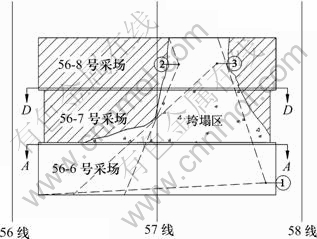
图1 采场垮塌区平面位置
Fig.1 Location of collapse area
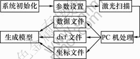
图2 CMS探测及后处理工作流程
Fig.2 Workflows of CMS and post-processing
1.3 采场垮塌区现场探测
由于CMS探测激光沿直线传播,在探测过程中,如遇遮挡或阻挡(如顶板锚索、矿柱、空区存留矿石等),部分区域将无法准确探测,出现探测盲区。对于复杂边界采场垮塌区56-7号,可以探测的位置有5个,通过现场观察,决定精选3个位置进行多点探测,测点位置如图1所示。从图1可以看出:每个测点探测时均有部分局域被遮挡,其中,测点1探测位置最佳,探测范围最大,遮挡局域最少,对于测点1无法探测到的盲区,通过测点2和测点3能较好地补充。因此,为尽可能准确探测垮塌区的实际三维边界,选择图1所示3个位置进行多次探测,将3次探测结果进行复合,从而获得准确的垮塌后空区三维模型。
2 采场垮塌区三维模型生成
2.1 空区三维模型构建方法
CMS探测垮塌区所获得的原始数据需采用CMS预处理软件CMSPosProcess进行处理,以形成dxf格式的原始数据文件,该文件可被第三方软件Surpac和Gocad等接受,用以生成垮塌后空区三维实体模型。
垮塌区原始探测数据处理后,运用Surpac生成空区三维实体模型的具体步骤如下。
第1步:利用Surpac数据导入接口将“.dxf”格式文件转换成实体模型的“.DTM”格式文件。
第2步:验证实体模型。
第3步:若实体模型验证有错误,则进入第4步,否则进行第5步。
第4步:重新进行原始探测数据的转换及处理,返回至第1步。
第5步:利用Surpac的实体模型编辑工具对垮塌区模型进行必要的编辑(通常采用实体模型布尔运算的方法对垮塌区旁的巷道部分进行切割处理)。
第6步:再次验证修改后的实体模型,若错误,则返回至第5步,再次编辑模型;反之,完成空区三维模型构建[10-16]。
2.2 采场垮塌区三维模型构建
采用空区三维模型构建方法分别建立3次探测的采场垮塌后空区三维模型,并将模型进行修正(主要对巷道部分进行剪切),最后复合3次探测获得的模型,形成完整的垮塌后空区三维模型,如图3所示。

图3 不同探测位置获得的采场垮塌后空区模型复合
Fig.3 Composite model of cavity after stope collapse in different monitoring positions
根据垮塌后空区模型和采场设计边界,通过模型布尔运算建立垮塌区三维模型,如图4所示。

图4 采场垮塌区三维模型
Fig.4 Collapse area 3D model
2.3 采场垮塌区剖面生成
通过采场垮塌后生成的空区和垮塌区三维模型,可以全方位掌握垮塌区综合信息,包括垮塌区三维形态、位置、体积、顶板暴露面积及存留矿石量等。利用Surpac可以对垮塌后空区模型沿任意方向进行剖
切,形成空区剖面,所生成的空区剖面可为矿山对垮塌区的处理提供必要的依据。为此,分别沿采场56-6号(A-A剖面)、56-7号(采场中心线)和56-8号(D-D剖面)等重要位置(如图1所示)对空区进行剖切,生成的剖面与采场设计边界进行对比,分别如图5~7所示。
通过沿垮塌区3个典型位置剖切,将剖切的空区模型与原采场设计边界进行对比,不难看出:
(1) 通过多点探测,可准确获得垮塌区形态大小和位置边界,探测模型与实际设计模型基本吻合。
(2) 56-7号垮塌区以下部分,从上到下依次为矿石和未采矿体,但两者分界面尚不能准确得出,待56-6号和56-8号采场存留矿石出完,再次对该区域进行探测,方能准确掌握分界面位置。

图5 56-6号空区模型与设计边界对比(A-A剖面)
Fig.5 Boundary comparison between design and cavity model of stope No.56-6

图6 56-7号空区模型与设计边界对比(采场中心位置)
Fig.6 Boundary comparison between design and cavity model of stope No.56-7

图7 56-8号空区模型与设计边界对比(D-D剖面)
Fig.7 Boundary comparison between design and cavity model of stope No.56-8
(3) 由于空区被遮挡,56-8号探测边界与设计边界不完全相符,采场靠56线下部有部分空区未能探测完全。
(4) 56-6号和56-8号采场垮塌区以下存留了大量矿石,应及时予以回收。
3 垮塌后空区体积及顶板暴露面积计算
3.1 垮塌后空区体积计算
根据垮塌区三维模型,结合各个采场设计边界,通过模型布尔运算分别创建3个采场空区三维实体模型,并计算其体积,结果见表1所示。
3.2 空区顶板暴露面积计算
空区顶板暴露面积是评价空区安全程度的1项重要指标。冬瓜山铜矿正常开采条件下,单个采场空区顶板暴露面积设计为1 440 m2,但由于56-7号采场垮塌,空区连通,致使顶板暴露面积大大增加,直接影响后续采场回采。为此,利用垮塌后空区三维模型计算空区顶板暴露面积具有非常重要的意义。
表1 垮塌后空区体积计算结果
Table 1 Calculation results of cavity volume m3

在-760 m水平沿垮塌后空区三维模型切水平剖面,生成的水平剖面经计算面积为2 661 m2,即为采场垮塌后空区顶板暴露面积。图8所示为-760 m垮塌后空区剖面与采场设计边界复合情况。从图8可以看出:56-6号采场部分区域存在超挖和欠挖现象。

图8 -760 m垮塌后空区剖面与采场设计边界复合
Fig.8 Composite of cavity section and stope design in -760 m
4 采场垮塌范围确定及存留矿量计算
4.1 采场垮塌范围确定
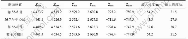
选取垮塌区三维模型靠56-6号采场、56-7号采场中心线及靠56-8号采场3个典型位置对垮塌区进行剖切,生成剖面。根据剖面位置,最终确定垮塌区范围(见表2)。
根据采场垮塌区模型,计算56-7号采场垮塌体积为22 032 m3,采场垮塌量为81 518 t。
4.2 采场底部结构模型构建
采用Surpac,结合冬瓜山采场底部结构设计剖面图,建立采场底部结构模型步骤如下。
第1步:提取采场爆破设计剖面底部结构部分线,并保存为“.dxf”格式文件。
第2步:将“.dxf”格式文件转换成Surpac “.str”格式线文件。
表2 采场垮塌区范围
Table 2 Range of collapse area
第3步:剖面线空间三维坐标转换。
第4步:利用实体模型生成功能建立采场底部结构三维实体模型[14],如图9所示。其中,采场进路间距为13.5 m,进路与出矿巷道交角为50?,堑沟坡面倾角为45?。
4.3 采场矿堆模型构建
结合采场实测空区模型、底部结构模型和采场爆破设计剖面图建立56-6号和56-8号采场矿堆模型,将所建立的采场矿堆模型与底部结构、采场垮塌区和56-7号采场设计模型进行复合,结果如图10所示。

图9 采场底部结构三维模型
Fig.9 3D model of stope bottom structure

图10 垮塌区、矿堆、底部结构与采场设计模型复合
Fig.10 Composite model of collapse area, ore heap, bottom structure and stope design model
4.4 存留矿石量计算
利用采场底部结构与矿堆三维模型计算其体积,进而计算存留矿石量,其结果见表3。
表3 采场存留矿石量计算结果
Table 3 Ore remains calculation result of stopes

5 结论
(1) 采场56-7号与旁边采场已经连通,并与旁边采场形成1个复杂大型空区,空区体积为102 982 m3,空区顶板暴露面积为2 661 m2。
(2) 采场垮塌区长、宽、高最大值分别为54.2,18.0和31.5 m;垮塌区体积为22 032 m3,垮塌量为81 518 t。
(3) 目前56-6号和56-8号采场内存留了大量矿石,矿石量分别为70 126 t和78 992 t,总计149 118 t。
(4) 利用探测成果生成的采场垮塌区回采设计平剖面图,可为矿山在空区周边进行相关开采设计等工作提供必要的依据。
(5) 针对采场周围迫切需要解决的剩余矿石回收问题,建议暂时停止采场垮塌区周围采场的爆破工作,先回收采场内存留矿石,待存留矿石出完,有条件可以再次对垮塌区进行探测,获得最新垮塌区及周围采场信息,再全盘考虑剩余矿石回收方案;由于顶板暴露面积已经非常大,因此,可以考虑在回收矿石前对整个空区通过上部充填巷道进行胶结充填,空区充填后,再根据探测成果(空区平剖面图)进行周围矿石的回采设计工作。
参考文献:
[1] 何满潮, 李学元, 刘斌, 等. 深部开采岩体力学研究[J]. 岩石力学与工程学报, 2005, 24(16): 2803-2813.
HE Man-chao, LI Xue-yuan, LIU Bin, et al. Study on 3D visual modeling technique of unstratified rock masses[J]. Chinese Journal of Rock Mechanics and Engineering, 2005, 24(16): 2803-2813.
[2] 杨承祥. 深井金属矿床高效开采及地压监控技术研究[D]. 中南大学资源与安全工程学院, 2007: 1-15.
YANG Cheng-xiang. Investigation on the technologies of high efficiency mining and ground pressure monitoring and control for deep metal deposit mining[D]. Central South University. School of Resources and Safety Engineering, 2007: 1-15.
[3] 刘晓明, 罗周全, 孙利娟, 等. 空区激光探测系统在我国的研究与应用[J]. 西安科技大学学报, 2008, 28(2): 611-614.
LIU Xiao-ming, LUO Zhou-quan, SUN Li-juan, et al. Research and application of cavity monitoring system in China[J]. Journal of Xi'an University of Science and Technology, 2008, 28(2): 611-614.
[4] 罗周全, 鹿浩, 刘晓明, 等. 基于空区探测的采场超欠挖量计算及顶板安全分析[J]. 金属矿山, 2007(12): 36-38.
LUO Zhou-quan, LU Hao, LIU Xiao-ming, et al. The volume calculation of stope over-excavation and under-excavation and upper openings safety analysis base on CMS survey[J]. Metal Mine, 2007(12): 36-38.
[5] Optech System Corporation. Cavity Monitoring System wireless user manual[M]. Toronto: Optech System Corporation, 2004: 10-15.
[6] Jarosz A, Shepherd L. Application of Cavity Monitoring System for control of dilution and ore loss in open stopes[C]//11th International Congress of ISM, Cracow, Poland, 2000: 155-164.
[7] Huber D, Vandapel N. Automatic 3D underground mine mapping[J]. International Journal of Robotics Research, 2005, 25(1): 7-17.
[8] 刘晓明, 罗周全, 张保, 等. CMS空区探测的环境影响及误差分析与纠正[J]. 矿冶工程, 2008, 28(4): 1-5.
LIU Xiao-ming, LUO Zhou-quan, ZHANG Bao, et al. Error analysis and amend of model under environmental impact for Cavity Monitoring System[J]. Mining and Metallurgical Engineering, 2008, 28(4): 1-5.
[9] LUO Zhou-quan, LIU Xiao-ming, SU Jia-hong, et al. Deposit 3D modeling and application[J]. Journal of Central South University of Technology, 2007, 14(2): 225-229.
[10] 刘晓明, 罗周全, 孙利娟, 等. 三维GIS空间数据集成和可视化技术研究[J]. 科技导报, 2008, 26(10): 65-68.
LIU Xiao-ming, LUO Zhou-quan, SUN Li-juan, et al. Integration of 3D GIS spatial data and its visualization[J]. Science and Technology Review, 2008, 26(10): 65-68.
[11] Lemon A M, Jones N L. Building solid models from boreholes and user-defined cross-sections[J]. Computers & Geosciences, 2003, 29(3): 547-555.
[12] John G H, Hani S M. Numerical modeling of ore dilution in blasthole stoping[J]. International Journal of Rock Mechanics and Mining Sciences, 2007, 44(5): 692-703.
[13] LIU Yu-zhou, LI Xiao-hong. Safety analysis of stability of surface gas drainage boreholes above goaf areas[J]. Journal of China Coal Society, 2007, 13(2): 149-153.
[14] GONG Jian-ya, CHENG Peng-gen, WANG Dong-yang. Three dimensional modeling and application in geological exploration engineering[J]. Computers & Geosciences, 2004, 30(4): 391-404.
[15] LUO Zhou-quan, LIU Xiao-ming, ZHANG Bao, et al. Cavity 3D modeling and correlative techniques based on cavity monitoring[J]. Journal of Central South University of Technology, 2008, 15(5): 639-644.
[16] 周智勇, 陈建宏, 杨立兵. 大型矿山地矿工程三维可视化模型的构建[J]. 中南大学学报: 自然科学版, 2008, 39(3): 423-428.
ZHOU Zhi-yong, CHEN Jian-hong, YANG Li-bing. 3D visualization modeling on geological and mining engineering in a large-sized mine[J]. Journal of Central South University: Science and Technology, 2008, 39(3): 423-428.
(编辑 赵俊)
收稿日期:2009-10-07;修回日期:2009-12-10
基金项目:“十一五”国家科技支撑计划项目(2007BAK22B04-12, 2006BAB02B04-1-3-2, 2006BAB02B05-1-2-1);中南大学研究生学位论文创新项目(1960-71131100008)
通信作者:刘晓明(1982-),男,江西新余人,博士,讲师,从事矿床深井开采与安全预警数字化技术的研究;电话:13755031441;E-mail: liuxiaoming33@163.com

